AppBrain
|
Apps
Apps
Apps being viewed right now
Trending apps today
Most popular apps
All-time most downloaded apps
Top rated apps
Statistics
Docs
Developers
Sign up
Log in
Android Apps
>
Maps & Navigation
>
Paid
Category
Maps & Navigation
Sort by
Trending
Recent downloads
All-time downloads
Top rated
Popular in
Filter by
Off
Free
Paid
New
Updated
Price Reduced
No ads
Page 10 of the
popular Paid Maps & Navigation Apps for Android in Canada
Fique Seguro S José dos Campos
Fifth Level
O aplicativo "Fique Seguro São José dos Campos" mostra a frequência de ocorrências policiais, por logradouro, no município de São José dos Cam…
$1.99
0.0
5+ downloads
|
Maps & Navigation
0.0
$1.99
Fifth Level
5+ downloads
TRANSPORTATION
Fique Seguro S José dos Campos
O aplicativo "Fique Seguro São José dos Campos" mostra a frequência de ocorrências …
Yosemite National Park GPS Map – Click to show
Yosemite National Park GPS Map
FLYTOMAP INC
Flytomap is a valid and interesting alternative, Featured on the Deck Featured on Geomedia Worldwide Marine and Outdoor Maps available when connected, thanks to viewer.flytomap.com Worldwide Satellit…
$3.99
0.0
10+ downloads
|
Maps & Navigation
0.0
$3.99
FLYTOMAP INC
10+ downloads
TRANSPORTATION
Yosemite National Park GPS Map
Flytomap is a valid and interesting alternative, Featured on the Deck Featured on Geomedia Worldwide Marine and Outdoor…
Wister Lake OK Offline Charts – Click to show
Wister Lake OK Offline Charts
MAPITECH LTD
MapiTech launches on the market the best official up-to-date NOAA RNC (raster) combined with S57 nautical charts (digital): marinas, wrecks, fishing spots, boat ramps, POI. This app displays seamles…
$4.99
0.0
1+ downloads
|
Maps & Navigation
0.0
$4.99
MAPITECH LTD
1+ downloads
TRANSPORTATION
Wister Lake OK Offline Charts
MapiTech launches on the market the best official up-to-date NOAA RNC (raster) combined with S57 nautical charts (digit…
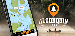
Algonquin Park Adventure Map
Backroad Mapbooks
The Algonquin Park Adventure Map app is an offline navigation app showing all the paddling routes, campsites, trails, fishing locations, roadside attractions, wildlife viewing areas and more. The app…
$8.49
0.0
100+ downloads
|
Maps & Navigation
0.0
$8.49
Backroad Mapbooks
100+ downloads
TRANSPORTATION
Algonquin Park Adventure Map
The Algonquin Park Adventure Map app is an offline navigation app showing all the paddling routes, campsites, trails, f…
Zurich Greifen Pfäffikon Chart – Click to show
Zurich Greifen Pfäffikon Chart
FLYTOMAP INC
Flytomap is a valid and interesting alternative, Featured on the Deck Featured on Geomedia Worldwide Marine and Outdoor Maps available when connected, thanks to viewer.flytomap.com Worldwide Satelli…
$3.99
0.0
10+ downloads
|
Maps & Navigation
0.0
$3.99
FLYTOMAP INC
10+ downloads
TRANSPORTATION
Zurich Greifen Pfäffikon Chart
Flytomap is a valid and interesting alternative, Featured on the Deck Featured on Geomedia Worldwide Marine and Outdoo…
Lake Texoma GPS Offline Charts – Click to show
Lake Texoma GPS Offline Charts
MAPITECH LTD
MapiTech launches on the market the best official up-to-date NOAA RNC (raster) combined with S57 nautical charts (digital): marinas, wrecks, fishing spots, boat ramps, POI. This app displays seamles…
$4.99
0.0
10+ downloads
|
Maps & Navigation
0.0
$4.99
MAPITECH LTD
10+ downloads
TRANSPORTATION
Lake Texoma GPS Offline Charts
MapiTech launches on the market the best official up-to-date NOAA RNC (raster) combined with S57 nautical charts (digit…
Aviation FlightTimes PRO Key
Marc Ole Bulling
Money-Back-Guarantee! If you don't like the app, a full refund will be issued Pro Features include: - Worldwide database of more than 25000 airports, including ultra light and glider airfields - Di…
$5.49
0.0
10+ downloads
|
Maps & Navigation
0.0
$5.49
Marc Ole Bulling
10+ downloads
TRANSPORTATION
Aviation FlightTimes PRO Key
Money-Back-Guarantee! If you don't like the app, a full refund will be issued Pro Features include: - Worldwide datab…
Lake Francis Case S Dakota Map – Click to show
Lake Francis Case S Dakota Map
MAPITECH LTD
MapiTech launches on the market the best official up-to-date NOAA RNC (raster) combined with S57 nautical charts (digital): marinas, wrecks, fishing spots, boat ramps, POI. This app displays seamles…
$4.99
0.0
1+ downloads
|
Maps & Navigation
0.0
$4.99
MAPITECH LTD
1+ downloads
TRANSPORTATION
Lake Francis Case S Dakota Map
MapiTech launches on the market the best official up-to-date NOAA RNC (raster) combined with S57 nautical charts (digit…
Satnav Cycle Routes- Cambridge – Click to show
Satnav Cycle Routes- Cambridge
Ian Lochhead
Four Satnav Cycle Routes around Cambridge using cycle paths and roads. 1. Around Cambridge. 12 miles 2. Cambridge - Reach. 31 miles 3. Cambridge - St Ives. 32 miles 4. Cambridge - Waterbeach. 21 mile…
$0.99
0.0
0+ downloads
|
Maps & Navigation
0.0
$0.99
Ian Lochhead
0+ downloads
TRANSPORTATION
Satnav Cycle Routes- Cambridge
Four Satnav Cycle Routes around Cambridge using cycle paths and roads. 1. Around Cambridge. 12 miles 2. Cambridge - Rea…
Calabria Offline GPS Charts – Click to show
Calabria Offline GPS Charts
MAPITECH LTD
MapiTech launches on the market the best official up-to-date RNC (raster) combined with S57 nautical charts (digital): marinas, wrecks, fishing spots, boat ramps, POI. This app displays seamlessly …
$4.99
0.0
0+ downloads
|
Maps & Navigation
0.0
$4.99
MAPITECH LTD
0+ downloads
TRANSPORTATION
Calabria Offline GPS Charts
MapiTech launches on the market the best official up-to-date RNC (raster) combined with S57 nautical charts (digital):…
Mälaren sjö Sverige GPS Karta – Click to show
Mälaren sjö Sverige GPS Karta
MAPITECH LTD
MapiTech launches on the market the best official up-to-date RNC (raster) combined with S57 nautical charts (digital): marinas, wrecks, fishing spots, boat ramps, POI. This app displays seamlessly …
$4.99
0.0
10+ downloads
|
Maps & Navigation
0.0
$4.99
MAPITECH LTD
10+ downloads
TRANSPORTATION
Mälaren sjö Sverige GPS Karta
MapiTech launches on the market the best official up-to-date RNC (raster) combined with S57 nautical charts (digital):…
Kaizala GPS
JKL Team
Aplikasi GPS palsu yang menetapkan lokasi GPS sehingga aplikasi lain di ponsel Anda percaya Anda ada di sana. Dengan aplikasi aplikasi ini Anda akan mendapatkan koordinat yang alami dan wajar seperti…
$0.99
0.0
500+ downloads
|
Maps & Navigation
0.0
$0.99
JKL Team
500+ downloads
TRANSPORTATION
Kaizala GPS
Aplikasi GPS palsu yang menetapkan lokasi GPS sehingga aplikasi lain di ponsel Anda percaya Anda ada di sana. Dengan ap…
Pennsylvania Mushroom Forager – Click to show
Pennsylvania Mushroom Forager
GeoPOI LLC
The forests and woodlands of Pennsylvania are ecosystems rich with edible wild mushrooms if you know where to look. Trouble is, seasoned wild edible collectors seldom share their 'honey holes', and s…
$1.49
0.0
1+ downloads
|
Maps & Navigation
0.0
$1.49
GeoPOI LLC
1+ downloads
TRANSPORTATION
Pennsylvania Mushroom Forager
The forests and woodlands of Pennsylvania are ecosystems rich with edible wild mushrooms if you know where to look. Tro…
Two Inlets Lake GPS Navigator – Click to show
Two Inlets Lake GPS Navigator
FLYTOMAP INC
Flytomap is a valid and interesting alternative, Featured on the Deck Featured on Geomedia Worldwide Marine and Outdoor Maps available when connected, thanks to viewer.flytomap.com Worldwide Satellit…
$3.99
0.0
0+ downloads
|
Maps & Navigation
0.0
$3.99
FLYTOMAP INC
0+ downloads
TRANSPORTATION
Two Inlets Lake GPS Navigator
Flytomap is a valid and interesting alternative, Featured on the Deck Featured on Geomedia Worldwide Marine and Outdoor…
Malta GPS Map Navigator – Click to show
Malta GPS Map Navigator
FLYTOMAP INC
Flytomap is a valid and interesting alternative, Featured on the Deck Featured on Geomedia Worldwide Marine and Outdoor Maps available when connected, thanks to viewer.flytomap.com Worldwide Satelli…
$3.99
0.0
5+ downloads
|
Maps & Navigation
0.0
$3.99
FLYTOMAP INC
5+ downloads
TRANSPORTATION
Malta GPS Map Navigator
Flytomap is a valid and interesting alternative, Featured on the Deck Featured on Geomedia Worldwide Marine and Outdoo…
Germany GPS Map Navigator – Click to show
Germany GPS Map Navigator
FLYTOMAP INC
Flytomap is a valid and interesting alternative, Featured on the Deck Featured on Geomedia Worldwide Marine and Outdoor Maps available when connected, thanks to viewer.flytomap.com Worldwide Satellit…
$14.99
0.0
10+ downloads
|
Maps & Navigation
0.0
$14.99
FLYTOMAP INC
10+ downloads
TRANSPORTATION
Germany GPS Map Navigator
Flytomap is a valid and interesting alternative, Featured on the Deck Featured on Geomedia Worldwide Marine and Outdoor…
Lake Wapello IOWA GPS Charts – Click to show
Lake Wapello IOWA GPS Charts
FLYTOMAP INC
Flytomap is a valid and interesting alternative, Worldwide Marine and Outdoor Maps available when connected, thanks to viewer.flytomap.com Worldwide Satellite images overlay on charts Worldwide Ter…
$1.99
0.0
0+ downloads
|
Maps & Navigation
0.0
$1.99
FLYTOMAP INC
0+ downloads
TRANSPORTATION
Lake Wapello IOWA GPS Charts
Flytomap is a valid and interesting alternative, Worldwide Marine and Outdoor Maps available when connected, thanks to…
Başarsoft Nextgen
Basarsoft
Join millions of travelers around the world and take the journeys that matter. Using half the storage space of many other navigation apps, Basarsoft NextGen is an offline app that guides you on adven…
$7.13
0.0
1,000+ downloads
|
Maps & Navigation
0.0
$7.13
Basarsoft
1,000+ downloads
TRANSPORTATION
Başarsoft Nextgen
Join millions of travelers around the world and take the journeys that matter. Using half the storage space of many oth…
Compass Navigation {HarmonyOS} – Click to show
Compass Navigation {HarmonyOS}
Mobimax Apps
Compass Navigation supports phones and Harmony OS powered watches. ONLY this version can connect to Harmony OS powered watches. IMPORTANT: connection watch-phone apps is possible only on a view with …
$2.99
0.0
100+ downloads
|
Maps & Navigation
0.0
$2.99
Mobimax Apps
100+ downloads
TRANSPORTATION
Compass Navigation {HarmonyOS}
Compass Navigation supports phones and Harmony OS powered watches. ONLY this version can connect to Harmony OS powered …
Guntersville Lake Offline Maps – Click to show
Guntersville Lake Offline Maps
MAPITECH LTD
MapiTech launches on the market the best official up-to-date NOAA RNC (raster) combined with S57 nautical charts (digital): marinas, wrecks, fishing spots, boat ramps, POI. This app displays seamles…
$4.99
0.0
10+ downloads
|
Maps & Navigation
0.0
$4.99
MAPITECH LTD
10+ downloads
TRANSPORTATION
Guntersville Lake Offline Maps
MapiTech launches on the market the best official up-to-date NOAA RNC (raster) combined with S57 nautical charts (digit…
United States
United Kingdom
Germany
Norway
Sweden
Australia
Netherlands
Italy
Denmark
Hong Kong
Brazil
France
Canada
Spain
Portugal
South Korea
Japan
Poland
Hungary
India
Finland
Thailand
Russia
General
Overall
Applications
Games
Join AppBrain
Join AppBrain to get app recommendations
Apps
Art & Design
Auto & Vehicles
Beauty
Books & Reference
Business
Comics
Communication
Dating
Education
Entertainment
Events
Finance
Food & Drink
Health & Fitness
House & Home
Libraries & Demo
Lifestyle
Maps & Navigation
Medical
Music & Audio
News & Magazines
Parenting
Personalization
Photography
Productivity
Shopping
Social
Sports
Tools
Travel & Local
Video Players & Editors
Weather
Games
Action
Adventure
Arcade
Board
Card
Casino
Casual
Educational
Music
Puzzle
Racing
Role Playing
Simulation
Sports Games
Strategy
Trivia
Word