AppBrain
|
Apps
Apps
Apps being viewed right now
Trending apps today
Most popular apps
All-time most downloaded apps
Top rated apps
Statistics
Docs
Developers
Sign up
Log in
Android Apps
>
Maps & Navigation
>
Paid
Category
Maps & Navigation
Sort by
Trending
Recent downloads
All-time downloads
Top rated
Popular in
Filter by
Off
Free
Paid
New
Updated
Price Reduced
No ads
Page 3 of the
popular Paid Maps & Navigation Apps for Android in Finland
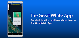
The Great White App
Sustainable Oceans Society
READ BEFORE PURCHASING: * This app will always be FREE on our website, sustainableoceansociety.co.nz * By purchasing this app you are supporting The Great White Project - a study of Great White Sha…
$2.99
0.0
1,000+ downloads
|
Maps & Navigation
0.0
$2.99
Sustainable Oceans Society
1,000+ downloads
TRANSPORTATION
The Great White App
READ BEFORE PURCHASING: * This app will always be FREE on our website, sustainableoceansociety.co.nz * By purchasing …
Galveston to Rio Grande Charts – Click to show
Galveston to Rio Grande Charts
MAPITECH LTD
MapiTech launches on the market the best official up-to-date NOAA RNC (raster) combined with S57 nautical charts (digital): marinas, wrecks, fishing spots, boat ramps, POI. This app displays seamles…
$4.99
0.0
0+ downloads
|
Maps & Navigation
0.0
$4.99
MAPITECH LTD
0+ downloads
TRANSPORTATION
Galveston to Rio Grande Charts
MapiTech launches on the market the best official up-to-date NOAA RNC (raster) combined with S57 nautical charts (digit…
Cozumel Island GPS Navigator – Click to show
Cozumel Island GPS Navigator
FLYTOMAP INC
Flytomap is a valid and interesting alternative, Featured on the Deck Featured on Geomedia Worldwide Marine and Outdoor Maps available when connected, thanks to viewer.flytomap.com Worldwide Satellit…
$3.99
0.0
1+ downloads
|
Maps & Navigation
0.0
$3.99
FLYTOMAP INC
1+ downloads
TRANSPORTATION
Cozumel Island GPS Navigator
Flytomap is a valid and interesting alternative, Featured on the Deck Featured on Geomedia Worldwide Marine and Outdoor…
Lake Yellowstone Wyoming Chart – Click to show
Lake Yellowstone Wyoming Chart
FLYTOMAP INC
Flytomap is a valid and interesting alternative, Featured on the Deck Featured on Geomedia Worldwide Marine and Outdoor Maps available when connected, thanks to viewer.flytomap.com Worldwide Satelli…
$3.99
0.0
0+ downloads
|
Maps & Navigation
0.0
$3.99
FLYTOMAP INC
0+ downloads
TRANSPORTATION
Lake Yellowstone Wyoming Chart
Flytomap is a valid and interesting alternative, Featured on the Deck Featured on Geomedia Worldwide Marine and Outdoo…
Lake Tarpon Florida GPS Charts – Click to show
Lake Tarpon Florida GPS Charts
FLYTOMAP INC
Flytomap is a valid and interesting alternative Featured on the Deck Featured on Geomedia Worldwide Marine and Outdoor Maps available when connected, thanks to viewer.flytomap.com Worldwide Satellite…
$2.99
0.0
0+ downloads
|
Maps & Navigation
0.0
$2.99
FLYTOMAP INC
0+ downloads
TRANSPORTATION
Lake Tarpon Florida GPS Charts
Flytomap is a valid and interesting alternative Featured on the Deck Featured on Geomedia Worldwide Marine and Outdoor …
Speed Camera AI: Radar Alerts
Slash Idea s.r.o.
Take the stress out of driving with Drive AI, the AI-powered app that makes radar alerts and navigation smarter and easier. Unlike regular speed camera apps, Drive AI learns your daily routes and fig…
$0.99
0.0
10+ downloads
|
Maps & Navigation
0.0
$0.99
Slash Idea s.r.o.
10+ downloads
TRANSPORTATION
Speed Camera AI: Radar Alerts
Take the stress out of driving with Drive AI, the AI-powered app that makes radar alerts and navigation smarter and eas…
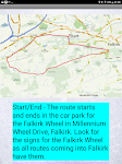
Satnav Cycle Routes – Falkirk – Click to show
Satnav Cycle Routes – Falkirk
Ian Lochhead
Around the Falkirk Wheel. 12.5 miles Falkirk - Avonbridge. 24 miles Falkirk - Fannyside Loch. 20 miles Falkirk Wheel & Helix Park. 12 miles Satnav Cycle Routes around Falkirk using cycle paths a…
$0.99
0.0
0+ downloads
|
Maps & Navigation
0.0
$0.99
Ian Lochhead
0+ downloads
TRANSPORTATION
Satnav Cycle Routes – Falkirk
Around the Falkirk Wheel. 12.5 miles Falkirk - Avonbridge. 24 miles Falkirk - Fannyside Loch. 20 miles Falkirk Wheel &a…
Pickwick Lake Al GPS Charts – Click to show
Pickwick Lake Al GPS Charts
FLYTOMAP INC
Flytomap is a valid and interesting alternative, Featured on the Deck Featured on Geomedia Worldwide Marine and Outdoor Maps available when connected, thanks to viewer.flytomap.com Worldwide Satelli…
$2.99
0.0
1+ downloads
|
Maps & Navigation
0.0
$2.99
FLYTOMAP INC
1+ downloads
TRANSPORTATION
Pickwick Lake Al GPS Charts
Flytomap is a valid and interesting alternative, Featured on the Deck Featured on Geomedia Worldwide Marine and Outdoo…
Madeira Island Offline Charts – Click to show
Madeira Island Offline Charts
MAPITECH LTD
MapiTech launches on the market the best official up-to-date RNC (raster) combined with S57 nautical charts (digital): marinas, wrecks, fishing spots, boat ramps, POI. This app displays seamlessly …
$4.99
0.0
10+ downloads
|
Maps & Navigation
0.0
$4.99
MAPITECH LTD
10+ downloads
TRANSPORTATION
Madeira Island Offline Charts
MapiTech launches on the market the best official up-to-date RNC (raster) combined with S57 nautical charts (digital):…
Oslo fjord Norway Offline Maps – Click to show
Oslo fjord Norway Offline Maps
MAPITECH LTD
MapiTech launches on the market the best official up-to-date RNC (raster) combined with S57 nautical charts (digital): marinas, wrecks, fishing spots, boat ramps, POI. This app displays seamlessly …
$4.99
0.0
5+ downloads
|
Maps & Navigation
0.0
$4.99
MAPITECH LTD
5+ downloads
TRANSPORTATION
Oslo fjord Norway Offline Maps
MapiTech launches on the market the best official up-to-date RNC (raster) combined with S57 nautical charts (digital):…
World Airports Pro
Waterline Software
World Airports Pro is a worldwide database of over 5000 of the world's principle airports and their runways permitting location and orientation through the medium of Google® Maps. Within this ap…
$1.49
0.0
100+ downloads
|
Maps & Navigation
0.0
$1.49
Waterline Software
100+ downloads
TRANSPORTATION
World Airports Pro
World Airports Pro is a worldwide database of over 5000 of the world's principle airports and their runways permitting …
Picardie GPS Map Navigator – Click to show
Picardie GPS Map Navigator
FLYTOMAP INC
Flytomap is a valid and interesting alternative, Featured on the Deck Featured on Geomedia Worldwide Marine and Outdoor Maps available when connected, thanks to viewer.flytomap.com Worldwide Satelli…
$3.99
0.0
0+ downloads
|
Maps & Navigation
0.0
$3.99
FLYTOMAP INC
0+ downloads
TRANSPORTATION
Picardie GPS Map Navigator
Flytomap is a valid and interesting alternative, Featured on the Deck Featured on Geomedia Worldwide Marine and Outdoo…
Fiji Islands GPS Map Navigator – Click to show
Fiji Islands GPS Map Navigator
FLYTOMAP INC
Flytomap is a valid and interesting alternative, Worldwide Marine and Outdoor Maps available when connected, thanks to viewer.flytomap.com Worldwide Satellite images overlay on charts Worldwide Terr…
$3.99
0.0
10+ downloads
|
Maps & Navigation
0.0
$3.99
FLYTOMAP INC
10+ downloads
TRANSPORTATION
Fiji Islands GPS Map Navigator
Flytomap is a valid and interesting alternative, Worldwide Marine and Outdoor Maps available when connected, thanks to …
Estepona Sines Offline GPS Map – Click to show
Estepona Sines Offline GPS Map
MAPITECH LTD
MapiTech launches on the market the best official up-to-date RNC (raster) combined with S57 nautical charts (digital): marinas, wrecks, fishing spots, boat ramps, POI. This app displays seamlessly …
$4.99
0.0
5+ downloads
|
Maps & Navigation
0.0
$4.99
MAPITECH LTD
5+ downloads
TRANSPORTATION
Estepona Sines Offline GPS Map
MapiTech launches on the market the best official up-to-date RNC (raster) combined with S57 nautical charts (digital):…
GeoLocate – GPS Tracker
Merkandian
GeoLocate is a powerful GPS tracker and location finder that helps you stay connected with friends and family. Using advanced geolocation technology, it lets you track phones, share live location, an…
$4.49
0.0
5+ downloads
|
Maps & Navigation
0.0
$4.49
Merkandian
5+ downloads
TRANSPORTATION
GeoLocate – GPS Tracker
GeoLocate is a powerful GPS tracker and location finder that helps you stay connected with friends and family. Using ad…
Satnav Cycle Routes - Dumfries – Click to show
Satnav Cycle Routes - Dumfries
Ian Lochhead
Dumfries - Annan. 43 miles Dumfries - Lochmabon. 40 miles Dumfries - New Abbey. 27 miles 3 Satnav Cycle Routes around Dumfries using cycle paths and roads on Google Maps. Every route has turn-by-tur…
$0.99
0.0
0+ downloads
|
Maps & Navigation
0.0
$0.99
Ian Lochhead
0+ downloads
TRANSPORTATION
Satnav Cycle Routes - Dumfries
Dumfries - Annan. 43 miles Dumfries - Lochmabon. 40 miles Dumfries - New Abbey. 27 miles 3 Satnav Cycle Routes around …
Greece West GPS Map Navigator – Click to show
Greece West GPS Map Navigator
FLYTOMAP INC
Flytomap is a valid and interesting alternative, Featured on the Deck Featured on Geomedia Worldwide Marine and Outdoor Maps available when connected, thanks to viewer.flytomap.com Worldwide Satellit…
$3.99
0.0
10+ downloads
|
Maps & Navigation
0.0
$3.99
FLYTOMAP INC
10+ downloads
TRANSPORTATION
Greece West GPS Map Navigator
Flytomap is a valid and interesting alternative, Featured on the Deck Featured on Geomedia Worldwide Marine and Outdoor…
Florida Everglades GPS Charts – Click to show
Florida Everglades GPS Charts
FLYTOMAP INC
Flytomap is a valid and interesting alternative, Featured on the Deck Featured on Geomedia Worldwide Marine and Outdoor Maps available when connected, thanks to viewer.flytomap.com Worldwide Satellit…
$3.99
0.0
0+ downloads
|
Maps & Navigation
0.0
$3.99
FLYTOMAP INC
0+ downloads
TRANSPORTATION
Florida Everglades GPS Charts
Flytomap is a valid and interesting alternative, Featured on the Deck Featured on Geomedia Worldwide Marine and Outdoor…
PORTA DEL CEL – Click to show
PORTA DEL CEL
Jorge Rodríguez-Flores Esparza
"Porta del Cel" is a medium distance circular route located in the Spanish and French Pyrenees. The trail runs through the "Parc Natural de l'Alt Pirineu" and the "Parc natur…
$1.99
0.0
0+ downloads
|
Maps & Navigation
0.0
$1.99
Jorge Rodríguez-Flores Esparza
0+ downloads
TRANSPORTATION
PORTA DEL CEL
"Porta del Cel" is a medium distance circular route located in the Spanish and French Pyrenees. The trail run…
Mojo TSD Navigator
RallyOn
Mojo TSD Navigator allows a time-speed-distance rally navigator (co-driver) to report to the driver whether to speed up or slow down in order to arrive at the next rally checkpoint exactly on time an…
$19.99
0.0
10+ downloads
|
Maps & Navigation
0.0
$19.99
RallyOn
10+ downloads
TRANSPORTATION
Mojo TSD Navigator
Mojo TSD Navigator allows a time-speed-distance rally navigator (co-driver) to report to the driver whether to speed up…
United States
United Kingdom
Germany
Norway
Sweden
Australia
Netherlands
Italy
Denmark
Hong Kong
Brazil
France
Canada
Spain
Portugal
South Korea
Japan
Poland
Hungary
India
Finland
Thailand
Russia
General
Overall
Applications
Games
Join AppBrain
Join AppBrain to get app recommendations
Apps
Art & Design
Auto & Vehicles
Beauty
Books & Reference
Business
Comics
Communication
Dating
Education
Entertainment
Events
Finance
Food & Drink
Health & Fitness
House & Home
Libraries & Demo
Lifestyle
Maps & Navigation
Medical
Music & Audio
News & Magazines
Parenting
Personalization
Photography
Productivity
Shopping
Social
Sports
Tools
Travel & Local
Video Players & Editors
Weather
Games
Action
Adventure
Arcade
Board
Card
Casino
Casual
Educational
Music
Puzzle
Racing
Role Playing
Simulation
Sports Games
Strategy
Trivia
Word