Android Apps
>
Maps & Navigation
> Paid
Category
Maps & Navigation
Sort by
Trending
Recent downloads
All-time downloads
Top rated
Popular in
Filter by
Off
Free
Paid
New
Updated
Price Reduced
No ads
Page 7 of the popular Paid Maps & Navigation Apps for Android in France
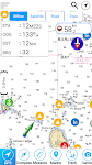
Barcelona Benidorm Offline Map
MAPITECH LTD

MapiTech launches on the market the best official up-to-date RNC (raster) combined with S57 nautical charts (digital): marinas, wrecks, fishing spots, boat ramps, POI.
This app displays seamlessly …


$4.99
0.0
0+ downloads
|
Maps & Navigation
0.0
$4.99
MAPITECH LTD
0+ downloads
TRANSPORTATION
0+ downloads
TRANSPORTATION
Barcelona Benidorm Offline Map
MapiTech launches on the market the best official up-to-date RNC (raster) combined with S57 nautical charts (digital):…
Lake Maggiore Offline Charts
MAPITECH LTD

MapiTech launches on the market the best official up-to-date RNC (raster) combined with S57 nautical charts (digital): marinas, wrecks, fishing spots, boat ramps, POI.
This app displays seamlessly …


$4.99
0.0
50+ downloads
|
Maps & Navigation
0.0
$4.99
MAPITECH LTD
50+ downloads
TRANSPORTATION
50+ downloads
TRANSPORTATION
Lake Maggiore Offline Charts
MapiTech launches on the market the best official up-to-date RNC (raster) combined with S57 nautical charts (digital):…
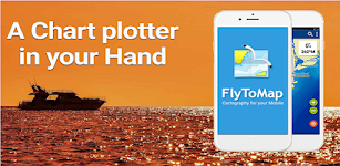
Greenfield Lake - IOWA GPS Map
FLYTOMAP INC

Flytomap is a valid and interesting alternative,
Featured on the Deck
Featured on Geomedia
Worldwide Marine and Outdoor Maps available when connected, thanks to viewer.flytomap.com
Worldwide Satellit…


$2.99
0.0
1+ downloads
|
Maps & Navigation
0.0
$2.99
FLYTOMAP INC
1+ downloads
TRANSPORTATION
1+ downloads
TRANSPORTATION
Greenfield Lake - IOWA GPS Map
Flytomap is a valid and interesting alternative,
Featured on the Deck
Featured on Geomedia
Worldwide Marine and Outdoor…
Spain Atlantic Map Navigator
FLYTOMAP INC

Flytomap is a valid and interesting alternative,
Featured on the Deck
Featured on Geomedia
Worldwide Marine and Outdoor Maps available when connected, thanks to viewer.flytomap.com
Worldwide Satellit…


$4.99
0.0
10+ downloads
|
Maps & Navigation
0.0
$4.99
FLYTOMAP INC
10+ downloads
TRANSPORTATION
10+ downloads
TRANSPORTATION
Spain Atlantic Map Navigator
Flytomap is a valid and interesting alternative,
Featured on the Deck
Featured on Geomedia
Worldwide Marine and Outdoor…
Yorkshire Dales Outdoor Map Pr
jonathan shutt

An offline map of the Yorkshire Dales National Park in England, ideal for hiking, running, mountain biking / cycling. Being offline means unlike other map apps, you don't need a signal to access deta…


$1.99
0.0
100+ downloads
|
Maps & Navigation
0.0
$1.99
jonathan shutt
100+ downloads
TRANSPORTATION
100+ downloads
TRANSPORTATION
Yorkshire Dales Outdoor Map Pr
An offline map of the Yorkshire Dales National Park in England, ideal for hiking, running, mountain biking / cycling. B…
Wagitaler Sihl Klontaler Chart
FLYTOMAP INC

Flytomap is a valid and interesting alternative,
Featured on the Deck
Featured on Geomedia
Worldwide Marine and Outdoor Maps available when connected, thanks to viewer.flytomap.com
Worldwide Satelli…

$3.99
0.0
0+ downloads
|
Maps & Navigation
0.0
$3.99
FLYTOMAP INC
0+ downloads
TRANSPORTATION
0+ downloads
TRANSPORTATION
Wagitaler Sihl Klontaler Chart
Flytomap is a valid and interesting alternative,
Featured on the Deck
Featured on Geomedia
Worldwide Marine and Outdoo…
Georgia S to N Carolina Charts
FLYTOMAP INC

Flytomap is a valid and interesting alternative,
Featured on the Deck
Featured on Geomedia
Worldwide Marine and Outdoor Maps available when connected, thanks to viewer.flytomap.com
Worldwide Satellit…


$3.99
0.0
0+ downloads
|
Maps & Navigation
0.0
$3.99
FLYTOMAP INC
0+ downloads
TRANSPORTATION
0+ downloads
TRANSPORTATION
Georgia S to N Carolina Charts
Flytomap is a valid and interesting alternative,
Featured on the Deck
Featured on Geomedia
Worldwide Marine and Outdoor…
Manhattan Fallout Shelters Map
GeoPOI LLC

Navigate an interactive map of nearly 25,000 points representing the locations of surveyed nuclear fallout shelters across the entirety of Manhattan Island in New York City. This includes all of the …


$3.99
0.0
0+ downloads
|
Maps & Navigation
0.0
$3.99
GeoPOI LLC
0+ downloads
TRANSPORTATION
0+ downloads
TRANSPORTATION
Manhattan Fallout Shelters Map
Navigate an interactive map of nearly 25,000 points representing the locations of surveyed nuclear fallout shelters acr…
Starry Starry Day Professional
Mapsoft

Starry Starry Day Pro allows the daytime use of a total station to rapidly obtain highly accurate True and Grid North azimuths to astro objects without needing an internet connection.
Brief Usage In…


$0.49
0.0
10+ downloads
|
Maps & Navigation
0.0
$0.49
Mapsoft
10+ downloads
TRANSPORTATION
10+ downloads
TRANSPORTATION
Starry Starry Day Professional
Starry Starry Day Pro allows the daytime use of a total station to rapidly obtain highly accurate True and Grid North a…
Pocket Compass: Navigation
ASD Media

**POCKET COMPASS: SIMPLE, ACCURATE NAVIGATION**
Navigate with confidence using Pocket Compass, a sleek and accurate digital compass designed for outdoor enthusiasts, hikers, travellers, and anyone w…


$0.99
0.0
1+ downloads
|
Maps & Navigation
0.0
$0.99
ASD Media
1+ downloads
TRANSPORTATION
1+ downloads
TRANSPORTATION
Pocket Compass: Navigation
**POCKET COMPASS: SIMPLE, ACCURATE NAVIGATION**
Navigate with confidence using Pocket Compass, a sleek and accurate di…
OBD Info-san!
ganchi

note: The text translates the original Japanese with a Google translation.
[Operation check in the trial version! 】
Although this application is charged, there is a possibility that it will not oper…


$4.99
0.0
5,000+ downloads
|
Maps & Navigation
0.0
$4.99
ganchi
5,000+ downloads
TRANSPORTATION
5,000+ downloads
TRANSPORTATION
OBD Info-san!
note: The text translates the original Japanese with a Google translation.
[Operation check in the trial version! 】
Al…
Lake Seminole Offline Charts
MAPITECH LTD

MapiTech launches on the market the best official up-to-date NOAA RNC (raster) combined with S57 nautical charts (digital): marinas, wrecks, fishing spots, boat ramps, POI.
This app displays seamles…


$4.99
0.0
0+ downloads
|
Maps & Navigation
0.0
$4.99
MAPITECH LTD
0+ downloads
TRANSPORTATION
0+ downloads
TRANSPORTATION
Lake Seminole Offline Charts
MapiTech launches on the market the best official up-to-date NOAA RNC (raster) combined with S57 nautical charts (digit…
Mallorca Menorca Offline Chart
MAPITECH LTD

MapiTech launches on the market the best official up-to-date RNC (raster) combined with S57 nautical charts (digital): marinas, wrecks, fishing spots, boat ramps, POI.
This app displays seamlessly …


$4.99
0.0
1+ downloads
|
Maps & Navigation
0.0
$4.99
MAPITECH LTD
1+ downloads
TRANSPORTATION
1+ downloads
TRANSPORTATION
Mallorca Menorca Offline Chart
MapiTech launches on the market the best official up-to-date RNC (raster) combined with S57 nautical charts (digital):…
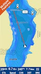
Lake Vanern GPS Fishing Charts
FLYTOMAP INC

Flytomap is a valid and interesting alternative,
Worldwide Marine and Outdoor Maps available when connected, thanks to viewer.flytomap.com
Worldwide Satellite images overlay on charts
Worldwide Ter…


$3.99
0.0
10+ downloads
|
Maps & Navigation
0.0
$3.99
FLYTOMAP INC
10+ downloads
TRANSPORTATION
10+ downloads
TRANSPORTATION
Lake Vanern GPS Fishing Charts
Flytomap is a valid and interesting alternative,
Worldwide Marine and Outdoor Maps available when connected, thanks to…
What Street?
Applorium Ltd

Welcome to What Street? – the ultimate street name identification app that tells you exactly where you are!
Have you ever found yourself lost in a new city, wandering aimlessly down unfamiliar…


$1.99
0.0
100+ downloads
|
Maps & Navigation
0.0
$1.99
Applorium Ltd
100+ downloads
TRANSPORTATION
100+ downloads
TRANSPORTATION
What Street?
Welcome to What Street? – the ultimate street name identification app that tells you exactly where you are!
Have…
Helsinki GPS Map Navigator
FLYTOMAP INC

Flytomap is a valid and interesting alternative,
Featured on the Deck
Featured on Geomedia
Worldwide Marine and Outdoor Maps available when connected, thanks to viewer.flytomap.com
Worldwide Satelli…


$3.99
0.0
5+ downloads
|
Maps & Navigation
0.0
$3.99
FLYTOMAP INC
5+ downloads
TRANSPORTATION
5+ downloads
TRANSPORTATION
Helsinki GPS Map Navigator
Flytomap is a valid and interesting alternative,
Featured on the Deck
Featured on Geomedia
Worldwide Marine and Outdoo…
Lake of the Ozarks GPS Charts
FLYTOMAP INC

Flytomap is a valid and interesting alternative,
Featured on the Deck
Featured on Geomedia
Worldwide Marine and Outdoor Maps available when connected, thanks to viewer.flytomap.com
Worldwide Satelli…


$3.99
0.0
100+ downloads
|
Maps & Navigation
0.0
$3.99
FLYTOMAP INC
100+ downloads
TRANSPORTATION
100+ downloads
TRANSPORTATION
Lake of the Ozarks GPS Charts
Flytomap is a valid and interesting alternative,
Featured on the Deck
Featured on Geomedia
Worldwide Marine and Outdoo…
Stora Le sjö Offline GPS Karta
MAPITECH LTD

MapiTech launches on the market the best official up-to-date RNC (raster) combined with S57 nautical charts (digital): marinas, wrecks, fishing spots, boat ramps, POI.
This app displays seamlessly …


$4.99
0.0
10+ downloads
|
Maps & Navigation
0.0
$4.99
MAPITECH LTD
10+ downloads
TRANSPORTATION
10+ downloads
TRANSPORTATION
Stora Le sjö Offline GPS Karta
MapiTech launches on the market the best official up-to-date RNC (raster) combined with S57 nautical charts (digital):…
Mille Lacs Gps Map Navigator
FLYTOMAP INC

Flytomap is a valid and interesting alternative,
Featured on the Deck
Featured on Geomedia
Worldwide Marine and Outdoor Maps available when connected, thanks to viewer.flytomap.com
Worldwide Satelli…


$3.99
0.0
50+ downloads
|
Maps & Navigation
0.0
$3.99
FLYTOMAP INC
50+ downloads
TRANSPORTATION
50+ downloads
TRANSPORTATION
Mille Lacs Gps Map Navigator
Flytomap is a valid and interesting alternative,
Featured on the Deck
Featured on Geomedia
Worldwide Marine and Outdoo…
Percy Priest Lake Offline Maps
MAPITECH LTD

MapiTech launches on the market the best official up-to-date NOAA RNC (raster) combined with S57 nautical charts (digital): marinas, wrecks, fishing spots, boat ramps, POI.
This app displays seamles…


$4.99
0.0
1+ downloads
|
Maps & Navigation
0.0
$4.99
MAPITECH LTD
1+ downloads
TRANSPORTATION
1+ downloads
TRANSPORTATION
Percy Priest Lake Offline Maps
MapiTech launches on the market the best official up-to-date NOAA RNC (raster) combined with S57 nautical charts (digit…
More apps
Android Statistics
© 2010-2024 - AppBrain