AppBrain
|
Apps
Apps
Apps being viewed right now
Trending apps today
Most popular apps
All-time most downloaded apps
Top rated apps
Statistics
Docs
Developers
Sign up
Log in
Android Apps
>
Maps & Navigation
>
Paid
Category
Maps & Navigation
Sort by
Trending
Recent downloads
All-time downloads
Top rated
Popular in
Filter by
Off
Free
Paid
New
Updated
Price Reduced
No ads
Page 9 of the
popular Paid Maps & Navigation Apps for Android in the Netherlands
Lake Hudson GPS Map Navigator – Click to show
Lake Hudson GPS Map Navigator
FLYTOMAP INC
Flytomap is a valid and interesting alternative, Featured on the Deck Featured on Geomedia Worldwide Marine and Outdoor Maps available when connected, thanks to viewer.flytomap.com Worldwide Satelli…
$3.99
0.0
0+ downloads
|
Maps & Navigation
0.0
$3.99
FLYTOMAP INC
0+ downloads
TRANSPORTATION
Lake Hudson GPS Map Navigator
Flytomap is a valid and interesting alternative, Featured on the Deck Featured on Geomedia Worldwide Marine and Outdoo…
TMBmap Tour du Mont Blanc TMB
ARiS websitewerk
This App shows the Tour du Mont Blanc route with all its variations. On the free website TMBmap.com you can organize your self-guided TMB route: Create your personal TMB route, plan accommodations …
$13.99
0.0
10+ downloads
|
Maps & Navigation
0.0
$13.99
ARiS websitewerk
10+ downloads
TRANSPORTATION
TMBmap Tour du Mont Blanc TMB
This App shows the Tour du Mont Blanc route with all its variations. On the free website TMBmap.com you can organize yo…
Virgin Islands Offline Charts – Click to show
Virgin Islands Offline Charts
MAPITECH LTD
MapiTech launches on the market the best official up-to-date RNC (raster) combined with S57 nautical charts (digital): marinas, wrecks, fishing spots, boat ramps, POI. This app displays seamlessly …
$5.99
0.0
5+ downloads
|
Maps & Navigation
0.0
$5.99
MAPITECH LTD
5+ downloads
TRANSPORTATION
Virgin Islands Offline Charts
MapiTech launches on the market the best official up-to-date RNC (raster) combined with S57 nautical charts (digital):…
Lake Como GPS Map Navigator – Click to show
Lake Como GPS Map Navigator
FLYTOMAP INC
Flytomap is a valid and interesting alternative, Featured on the Deck Featured on Geomedia Worldwide Marine and Outdoor Maps available when connected, thanks to viewer.flytomap.com Worldwide Satelli…
$3.99
0.0
10+ downloads
|
Maps & Navigation
0.0
$3.99
FLYTOMAP INC
10+ downloads
TRANSPORTATION
Lake Como GPS Map Navigator
Flytomap is a valid and interesting alternative, Featured on the Deck Featured on Geomedia Worldwide Marine and Outdoo…
GPS Compass Navigation Pro
Darko Belev
From now on your hiking, hill climbing and walking will be easy. Use compass, navigation, record your routes, save your locations, take photos with GPS tag... and much more. COMPASS - Magnetic and t…
$4.99
0.0
50+ downloads
|
Maps & Navigation
0.0
$4.99
Darko Belev
50+ downloads
TRANSPORTATION
GPS Compass Navigation Pro
From now on your hiking, hill climbing and walking will be easy. Use compass, navigation, record your routes, save your…
Recce - Planning & Orienting
Nujiak
A handheld GPS and calculator in one app. Built with the Maps SDK and Fused Location API for high accuracy and low power consumption, suitable for long expeditions. Features: 🗺 Map • Instant…
$0.99
4.0
10,000+ downloads
|
Maps & Navigation
4.0
$0.99
Nujiak
10,000+ downloads
TRANSPORTATION
Recce - Planning & Orienting
A handheld GPS and calculator in one app. Built with the Maps SDK and Fused Location API for high accuracy and low powe…
Car Radar Premium CarFinder
Torsten Hoffmann
That was yesterday: You are in a strange city or hiking in an unfamiliar environment. Suddenly you're wondering ... : - Where is my car or bike? - How do I get back to the train station, bus statio…
$1.99
0.0
5+ downloads
|
Maps & Navigation
0.0
$1.99
Torsten Hoffmann
5+ downloads
TRANSPORTATION
Car Radar Premium CarFinder
That was yesterday: You are in a strange city or hiking in an unfamiliar environment. Suddenly you're wondering ... : …
Compass Eye Bearing Compass
Electric Pocket
A Professional Bearing Compass with Augmented Reality and upto 8x zoom designed to help navigate on land, sea and air and used much like a pair of Compass Binoculars. When held vertically it shows th…
$6.49
0.0
100+ downloads
|
Maps & Navigation
0.0
$6.49
Electric Pocket
100+ downloads
TRANSPORTATION
Compass Eye Bearing Compass
A Professional Bearing Compass with Augmented Reality and upto 8x zoom designed to help navigate on land, sea and air a…
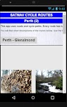
Satnav Cycle Routes – Perth(2) – Click to show
Satnav Cycle Routes – Perth(2)
Ian Lochhead
Perth - Glenalmond. 35 miles Perth - Crieff. 38 miles Perth - Milnathort. 38 miles Satnav Cycle Routes around Perth using cycle paths and roads. Every route has turn-by-turn navigation with voice in…
$0.99
0.0
0+ downloads
|
Maps & Navigation
0.0
$0.99
Ian Lochhead
0+ downloads
TRANSPORTATION
Satnav Cycle Routes – Perth(2)
Perth - Glenalmond. 35 miles Perth - Crieff. 38 miles Perth - Milnathort. 38 miles Satnav Cycle Routes around Perth us…
Toledo Bend RSVR Offline Chart – Click to show
Toledo Bend RSVR Offline Chart
FLYTOMAP INC
Flytomap is a valid and interesting alternative, Featured on the Deck Featured on Geomedia Worldwide Marine and Outdoor Maps available when connected, thanks to viewer.flytomap.com Worldwide Satellit…
$3.99
0.0
100+ downloads
|
Maps & Navigation
0.0
$3.99
FLYTOMAP INC
100+ downloads
TRANSPORTATION
Toledo Bend RSVR Offline Chart
Flytomap is a valid and interesting alternative, Featured on the Deck Featured on Geomedia Worldwide Marine and Outdoor…
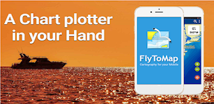
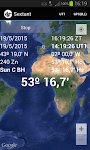
Sextant – This app may contain mature content
Sextant
Navigational Algorithms
Celestial navigation - Astronavigation For training or improving your skills with a marine sextant, an aircraft octant (bubble), an artificial horizon, or a theodolite. - Real time calculation of t…
$1.99
0.0
500+ downloads
|
Maps & Navigation
0.0
$1.99
Navigational Algorithms
500+ downloads
TRANSPORTATION
Sextant
Celestial navigation - Astronavigation For training or improving your skills with a marine sextant, an aircraft octant…
Lake of the Ozarks GPS Charts – Click to show
Lake of the Ozarks GPS Charts
FLYTOMAP INC
Flytomap is a valid and interesting alternative, Featured on the Deck Featured on Geomedia Worldwide Marine and Outdoor Maps available when connected, thanks to viewer.flytomap.com Worldwide Satelli…
$3.99
0.0
100+ downloads
|
Maps & Navigation
0.0
$3.99
FLYTOMAP INC
100+ downloads
TRANSPORTATION
Lake of the Ozarks GPS Charts
Flytomap is a valid and interesting alternative, Featured on the Deck Featured on Geomedia Worldwide Marine and Outdoo…
Mille Lacs Gps Map Navigator – Click to show
Mille Lacs Gps Map Navigator
FLYTOMAP INC
Flytomap is a valid and interesting alternative, Featured on the Deck Featured on Geomedia Worldwide Marine and Outdoor Maps available when connected, thanks to viewer.flytomap.com Worldwide Satelli…
$3.99
0.0
50+ downloads
|
Maps & Navigation
0.0
$3.99
FLYTOMAP INC
50+ downloads
TRANSPORTATION
Mille Lacs Gps Map Navigator
Flytomap is a valid and interesting alternative, Featured on the Deck Featured on Geomedia Worldwide Marine and Outdoo…
Lake Itasca Gps Map Navigator – Click to show
Lake Itasca Gps Map Navigator
FLYTOMAP INC
Flytomap is a valid and interesting alternative, Benetti Yachts Featured on the Deck Featured on Geomedia Worldwide Marine and Outdoor Maps available when connected, thanks to viewer.flytomap.com Wor…
$3.99
0.0
0+ downloads
|
Maps & Navigation
0.0
$3.99
FLYTOMAP INC
0+ downloads
TRANSPORTATION
Lake Itasca Gps Map Navigator
Flytomap is a valid and interesting alternative, Benetti Yachts Featured on the Deck Featured on Geomedia Worldwide Mar…
The Blue Hills Reservation Map – Click to show
The Blue Hills Reservation Map
FLYTOMAP INC
Flytomap is a valid and interesting alternative, Featured on the Deck Featured on Geomedia Try now the new FlyToMap web viewer to see all available maps worldwide !!! Visit viewer.flytomap.com &ldqu…
$3.99
0.0
1+ downloads
|
Maps & Navigation
0.0
$3.99
FLYTOMAP INC
1+ downloads
TRANSPORTATION
The Blue Hills Reservation Map
Flytomap is a valid and interesting alternative, Featured on the Deck Featured on Geomedia Try now the new FlyToMap web…
gibgas CNG Europe
gibgas medien
gibgas proudly presents: THE App for europe-wide mobility with CNG - Compressed Natural Gas. A MUST for every CNG motorist: Always up-to-date and therefore driving safe! This service is unique in Eur…
$4.99
0.0
10,000+ downloads
|
Maps & Navigation
0.0
$4.99
gibgas medien
10,000+ downloads
TRANSPORTATION
gibgas CNG Europe
gibgas proudly presents: THE App for europe-wide mobility with CNG - Compressed Natural Gas. A MUST for every CNG motor…
Delaware Lakes GPS Charts – Click to show
Delaware Lakes GPS Charts
FLYTOMAP INC
Flytomap is a valid and interesting alternative, Featured on the Deck Featured on Geomedia Worldwide Marine and Outdoor Maps available when connected, thanks to viewer.flytomap.com Worldwide Satellit…
$3.99
0.0
0+ downloads
|
Maps & Navigation
0.0
$3.99
FLYTOMAP INC
0+ downloads
TRANSPORTATION
Delaware Lakes GPS Charts
Flytomap is a valid and interesting alternative, Featured on the Deck Featured on Geomedia Worldwide Marine and Outdoor…
Easy Speedometer Pro
Kühne-Webdienste.de
Use this GNSS speedometer with altitude, location, and calculated distances, especially when you are not driving a car but going by bicycle, by train, by boat or even by airplane. You can quickl…
$4.99
0.0
1,000+ downloads
|
Maps & Navigation
0.0
$4.99
Kühne-Webdienste.de
1,000+ downloads
TRANSPORTATION
Easy Speedometer Pro
Use this GNSS speedometer with altitude, location, and calculated distances, especially when you are not driving a car …
Антирадар HUD Speed PRO
AIRBITS & Reactive Phone
Приложение HUD Speed PRO – это цифровой спидометр с функцией предупреждения о превышении ограничения скорости и об опасностях на дороге: камеры, Стрелки, Автодории, Автоураганы, посты и прочее.…
$0.99
4.9
100,000+ downloads
|
Maps & Navigation
4.9
$0.99
AIRBITS & Reactive Phone
100,000+ downloads
TRANSPORTATION
Антирадар HUD Speed PRO
Приложение HUD Speed PRO – это цифровой спидометр с функцией предупреждения о превышении ограничения скорости и о…
Lake Pat-Mayse Texas GPS Map – Click to show
Lake Pat-Mayse Texas GPS Map
FLYTOMAP INC
Flytomap is a valid and interesting alternative, Featured on the Deck Featured on Geomedia Worldwide Marine and Outdoor Maps available when connected, thanks to viewer.flytomap.com Worldwide Satelli…
$3.99
0.0
1+ downloads
|
Maps & Navigation
0.0
$3.99
FLYTOMAP INC
1+ downloads
TRANSPORTATION
Lake Pat-Mayse Texas GPS Map
Flytomap is a valid and interesting alternative, Featured on the Deck Featured on Geomedia Worldwide Marine and Outdoo…
United States
United Kingdom
Germany
Norway
Sweden
Australia
Netherlands
Italy
Denmark
Hong Kong
Brazil
France
Canada
Spain
Portugal
South Korea
Japan
Poland
Hungary
India
Finland
Thailand
Russia
General
Overall
Applications
Games
Join AppBrain
Join AppBrain to get app recommendations
Apps
Art & Design
Auto & Vehicles
Beauty
Books & Reference
Business
Comics
Communication
Dating
Education
Entertainment
Events
Finance
Food & Drink
Health & Fitness
House & Home
Libraries & Demo
Lifestyle
Maps & Navigation
Medical
Music & Audio
News & Magazines
Parenting
Personalization
Photography
Productivity
Shopping
Social
Sports
Tools
Travel & Local
Video Players & Editors
Weather
Games
Action
Adventure
Arcade
Board
Card
Casino
Casual
Educational
Music
Puzzle
Racing
Role Playing
Simulation
Sports Games
Strategy
Trivia
Word