AppBrain
|
Apps
Apps
Apps being viewed right now
Trending apps today
Most popular apps
All-time most downloaded apps
Top rated apps
Statistics
Docs
Developers
Sign up
Log in
Android Apps
>
Maps & Navigation
>
Paid
Category
Maps & Navigation
Sort by
Trending
Recent downloads
All-time downloads
Top rated
Popular in
Filter by
Off
Free
Paid
New
Updated
Price Reduced
No ads
Page 3 of the
popular Paid Maps & Navigation Apps for Android in Poland
Sam Rayburn Offline GPS Charts – Click to show
Sam Rayburn Offline GPS Charts
FLYTOMAP INC
Flytomap is a valid and interesting alternative Worldwide Marine and Outdoor Maps available when connected, thanks to viewer.flytomap.com Worldwide Satellite images overlay on charts Worldwide Terra…
$3.99
0.0
50+ downloads
|
Maps & Navigation
0.0
$3.99
FLYTOMAP INC
50+ downloads
TRANSPORTATION
Sam Rayburn Offline GPS Charts
Flytomap is a valid and interesting alternative Worldwide Marine and Outdoor Maps available when connected, thanks to v…
Next Bus Dublin Pro
Stephen McBride
Next Bus Dublin uses the Dublin Bus realtime information system to tell you exactly when your bus is arriving. No more guessing using fictional timetables! The app is packed with useful features, loo…
$2.49
0.0
1,000+ downloads
|
Maps & Navigation
0.0
$2.49
Stephen McBride
1,000+ downloads
TRANSPORTATION
Next Bus Dublin Pro
Next Bus Dublin uses the Dublin Bus realtime information system to tell you exactly when your bus is arriving. No more …
Light pollution map
Deneb, Jurij Stare, s.p.
Light Pollution Map helps you easily find the darkest places nearby by combining high-resolution VIIRS satellite data with an interactive global map. Explore sky brightness, compare light pollution l…
$5.49
4.3
5,000+ downloads
|
Maps & Navigation
4.3
$5.49
Deneb, Jurij Stare, s.p.
5,000+ downloads
TRANSPORTATION
Light pollution map
Light Pollution Map helps you easily find the darkest places nearby by combining high-resolution VIIRS satellite data w…
Sammamish Lake WA GPS Charts – Click to show
Sammamish Lake WA GPS Charts
FLYTOMAP INC
Flytomap is a valid and interesting alternative, Worldwide Marine and Outdoor Maps available when connected, thanks to viewer.flytomap.com Worldwide Satellite images overlay on charts Worldwide Terr…
$2.99
0.0
1+ downloads
|
Maps & Navigation
0.0
$2.99
FLYTOMAP INC
1+ downloads
TRANSPORTATION
Sammamish Lake WA GPS Charts
Flytomap is a valid and interesting alternative, Worldwide Marine and Outdoor Maps available when connected, thanks to …
Israel Offline Nautical Charts – Click to show
Israel Offline Nautical Charts
MAPITECH LTD
MapiTech launches on the market the best official up-to-date RNC (raster) combined with S57 nautical charts (digital): marinas, wrecks, fishing spots, boat ramps, POI. This app displays seamlessly …
$4.99
0.0
1+ downloads
|
Maps & Navigation
0.0
$4.99
MAPITECH LTD
1+ downloads
TRANSPORTATION
Israel Offline Nautical Charts
MapiTech launches on the market the best official up-to-date RNC (raster) combined with S57 nautical charts (digital):…
Lake Maggiore Offline Charts – Click to show
Lake Maggiore Offline Charts
MAPITECH LTD
MapiTech launches on the market the best official up-to-date RNC (raster) combined with S57 nautical charts (digital): marinas, wrecks, fishing spots, boat ramps, POI. This app displays seamlessly …
$4.99
0.0
50+ downloads
|
Maps & Navigation
0.0
$4.99
MAPITECH LTD
50+ downloads
TRANSPORTATION
Lake Maggiore Offline Charts
MapiTech launches on the market the best official up-to-date RNC (raster) combined with S57 nautical charts (digital):…
MTDash Pro for C-U MTD
Ben Nordick
All the features of MTDash with extra cool stuff: * No ads! * "Go Adventuring" mode that tracks which stops you've been to - can you visit all 1000+? * Double/long buses identified as such…
$0.99
0.0
1+ downloads
|
Maps & Navigation
0.0
$0.99
Ben Nordick
1+ downloads
TRANSPORTATION
MTDash Pro for C-U MTD
All the features of MTDash with extra cool stuff: * No ads! * "Go Adventuring" mode that tracks which stops …
FootPrint
T.creations
Rediscover your steps with FootPrint! See every street you've explored and every path you've taken with this powerful and private GPS logger. FootPrint is your personal travel diary, designed to map …
$3.49
0.0
100+ downloads
|
Maps & Navigation
0.0
$3.49
T.creations
100+ downloads
TRANSPORTATION
FootPrint
Rediscover your steps with FootPrint! See every street you've explored and every path you've taken with this powerful a…
Balaton Lake GPS Map Navigator – Click to show
Balaton Lake GPS Map Navigator
FLYTOMAP INC
Flytomap is a valid and interesting alternative, Worldwide Marine and Outdoor Maps available when connected, thanks to viewer.flytomap.com Worldwide Satellite images overlay on charts Worldwide Terr…
$3.99
0.0
100+ downloads
|
Maps & Navigation
0.0
$3.99
FLYTOMAP INC
100+ downloads
TRANSPORTATION
Balaton Lake GPS Map Navigator
Flytomap is a valid and interesting alternative, Worldwide Marine and Outdoor Maps available when connected, thanks to …
Greenfield Lake - IOWA GPS Map – Click to show
Greenfield Lake - IOWA GPS Map
FLYTOMAP INC
Flytomap is a valid and interesting alternative, Featured on the Deck Featured on Geomedia Worldwide Marine and Outdoor Maps available when connected, thanks to viewer.flytomap.com Worldwide Satellit…
$2.99
0.0
1+ downloads
|
Maps & Navigation
0.0
$2.99
FLYTOMAP INC
1+ downloads
TRANSPORTATION
Greenfield Lake - IOWA GPS Map
Flytomap is a valid and interesting alternative, Featured on the Deck Featured on Geomedia Worldwide Marine and Outdoor…
Spain Atlantic Map Navigator – Click to show
Spain Atlantic Map Navigator
FLYTOMAP INC
Flytomap is a valid and interesting alternative, Featured on the Deck Featured on Geomedia Worldwide Marine and Outdoor Maps available when connected, thanks to viewer.flytomap.com Worldwide Satellit…
$4.99
0.0
10+ downloads
|
Maps & Navigation
0.0
$4.99
FLYTOMAP INC
10+ downloads
TRANSPORTATION
Spain Atlantic Map Navigator
Flytomap is a valid and interesting alternative, Featured on the Deck Featured on Geomedia Worldwide Marine and Outdoor…
Barcelona Benidorm Offline Map – Click to show
Barcelona Benidorm Offline Map
MAPITECH LTD
MapiTech launches on the market the best official up-to-date RNC (raster) combined with S57 nautical charts (digital): marinas, wrecks, fishing spots, boat ramps, POI. This app displays seamlessly …
$4.99
0.0
0+ downloads
|
Maps & Navigation
0.0
$4.99
MAPITECH LTD
0+ downloads
TRANSPORTATION
Barcelona Benidorm Offline Map
MapiTech launches on the market the best official up-to-date RNC (raster) combined with S57 nautical charts (digital):…
Portugal GPS Map Navigator – Click to show
Portugal GPS Map Navigator
FLYTOMAP INC
Flytomap is a valid and interesting alternative, Featured on the Deck Featured on Geomedia Worldwide Marine and Outdoor Maps available when connected, thanks to viewer.flytomap.com Worldwide Satelli…
$3.99
0.0
10+ downloads
|
Maps & Navigation
0.0
$3.99
FLYTOMAP INC
10+ downloads
TRANSPORTATION
Portugal GPS Map Navigator
Flytomap is a valid and interesting alternative, Featured on the Deck Featured on Geomedia Worldwide Marine and Outdoo…
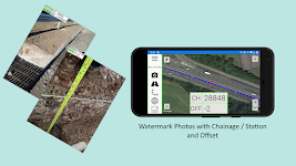
Alignment Viewer
NRG Surveys Ltd
[LEGACY VERSION - NO LONGER UPDATED] Save time with Alignment Viewer – Import a rail or road alignment and receive real-time chainage / station and offset position information. Designed to as…
$16.99
0.0
1,000+ downloads
|
Maps & Navigation
0.0
$16.99
NRG Surveys Ltd
1,000+ downloads
TRANSPORTATION
Alignment Viewer
[LEGACY VERSION - NO LONGER UPDATED] Save time with Alignment Viewer – Import a rail or road alignment and receiv…
East England GPS Map Navigator – Click to show
East England GPS Map Navigator
FLYTOMAP INC
Flytomap is a valid and interesting alternative, Featured on the Deck Featured on Geomedia Worldwide Marine and Outdoor Maps available when connected, thanks to viewer.flytomap.com Worldwide Satellit…
$5.99
0.0
0+ downloads
|
Maps & Navigation
0.0
$5.99
FLYTOMAP INC
0+ downloads
TRANSPORTATION
East England GPS Map Navigator
Flytomap is a valid and interesting alternative, Featured on the Deck Featured on Geomedia Worldwide Marine and Outdoor…
Navigation Companion - G Maps – Click to show
Navigation Companion - G Maps
Mobiteka
This is a route planner (host application) for Navigation Companion app that runs on smartwatches. Prerequisites: • Only phones with Google Play Services are supported • Application wor…
$2.99
0.0
1,000+ downloads
|
Maps & Navigation
0.0
$2.99
Mobiteka
1,000+ downloads
TRANSPORTATION
Navigation Companion - G Maps
This is a route planner (host application) for Navigation Companion app that runs on smartwatches. Prerequisites: &bu…
Costa Brava GPS Map Navigator – Click to show
Costa Brava GPS Map Navigator
FLYTOMAP INC
Flytomap is a valid and interesting alternative, Featured on the Deck Featured on Geomedia Worldwide Marine and Outdoor Maps available when connected, thanks to viewer.flytomap.com Worldwide Satellit…
$3.99
0.0
5+ downloads
|
Maps & Navigation
0.0
$3.99
FLYTOMAP INC
5+ downloads
TRANSPORTATION
Costa Brava GPS Map Navigator
Flytomap is a valid and interesting alternative, Featured on the Deck Featured on Geomedia Worldwide Marine and Outdoor…
Lake of the Ozarks GPS Charts – Click to show
Lake of the Ozarks GPS Charts
FLYTOMAP INC
Flytomap is a valid and interesting alternative, Featured on the Deck Featured on Geomedia Worldwide Marine and Outdoor Maps available when connected, thanks to viewer.flytomap.com Worldwide Satelli…
$3.99
0.0
100+ downloads
|
Maps & Navigation
0.0
$3.99
FLYTOMAP INC
100+ downloads
TRANSPORTATION
Lake of the Ozarks GPS Charts
Flytomap is a valid and interesting alternative, Featured on the Deck Featured on Geomedia Worldwide Marine and Outdoo…
OBD Info-san!
ganchi
note: The text translates the original Japanese with a Google translation. [Operation check in the trial version! 】 Although this application is charged, there is a possibility that it will not oper…
$4.99
0.0
5,000+ downloads
|
Maps & Navigation
0.0
$4.99
ganchi
5,000+ downloads
TRANSPORTATION
OBD Info-san!
note: The text translates the original Japanese with a Google translation. [Operation check in the trial version! 】 Al…
Helsinki GPS Map Navigator – Click to show
Helsinki GPS Map Navigator
FLYTOMAP INC
Flytomap is a valid and interesting alternative, Featured on the Deck Featured on Geomedia Worldwide Marine and Outdoor Maps available when connected, thanks to viewer.flytomap.com Worldwide Satelli…
$3.99
0.0
5+ downloads
|
Maps & Navigation
0.0
$3.99
FLYTOMAP INC
5+ downloads
TRANSPORTATION
Helsinki GPS Map Navigator
Flytomap is a valid and interesting alternative, Featured on the Deck Featured on Geomedia Worldwide Marine and Outdoo…
United States
United Kingdom
Germany
Norway
Sweden
Australia
Netherlands
Italy
Denmark
Hong Kong
Brazil
France
Canada
Spain
Portugal
South Korea
Japan
Poland
Hungary
India
Finland
Thailand
Russia
General
Overall
Applications
Games
Join AppBrain
Join AppBrain to get app recommendations
Apps
Art & Design
Auto & Vehicles
Beauty
Books & Reference
Business
Comics
Communication
Dating
Education
Entertainment
Events
Finance
Food & Drink
Health & Fitness
House & Home
Libraries & Demo
Lifestyle
Maps & Navigation
Medical
Music & Audio
News & Magazines
Parenting
Personalization
Photography
Productivity
Shopping
Social
Sports
Tools
Travel & Local
Video Players & Editors
Weather
Games
Action
Adventure
Arcade
Board
Card
Casino
Casual
Educational
Music
Puzzle
Racing
Role Playing
Simulation
Sports Games
Strategy
Trivia
Word