Android Apps
>
Maps & Navigation
> Paid
Category
Maps & Navigation
Sort by
Trending
Recent downloads
All-time downloads
Top rated
Popular in
Filter by
Off
Free
Paid
New
Updated
Price Reduced
No ads
Page 7 of the popular Paid Maps & Navigation Apps for Android in Russia
SG BusLeh Full Unlock
OriginallyUS.SG - Award Winning App Consultancy

NOTE 1: BusLeh Unlock does not currently remove BusLeh announcements, which may contain important announcements such as traffic breakdown, data service breakdown, as well as text-based deals and offe…


$74.99
0.0
1,000+ downloads
|
Maps & Navigation
0.0
$74.99
OriginallyUS.SG - Award Winning App Consultancy
1,000+ downloads
TRANSPORTATION
1,000+ downloads
TRANSPORTATION
SG BusLeh Full Unlock
NOTE 1: BusLeh Unlock does not currently remove BusLeh announcements, which may contain important announcements such as…
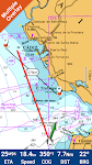
Lake Pend Oreille Idaho Charts
MAPITECH LTD

MapiTech launches on the market the best official up-to-date NOAA RNC (raster) combined with S57 nautical charts (digital): marinas, wrecks, fishing spots, boat ramps, POI.
This app displays seamles…


$4.99
0.0
1+ downloads
|
Maps & Navigation
0.0
$4.99
MAPITECH LTD
1+ downloads
TRANSPORTATION
1+ downloads
TRANSPORTATION
Lake Pend Oreille Idaho Charts
MapiTech launches on the market the best official up-to-date NOAA RNC (raster) combined with S57 nautical charts (digit…
Lake Leman Geneva Offline Maps
FLYTOMAP INC

Flytomap is a valid and interesting alternative,
Featured on the Deck
Featured on Geomedia
Worldwide Marine and Outdoor Maps available when connected, thanks to viewer.flytomap.com
Worldwide Satelli…


$3.99
0.0
100+ downloads
|
Maps & Navigation
0.0
$3.99
FLYTOMAP INC
100+ downloads
TRANSPORTATION
100+ downloads
TRANSPORTATION
Lake Leman Geneva Offline Maps
Flytomap is a valid and interesting alternative,
Featured on the Deck
Featured on Geomedia
Worldwide Marine and Outdoo…
Lake Chiemsee GPS Navigator
FLYTOMAP INC

Flytomap is a valid and interesting alternative,
Featured on the Deck
Featured on Geomedia
Worldwide Marine and Outdoor Maps available when connected, thanks to viewer.flytomap.com
Worldwide Satelli…


$3.99
0.0
10+ downloads
|
Maps & Navigation
0.0
$3.99
FLYTOMAP INC
10+ downloads
TRANSPORTATION
10+ downloads
TRANSPORTATION
Lake Chiemsee GPS Navigator
Flytomap is a valid and interesting alternative,
Featured on the Deck
Featured on Geomedia
Worldwide Marine and Outdoo…
Galveston to Rio Grande Charts
MAPITECH LTD

MapiTech launches on the market the best official up-to-date NOAA RNC (raster) combined with S57 nautical charts (digital): marinas, wrecks, fishing spots, boat ramps, POI.
This app displays seamles…


$4.99
0.0
0+ downloads
|
Maps & Navigation
0.0
$4.99
MAPITECH LTD
0+ downloads
TRANSPORTATION
0+ downloads
TRANSPORTATION
Galveston to Rio Grande Charts
MapiTech launches on the market the best official up-to-date NOAA RNC (raster) combined with S57 nautical charts (digit…
Lake Wakatipu NZ Offline Chart
MAPITECH LTD

MapiTech launches on the market the best official up-to-date NOAA RNC (raster) combined with S57 nautical charts (digital): marinas, wrecks, fishing spots, boat ramps, POI.
This app displays seamles…


$4.99
0.0
0+ downloads
|
Maps & Navigation
0.0
$4.99
MAPITECH LTD
0+ downloads
TRANSPORTATION
0+ downloads
TRANSPORTATION
Lake Wakatipu NZ Offline Chart
MapiTech launches on the market the best official up-to-date NOAA RNC (raster) combined with S57 nautical charts (digit…
Spain Mediterranean GPS Charts
FLYTOMAP INC

Flytomap is a valid and interesting alternative,
Featured on the Deck
Featured on Geomedia
Worldwide Marine and Outdoor Maps available when connected, thanks to viewer.flytomap.com
Worldwide Satellit…


$4.99
0.0
50+ downloads
|
Maps & Navigation
0.0
$4.99
FLYTOMAP INC
50+ downloads
TRANSPORTATION
50+ downloads
TRANSPORTATION
Spain Mediterranean GPS Charts
Flytomap is a valid and interesting alternative,
Featured on the Deck
Featured on Geomedia
Worldwide Marine and Outdoor…
Potomac River Was GPS Charts
FLYTOMAP INC

Flytomap is a valid and interesting alternative,
Worldwide Marine and Outdoor Maps available when connected, thanks to viewer.flytomap.com
Worldwide Satellite images overlay on charts
Worldwide Ter…

$2.99
0.0
10+ downloads
|
Maps & Navigation
0.0
$2.99
FLYTOMAP INC
10+ downloads
TRANSPORTATION
10+ downloads
TRANSPORTATION
Potomac River Was GPS Charts
Flytomap is a valid and interesting alternative,
Worldwide Marine and Outdoor Maps available when connected, thanks to…
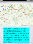
Satnav Cycle Routes – Falkirk
Ian Lochhead

Around the Falkirk Wheel. 12.5 miles
Falkirk - Avonbridge. 24 miles
Falkirk - Fannyside Loch. 20 miles
Falkirk Wheel & Helix Park. 12 miles
Satnav Cycle Routes around Falkirk using cycle paths a…


$0.99
0.0
0+ downloads
|
Maps & Navigation
0.0
$0.99
Ian Lochhead
0+ downloads
TRANSPORTATION
0+ downloads
TRANSPORTATION
Satnav Cycle Routes – Falkirk
Around the Falkirk Wheel. 12.5 miles
Falkirk - Avonbridge. 24 miles
Falkirk - Fannyside Loch. 20 miles
Falkirk Wheel &a…
Cng/Lpg Finder EUR&US&CAN +
Lepus

Cng/Lpg Finder Plus is a route planner and a tool for finding compressed natural gas (Cng) or liquified petroleum gas (Lpg) stations along the route or around a location. It supports Lpg and Cng sta…


$5.00
0.0
1,000+ downloads
|
Maps & Navigation
0.0
$5.00
Lepus
1,000+ downloads
TRANSPORTATION
1,000+ downloads
TRANSPORTATION
Cng/Lpg Finder EUR&US&CAN +
Cng/Lpg Finder Plus is a route planner and a tool for finding compressed natural gas (Cng) or liquified petroleum gas …
Andalusia GPS Map Navigator
FLYTOMAP INC

Flytomap is a valid and interesting alternative,
Featured on the Deck
Featured on Geomedia
Worldwide Marine and Outdoor Maps available when connected, thanks to viewer.flytomap.com
Worldwide Satellit…

$3.99
0.0
10+ downloads
|
Maps & Navigation
0.0
$3.99
FLYTOMAP INC
10+ downloads
TRANSPORTATION
10+ downloads
TRANSPORTATION
Andalusia GPS Map Navigator
Flytomap is a valid and interesting alternative,
Featured on the Deck
Featured on Geomedia
Worldwide Marine and Outdoor…
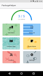
PackageHelper
Netsyms Technologies

Tired of scanning "leftover" Amazon boxes no access? Need to focus your attention on avoiding animal interference? Don't want to worry about finding that white SPR full of pills when you'…

$1.99
4.8
100+ downloads
|
Maps & Navigation
4.8
$1.99
Netsyms Technologies
100+ downloads
TRANSPORTATION
100+ downloads
TRANSPORTATION
PackageHelper
Tired of scanning "leftover" Amazon boxes no access? Need to focus your attention on avoiding animal interfe…
Lake Ahquabi - IOWA GPS Map
FLYTOMAP INC

Flytomap is a valid and interesting alternative,
Worldwide Marine and Outdoor Maps available when connected, thanks to viewer.flytomap.com
Worldwide Satellite images overlay on charts
Worldwide Ter…

$1.99
0.0
0+ downloads
|
Maps & Navigation
0.0
$1.99
FLYTOMAP INC
0+ downloads
TRANSPORTATION
0+ downloads
TRANSPORTATION
Lake Ahquabi - IOWA GPS Map
Flytomap is a valid and interesting alternative,
Worldwide Marine and Outdoor Maps available when connected, thanks to…
UK Ireland GPS Map Navigator
FLYTOMAP INC

Flytomap is a valid and interesting alternative,
Featured on the Deck
Featured on Geomedia
Worldwide Marine and Outdoor Maps available when connected, thanks to viewer.flytomap.com
Worldwide Satellit…


$4.99
0.0
10+ downloads
|
Maps & Navigation
0.0
$4.99
FLYTOMAP INC
10+ downloads
TRANSPORTATION
10+ downloads
TRANSPORTATION
UK Ireland GPS Map Navigator
Flytomap is a valid and interesting alternative,
Featured on the Deck
Featured on Geomedia
Worldwide Marine and Outdoor…
Satnav Cycle Routes -Dundee(2)
Ian Lochhead

Dundee - Piperdam. 23 miles
Dundee - Carnoustie. 31 miles
Satnav Cycle Routes around Dundee using cycle paths and roads. Every route has turn-by-turn navigation with voice instruction. Enjoy the ben…


$0.99
0.0
0+ downloads
|
Maps & Navigation
0.0
$0.99
Ian Lochhead
0+ downloads
TRANSPORTATION
0+ downloads
TRANSPORTATION
Satnav Cycle Routes -Dundee(2)
Dundee - Piperdam. 23 miles
Dundee - Carnoustie. 31 miles
Satnav Cycle Routes around Dundee using cycle paths and road…
PRO Voice Navigator "IGH"
rausNT

This app is a voice-based navigator.
"I'm going home" is primarily intended for trekking enthusiasts, since it's
a navigator for cross-country conditions. If you are afraid of getting lost…


$2.99
5.0
10,000+ downloads
|
Maps & Navigation
5.0
$2.99
rausNT
10,000+ downloads
TRANSPORTATION
10,000+ downloads
TRANSPORTATION
PRO Voice Navigator "IGH"
This app is a voice-based navigator.
"I'm going home" is primarily intended for trekking enthusiasts, since …
Pickwick Lake Al GPS Charts
FLYTOMAP INC

Flytomap is a valid and interesting alternative,
Featured on the Deck
Featured on Geomedia
Worldwide Marine and Outdoor Maps available when connected, thanks to viewer.flytomap.com
Worldwide Satelli…


$2.99
0.0
1+ downloads
|
Maps & Navigation
0.0
$2.99
FLYTOMAP INC
1+ downloads
TRANSPORTATION
1+ downloads
TRANSPORTATION
Pickwick Lake Al GPS Charts
Flytomap is a valid and interesting alternative,
Featured on the Deck
Featured on Geomedia
Worldwide Marine and Outdoo…
Madeira Island Offline Charts
MAPITECH LTD

MapiTech launches on the market the best official up-to-date RNC (raster) combined with S57 nautical charts (digital): marinas, wrecks, fishing spots, boat ramps, POI.
This app displays seamlessly …


$4.99
0.0
10+ downloads
|
Maps & Navigation
0.0
$4.99
MAPITECH LTD
10+ downloads
TRANSPORTATION
10+ downloads
TRANSPORTATION
Madeira Island Offline Charts
MapiTech launches on the market the best official up-to-date RNC (raster) combined with S57 nautical charts (digital):…
Tims Ford Lake TN Offline Maps
MAPITECH LTD

MapiTech launches on the market the best official up-to-date RNC (raster) combined with S57 nautical charts (digital): marinas, wrecks, fishing spots, boat ramps, POI.
This app displays seamlessly …


$4.99
0.0
1+ downloads
|
Maps & Navigation
0.0
$4.99
MAPITECH LTD
1+ downloads
TRANSPORTATION
1+ downloads
TRANSPORTATION
Tims Ford Lake TN Offline Maps
MapiTech launches on the market the best official up-to-date RNC (raster) combined with S57 nautical charts (digital):…
Cayuga Seneca Lakes GPS Charts
MAPITECH LTD

MapiTech launches on the market the best official up-to-date NOAA RNC (raster) combined with S57 nautical charts (digital): marinas, wrecks, fishing spots, boat ramps, POI.
This app displays seamles…


$4.99
0.0
0+ downloads
|
Maps & Navigation
0.0
$4.99
MAPITECH LTD
0+ downloads
TRANSPORTATION
0+ downloads
TRANSPORTATION
Cayuga Seneca Lakes GPS Charts
MapiTech launches on the market the best official up-to-date NOAA RNC (raster) combined with S57 nautical charts (digit…
More apps
Android Statistics
© 2010-2024 - AppBrain