Android Apps
>
Maps & Navigation
> Paid
Category
Maps & Navigation
Sort by
Trending
Recent downloads
All-time downloads
Top rated
Popular in
Filter by
Off
Free
Paid
New
Updated
Price Reduced
No ads
Page 10 of the popular Paid Maps & Navigation Apps for Android in Russia
Caltrain Commuter
Noah Listgarten

Caltrain Commuter is the best app for commuters on Caltrain.
- Set up your commute and your watched trains
- Customize your notifications.
- See Caltrain’s status, system-wide and specific aler…


$3.99
0.0
10+ downloads
|
Maps & Navigation
0.0
$3.99
Noah Listgarten
10+ downloads
TRANSPORTATION
10+ downloads
TRANSPORTATION
Caltrain Commuter
Caltrain Commuter is the best app for commuters on Caltrain.
- Set up your commute and your watched trains
- Customize …
Folsom Lake CA Offline Charts
MAPITECH LTD

MapiTech launches on the market the best official up-to-date NOAA RNC (raster) combined with S57 nautical charts (digital): marinas, wrecks, fishing spots, boat ramps, POI.
This app displays seamles…


$4.99
0.0
0+ downloads
|
Maps & Navigation
0.0
$4.99
MAPITECH LTD
0+ downloads
TRANSPORTATION
0+ downloads
TRANSPORTATION
Folsom Lake CA Offline Charts
MapiTech launches on the market the best official up-to-date NOAA RNC (raster) combined with S57 nautical charts (digit…
Aeolian Islands Offline Chart
MAPITECH LTD

MapiTech launches on the market the best official up-to-date RNC (raster) combined with S57 nautical charts (digital): marinas, wrecks, fishing spots, boat ramps, POI.
This app displays seamlessly …


$4.99
0.0
1+ downloads
|
Maps & Navigation
0.0
$4.99
MAPITECH LTD
1+ downloads
TRANSPORTATION
1+ downloads
TRANSPORTATION
Aeolian Islands Offline Chart
MapiTech launches on the market the best official up-to-date RNC (raster) combined with S57 nautical charts (digital):…
Elba GPS Map Navigator
FLYTOMAP INC

Flytomap is a valid and interesting alternative,
Featured on the Deck
Featured on Geomedia
Worldwide Marine and Outdoor Maps available when connected, thanks to viewer.flytomap.com
Worldwide Satellit…


$3.99
0.0
10+ downloads
|
Maps & Navigation
0.0
$3.99
FLYTOMAP INC
10+ downloads
TRANSPORTATION
10+ downloads
TRANSPORTATION
Elba GPS Map Navigator
Flytomap is a valid and interesting alternative,
Featured on the Deck
Featured on Geomedia
Worldwide Marine and Outdoor…
Find My Device(Imei Tracker)
CodeEr

Find My Device (Imei Tracker) is the essential tracking tool for anyone who has experienced the stress, worry, and inconvenience associated with a lost or stolen device. What’s more, it’s…


$23.99
1.0
1,000+ downloads
|
Maps & Navigation
1.0
$23.99
CodeEr
1,000+ downloads
TRANSPORTATION
1,000+ downloads
TRANSPORTATION
Find My Device(Imei Tracker)
Find My Device (Imei Tracker) is the essential tracking tool for anyone who has experienced the stress, worry, and inco…
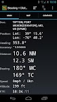
Bearing + Distance
Dan Finkelstein

Created just for private pilots, B+D puts a complete database of every public airport, VOR, NDB, Waypoint, and major Reporting Point in your pocket. Pick one, and instantly get the Bearing (true + m…


$5.99
0.0
100+ downloads
|
Maps & Navigation
0.0
$5.99
Dan Finkelstein
100+ downloads
TRANSPORTATION
100+ downloads
TRANSPORTATION
Bearing + Distance
Created just for private pilots, B+D puts a complete database of every public airport, VOR, NDB, Waypoint, and major Re…
Lake Pahoja IOWA GPS Charts
FLYTOMAP INC

Flytomap is a valid and interesting alternative
Featured on the Deck
Featured on Geomedia
Worldwide Marine and Outdoor Maps available when connected, thanks to viewer.flytomap.com
Worldwide Satellite…


$1.99
0.0
1+ downloads
|
Maps & Navigation
0.0
$1.99
FLYTOMAP INC
1+ downloads
TRANSPORTATION
1+ downloads
TRANSPORTATION
Lake Pahoja IOWA GPS Charts
Flytomap is a valid and interesting alternative
Featured on the Deck
Featured on Geomedia
Worldwide Marine and Outdoor …
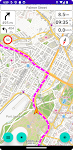
BMaps Navigation
Boonhut

BMaps Navigation – Offline GPS for All Routes
New: BMaps now supports Android Auto!
Never get lost again! BMaps Navigation allows you to navigate any GPX track or create custom routes for ca…


$9.99
0.0
10+ downloads
|
Maps & Navigation
0.0
$9.99
Boonhut
10+ downloads
TRANSPORTATION
10+ downloads
TRANSPORTATION
BMaps Navigation
BMaps Navigation – Offline GPS for All Routes
New: BMaps now supports Android Auto!
Never get lost again! BMap…
Galicia Offline Nautical Chart
MAPITECH LTD

MapiTech launches on the market the best official up-to-date RNC (raster) combined with S57 nautical charts (digital): marinas, wrecks, fishing spots, boat ramps, POI.
This app displays seamlessly …


$4.99
0.0
1+ downloads
|
Maps & Navigation
0.0
$4.99
MAPITECH LTD
1+ downloads
TRANSPORTATION
1+ downloads
TRANSPORTATION
Galicia Offline Nautical Chart
MapiTech launches on the market the best official up-to-date RNC (raster) combined with S57 nautical charts (digital):…
National Forests Map Guide USA
GeoPOI LLC

The United States of America is a vast land full of lush forests, indescribable landscapes, and fascinating history. You may already know some of the iconic landmarks and wildernesses that the US has…


$1.49
3.2
500+ downloads
|
Maps & Navigation
3.2
$1.49
GeoPOI LLC
500+ downloads
TRANSPORTATION
500+ downloads
TRANSPORTATION
National Forests Map Guide USA
The United States of America is a vast land full of lush forests, indescribable landscapes, and fascinating history. Yo…
Aegean Sea GPS Map Navigator
FLYTOMAP INC

Flytomap is a valid and interesting alternative,
Featured on the Deck
Featured on Geomedia
Worldwide Marine and Outdoor Maps available when connected, thanks to viewer.flytomap.com
Worldwide Satellit…


$3.99
0.0
50+ downloads
|
Maps & Navigation
0.0
$3.99
FLYTOMAP INC
50+ downloads
TRANSPORTATION
50+ downloads
TRANSPORTATION
Aegean Sea GPS Map Navigator
Flytomap is a valid and interesting alternative,
Featured on the Deck
Featured on Geomedia
Worldwide Marine and Outdoor…
Satnav Cycle Routes – Falkland
Ian Lochhead

Satnav Cycle Route from Falkland to Loch Leven using cycle paths and roads. The route has turn-by-turn navigation with voice instruction. Enjoy the benefits of cycling a whole route by following Sat …


$0.99
0.0
0+ downloads
|
Maps & Navigation
0.0
$0.99
Ian Lochhead
0+ downloads
TRANSPORTATION
0+ downloads
TRANSPORTATION
Satnav Cycle Routes – Falkland
Satnav Cycle Route from Falkland to Loch Leven using cycle paths and roads. The route has turn-by-turn navigation with …
Walen See Offline GPS Charts
MAPITECH LTD

MapiTech launches on the market the best official up-to-date RNC (raster) combined with S57 nautical charts (digital): marinas, wrecks, fishing spots, boat ramps, POI.
This app displays seamlessly …


$4.99
0.0
10+ downloads
|
Maps & Navigation
0.0
$4.99
MAPITECH LTD
10+ downloads
TRANSPORTATION
10+ downloads
TRANSPORTATION
Walen See Offline GPS Charts
MapiTech launches on the market the best official up-to-date RNC (raster) combined with S57 nautical charts (digital):…
Lake Zug - Aegeri GPS Charts
FLYTOMAP INC

Flytomap is a valid and interesting alternative,
Featured on the Deck
Featured on Geomedia
Worldwide Marine and Outdoor Maps available when connected, thanks to viewer.flytomap.com
Worldwide Satelli…


$3.99
0.0
1+ downloads
|
Maps & Navigation
0.0
$3.99
FLYTOMAP INC
1+ downloads
TRANSPORTATION
1+ downloads
TRANSPORTATION
Lake Zug - Aegeri GPS Charts
Flytomap is a valid and interesting alternative,
Featured on the Deck
Featured on Geomedia
Worldwide Marine and Outdoo…
Ingham Lake - IOWA GPS Map
FLYTOMAP INC

Flytomap is a valid and interesting alternative,
Featured on the Deck
Featured on Geomedia
Worldwide Marine and Outdoor Maps available when connected, thanks to viewer.flytomap.com
Worldwide Satelli…


$2.99
0.0
0+ downloads
|
Maps & Navigation
0.0
$2.99
FLYTOMAP INC
0+ downloads
TRANSPORTATION
0+ downloads
TRANSPORTATION
Ingham Lake - IOWA GPS Map
Flytomap is a valid and interesting alternative,
Featured on the Deck
Featured on Geomedia
Worldwide Marine and Outdoo…
Snowdonia Outdoor Map Offline
jonathan shutt

An offline map of the Snowdonia National Park in Wales, ideal for hiking, running, mountain biking / cycling. Being offline means unlike other map apps, you don't need a signal to access detailed map…


$1.99
0.0
100+ downloads
|
Maps & Navigation
0.0
$1.99
jonathan shutt
100+ downloads
TRANSPORTATION
100+ downloads
TRANSPORTATION
Snowdonia Outdoor Map Offline
An offline map of the Snowdonia National Park in Wales, ideal for hiking, running, mountain biking / cycling. Being off…
Barcelona Offline GPS Charts
MAPITECH LTD

MapiTech launches on the market the best official up-to-date RNC (raster) combined with S57 nautical charts (digital): marinas, wrecks, fishing spots, boat ramps, POI.
This app displays seamlessly …


$4.99
0.0
0+ downloads
|
Maps & Navigation
0.0
$4.99
MAPITECH LTD
0+ downloads
TRANSPORTATION
0+ downloads
TRANSPORTATION
Barcelona Offline GPS Charts
MapiTech launches on the market the best official up-to-date RNC (raster) combined with S57 nautical charts (digital):…
Oregon SW Mushroom Forager Map
GeoPOI LLC

The forests and woodlands of the Pacific Northwest are ecosystems rich with edible wild mushrooms if you know where to look. Trouble is, seasoned wild edible collectors seldom share their 'honey hole…


$1.49
0.0
0+ downloads
|
Maps & Navigation
0.0
$1.49
GeoPOI LLC
0+ downloads
TRANSPORTATION
0+ downloads
TRANSPORTATION
Oregon SW Mushroom Forager Map
The forests and woodlands of the Pacific Northwest are ecosystems rich with edible wild mushrooms if you know where to …
Bejaia Tabarka Offline Charts
MAPITECH LTD

MapiTech launches on the market the best official up-to-date RNC (raster) combined with S57 nautical charts (digital): marinas, wrecks, fishing spots, boat ramps, POI.
This app displays seamlessly …


$4.99
0.0
0+ downloads
|
Maps & Navigation
0.0
$4.99
MAPITECH LTD
0+ downloads
TRANSPORTATION
0+ downloads
TRANSPORTATION
Bejaia Tabarka Offline Charts
MapiTech launches on the market the best official up-to-date RNC (raster) combined with S57 nautical charts (digital):…
Hebrides GPS Map Navigator
FLYTOMAP INC

Flytomap is a valid and interesting alternative,
Featured on the Deck
Featured on Geomedia
Worldwide Marine and Outdoor Maps available when connected, thanks to viewer.flytomap.com
Worldwide Satelli…


$3.99
0.0
1+ downloads
|
Maps & Navigation
0.0
$3.99
FLYTOMAP INC
1+ downloads
TRANSPORTATION
1+ downloads
TRANSPORTATION
Hebrides GPS Map Navigator
Flytomap is a valid and interesting alternative,
Featured on the Deck
Featured on Geomedia
Worldwide Marine and Outdoo…
Android Statistics
© 2010-2024 - AppBrain