AppBrain
|
Apps
Apps
Apps being viewed right now
Trending apps today
Most popular apps
All-time most downloaded apps
Top rated apps
Statistics
Docs
Developers
Sign up
Log in
Android Apps
>
Maps & Navigation
>
Paid
Category
Maps & Navigation
Sort by
Trending
Recent downloads
All-time downloads
Top rated
Popular in
Filter by
Off
Free
Paid
New
Updated
Price Reduced
No ads
Page 3 of the
popular Paid Maps & Navigation Apps for Android in Russia
Mallorca Menorca Offline Chart – Click to show
Mallorca Menorca Offline Chart
MAPITECH LTD
MapiTech launches on the market the best official up-to-date RNC (raster) combined with S57 nautical charts (digital): marinas, wrecks, fishing spots, boat ramps, POI. This app displays seamlessly …
$4.99
0.0
1+ downloads
|
Maps & Navigation
0.0
$4.99
MAPITECH LTD
1+ downloads
TRANSPORTATION
Mallorca Menorca Offline Chart
MapiTech launches on the market the best official up-to-date RNC (raster) combined with S57 nautical charts (digital):…
Yorkshire Dales Outdoor Map Pr – Click to show
Yorkshire Dales Outdoor Map Pr
jonathan shutt
An offline map of the Yorkshire Dales National Park in England, ideal for hiking, running, mountain biking / cycling. Being offline means unlike other map apps, you don't need a signal to access deta…
$1.99
0.0
100+ downloads
|
Maps & Navigation
0.0
$1.99
jonathan shutt
100+ downloads
TRANSPORTATION
Yorkshire Dales Outdoor Map Pr
An offline map of the Yorkshire Dales National Park in England, ideal for hiking, running, mountain biking / cycling. B…
Manhattan Fallout Shelters Map – Click to show
Manhattan Fallout Shelters Map
GeoPOI LLC
Navigate an interactive map of nearly 25,000 points representing the locations of surveyed nuclear fallout shelters across the entirety of Manhattan Island in New York City. This includes all of the …
$3.99
0.0
0+ downloads
|
Maps & Navigation
0.0
$3.99
GeoPOI LLC
0+ downloads
TRANSPORTATION
Manhattan Fallout Shelters Map
Navigate an interactive map of nearly 25,000 points representing the locations of surveyed nuclear fallout shelters acr…
Lake Vanern GPS Fishing Charts – Click to show
Lake Vanern GPS Fishing Charts
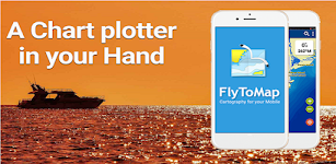
FLYTOMAP INC
Flytomap is a valid and interesting alternative, Worldwide Marine and Outdoor Maps available when connected, thanks to viewer.flytomap.com Worldwide Satellite images overlay on charts Worldwide Ter…
$3.99
0.0
10+ downloads
|
Maps & Navigation
0.0
$3.99
FLYTOMAP INC
10+ downloads
TRANSPORTATION
Lake Vanern GPS Fishing Charts
Flytomap is a valid and interesting alternative, Worldwide Marine and Outdoor Maps available when connected, thanks to…
PgW Navigation App
Aerotools
This application is a navigation assistant which provides useful information about all the airports and navaids located around you (40Nm range max). Directly on your watch, with your location informa…
$15.99
0.0
100+ downloads
|
Maps & Navigation
0.0
$15.99
Aerotools
100+ downloads
TRANSPORTATION
PgW Navigation App
This application is a navigation assistant which provides useful information about all the airports and navaids located…
Ceuta GPS Map Navigator – Click to show
Ceuta GPS Map Navigator
FLYTOMAP INC
Flytomap is a valid and interesting alternative, Featured on the Deck Featured on Geomedia Worldwide Marine and Outdoor Maps available when connected, thanks to viewer.flytomap.com Worldwide Satellit…
$3.99
0.0
5+ downloads
|
Maps & Navigation
0.0
$3.99
FLYTOMAP INC
5+ downloads
TRANSPORTATION
Ceuta GPS Map Navigator
Flytomap is a valid and interesting alternative, Featured on the Deck Featured on Geomedia Worldwide Marine and Outdoor…
Forager's Buddy Pro Key
G.H IT Services
This product is the Activation Code of Forager's Buddy. Once purchased, you can upgrade Forager's Buddy Free version to Forager's Buddy Pro version. You must have Forager's Buddy Free Edition insta…
$2.99
4.4
1,000+ downloads
|
Maps & Navigation
4.4
$2.99
G.H IT Services
1,000+ downloads
TRANSPORTATION
Forager's Buddy Pro Key
This product is the Activation Code of Forager's Buddy. Once purchased, you can upgrade Forager's Buddy Free version to…
Lake Joe Pool Texas GPS Charts – Click to show
Lake Joe Pool Texas GPS Charts
FLYTOMAP INC
Flytomap is a valid and interesting alternative, Featured on the Deck Featured on Geomedia Worldwide Marine and Outdoor Maps available when connected, thanks to viewer.flytomap.com Worldwide Satelli…
$3.99
0.0
5+ downloads
|
Maps & Navigation
0.0
$3.99
FLYTOMAP INC
5+ downloads
TRANSPORTATION
Lake Joe Pool Texas GPS Charts
Flytomap is a valid and interesting alternative, Featured on the Deck Featured on Geomedia Worldwide Marine and Outdoo…
Speedometer
Mykola Drozd
Good and easy to use speedometer, pedometer, route tracker. Convenient for sports, fitness, hiking, traveling and other purposes when you need to know about your speed and location. Allows you to sa…
$1.49
0.0
50+ downloads
|
Maps & Navigation
0.0
$1.49
Mykola Drozd
50+ downloads
TRANSPORTATION
Speedometer
Good and easy to use speedometer, pedometer, route tracker. Convenient for sports, fitness, hiking, traveling and other…
Starry Starry Day Professional
Mapsoft
Starry Starry Day Pro allows the daytime use of a total station to rapidly obtain highly accurate True and Grid North azimuths to astro objects without needing an internet connection. Brief Usage In…
$0.49
0.0
10+ downloads
|
Maps & Navigation
0.0
$0.49
Mapsoft
10+ downloads
TRANSPORTATION
Starry Starry Day Professional
Starry Starry Day Pro allows the daytime use of a total station to rapidly obtain highly accurate True and Grid North a…
Georgia S to N Carolina Charts – Click to show
Georgia S to N Carolina Charts
FLYTOMAP INC
Flytomap is a valid and interesting alternative, Featured on the Deck Featured on Geomedia Worldwide Marine and Outdoor Maps available when connected, thanks to viewer.flytomap.com Worldwide Satellit…
$3.99
0.0
0+ downloads
|
Maps & Navigation
0.0
$3.99
FLYTOMAP INC
0+ downloads
TRANSPORTATION
Georgia S to N Carolina Charts
Flytomap is a valid and interesting alternative, Featured on the Deck Featured on Geomedia Worldwide Marine and Outdoor…
Stora Le sjö Offline GPS Karta – Click to show
Stora Le sjö Offline GPS Karta
MAPITECH LTD
MapiTech launches on the market the best official up-to-date RNC (raster) combined with S57 nautical charts (digital): marinas, wrecks, fishing spots, boat ramps, POI. This app displays seamlessly …
$4.99
0.0
10+ downloads
|
Maps & Navigation
0.0
$4.99
MAPITECH LTD
10+ downloads
TRANSPORTATION
Stora Le sjö Offline GPS Karta
MapiTech launches on the market the best official up-to-date RNC (raster) combined with S57 nautical charts (digital):…
Mille Lacs Gps Map Navigator – Click to show
Mille Lacs Gps Map Navigator
FLYTOMAP INC
Flytomap is a valid and interesting alternative, Featured on the Deck Featured on Geomedia Worldwide Marine and Outdoor Maps available when connected, thanks to viewer.flytomap.com Worldwide Satelli…
$3.99
0.0
50+ downloads
|
Maps & Navigation
0.0
$3.99
FLYTOMAP INC
50+ downloads
TRANSPORTATION
Mille Lacs Gps Map Navigator
Flytomap is a valid and interesting alternative, Featured on the Deck Featured on Geomedia Worldwide Marine and Outdoo…
What Street?
Applorium Ltd
Welcome to What Street? – the ultimate street name identification app that tells you exactly where you are! Have you ever found yourself lost in a new city, wandering aimlessly down unfamiliar…
$1.99
0.0
100+ downloads
|
Maps & Navigation
0.0
$1.99
Applorium Ltd
100+ downloads
TRANSPORTATION
What Street?
Welcome to What Street? – the ultimate street name identification app that tells you exactly where you are! Have…
Percy Priest Lake Offline Maps – Click to show
Percy Priest Lake Offline Maps
MAPITECH LTD
MapiTech launches on the market the best official up-to-date NOAA RNC (raster) combined with S57 nautical charts (digital): marinas, wrecks, fishing spots, boat ramps, POI. This app displays seamles…
$4.99
0.0
1+ downloads
|
Maps & Navigation
0.0
$4.99
MAPITECH LTD
1+ downloads
TRANSPORTATION
Percy Priest Lake Offline Maps
MapiTech launches on the market the best official up-to-date NOAA RNC (raster) combined with S57 nautical charts (digit…
Wagitaler Sihl Klontaler Chart – Click to show
Wagitaler Sihl Klontaler Chart
FLYTOMAP INC
Flytomap is a valid and interesting alternative, Featured on the Deck Featured on Geomedia Worldwide Marine and Outdoor Maps available when connected, thanks to viewer.flytomap.com Worldwide Satelli…
$3.99
0.0
0+ downloads
|
Maps & Navigation
0.0
$3.99
FLYTOMAP INC
0+ downloads
TRANSPORTATION
Wagitaler Sihl Klontaler Chart
Flytomap is a valid and interesting alternative, Featured on the Deck Featured on Geomedia Worldwide Marine and Outdoo…
Toledo Bend RSVR Offline Chart – Click to show
Toledo Bend RSVR Offline Chart
FLYTOMAP INC
Flytomap is a valid and interesting alternative, Featured on the Deck Featured on Geomedia Worldwide Marine and Outdoor Maps available when connected, thanks to viewer.flytomap.com Worldwide Satellit…
$3.99
0.0
100+ downloads
|
Maps & Navigation
0.0
$3.99
FLYTOMAP INC
100+ downloads
TRANSPORTATION
Toledo Bend RSVR Offline Chart
Flytomap is a valid and interesting alternative, Featured on the Deck Featured on Geomedia Worldwide Marine and Outdoor…
NZ Charts
Right Place Resources
This app includes a complete set of the LINZ marine charts for New Zealand as well as full route plotting and navigation functions. The charts can be downloaded for off-line use without cellular con…
$2.99
0.0
100+ downloads
|
Maps & Navigation
0.0
$2.99
Right Place Resources
100+ downloads
TRANSPORTATION
NZ Charts
This app includes a complete set of the LINZ marine charts for New Zealand as well as full route plotting and navigatio…
Lake Como GPS Map Navigator – Click to show
Lake Como GPS Map Navigator
FLYTOMAP INC
Flytomap is a valid and interesting alternative, Featured on the Deck Featured on Geomedia Worldwide Marine and Outdoor Maps available when connected, thanks to viewer.flytomap.com Worldwide Satelli…
$3.99
0.0
10+ downloads
|
Maps & Navigation
0.0
$3.99
FLYTOMAP INC
10+ downloads
TRANSPORTATION
Lake Como GPS Map Navigator
Flytomap is a valid and interesting alternative, Featured on the Deck Featured on Geomedia Worldwide Marine and Outdoo…
Compass Eye Bearing Compass
Electric Pocket
A Professional Bearing Compass with Augmented Reality and upto 8x zoom designed to help navigate on land, sea and air and used much like a pair of Compass Binoculars. When held vertically it shows th…
$6.49
0.0
100+ downloads
|
Maps & Navigation
0.0
$6.49
Electric Pocket
100+ downloads
TRANSPORTATION
Compass Eye Bearing Compass
A Professional Bearing Compass with Augmented Reality and upto 8x zoom designed to help navigate on land, sea and air a…
United States
United Kingdom
Germany
Norway
Sweden
Australia
Netherlands
Italy
Denmark
Hong Kong
Brazil
France
Canada
Spain
Portugal
South Korea
Japan
Poland
Hungary
India
Finland
Thailand
Russia
General
Overall
Applications
Games
Join AppBrain
Join AppBrain to get app recommendations
Apps
Art & Design
Auto & Vehicles
Beauty
Books & Reference
Business
Comics
Communication
Dating
Education
Entertainment
Events
Finance
Food & Drink
Health & Fitness
House & Home
Libraries & Demo
Lifestyle
Maps & Navigation
Medical
Music & Audio
News & Magazines
Parenting
Personalization
Photography
Productivity
Shopping
Social
Sports
Tools
Travel & Local
Video Players & Editors
Weather
Games
Action
Adventure
Arcade
Board
Card
Casino
Casual
Educational
Music
Puzzle
Racing
Role Playing
Simulation
Sports Games
Strategy
Trivia
Word