Android Apps
>
Maps & Navigation
> Paid
Category
Maps & Navigation
Sort by
Trending
Recent downloads
All-time downloads
Top rated
Popular in
Filter by
Off
Free
Paid
New
Updated
Price Reduced
No ads
Page 6 of the best Paid Maps & Navigation Apps for Android
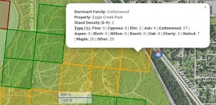
Haida Gwaii Mushroom Forager
GeoPOI LLC

The forests and woodlands of the Pacific Northwest and British Columbia, Canada are ecosystems rich with edible wild mushrooms if you know where to look. Trouble is, seasoned wild edible collectors s…

$0.49
0.0
0+ downloads
|
Maps & Navigation
0.0
$0.49
GeoPOI LLC
0+ downloads
TRANSPORTATION
0+ downloads
TRANSPORTATION
Haida Gwaii Mushroom Forager
The forests and woodlands of the Pacific Northwest and British Columbia, Canada are ecosystems rich with edible wild mu…
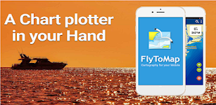
Lake Walen GPS Map Navigator
FLYTOMAP INC

Flytomap is a valid and interesting alternative,
Worldwide Marine and Outdoor Maps available when connected, thanks to viewer.flytomap.com
Worldwide Satellite images overlay on charts
Worldwide Ter…

$3.99
0.0
10+ downloads
|
Maps & Navigation
0.0
$3.99
FLYTOMAP INC
10+ downloads
TRANSPORTATION
10+ downloads
TRANSPORTATION
Lake Walen GPS Map Navigator
Flytomap is a valid and interesting alternative,
Worldwide Marine and Outdoor Maps available when connected, thanks to…
Vancouver Is. Mushroom Forager
GeoPOI LLC

The forests and woodlands of the Pacific Northwest and British Columbia, Canada are ecosystems rich with edible wild mushrooms if you know where to look. Trouble is, seasoned wild edible collectors s…


$1.49
0.0
10+ downloads
|
Maps & Navigation
0.0
$1.49
GeoPOI LLC
10+ downloads
TRANSPORTATION
10+ downloads
TRANSPORTATION
Vancouver Is. Mushroom Forager
The forests and woodlands of the Pacific Northwest and British Columbia, Canada are ecosystems rich with edible wild mu…
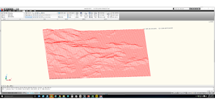
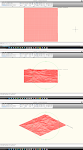
Terrain To DXF
우승호

Convert the terrain within N: -83 ~ 83 degree range as DXF files.
The max resolution : 30m × 30m , Elevation : within 7~14m error
CAD files can be used in a variety modeling and analysis.
Rece…

$3.99
0.0
10+ downloads
|
Maps & Navigation
0.0
$3.99
우승호
10+ downloads
TRANSPORTATION
10+ downloads
TRANSPORTATION
Terrain To DXF
Convert the terrain within N: -83 ~ 83 degree range as DXF files.
The max resolution : 30m × 30m , Elevation : wi…
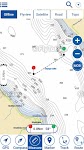
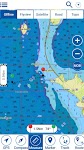
Sempach Hallwil Baldegg Charts
MAPITECH LTD

MapiTech launches on the market the best official up-to-date RNC (raster) combined with S57 nautical charts (digital): marinas, wrecks, fishing spots, boat ramps, POI.
This app displays seamlessly …


$4.99
0.0
10+ downloads
|
Maps & Navigation
0.0
$4.99
MAPITECH LTD
10+ downloads
TRANSPORTATION
10+ downloads
TRANSPORTATION
Sempach Hallwil Baldegg Charts
MapiTech launches on the market the best official up-to-date RNC (raster) combined with S57 nautical charts (digital):…
Lake Ontario GPS Map Navigator
FLYTOMAP INC

Flytomap is a valid and interesting alternative,
Worldwide Marine and Outdoor Maps available when connected, thanks to viewer.flytomap.com
Worldwide Satellite images overlay on charts
Worldwide Ter…


$3.99
0.0
10+ downloads
|
Maps & Navigation
0.0
$3.99
FLYTOMAP INC
10+ downloads
TRANSPORTATION
10+ downloads
TRANSPORTATION
Lake Ontario GPS Map Navigator
Flytomap is a valid and interesting alternative,
Worldwide Marine and Outdoor Maps available when connected, thanks to…
ViaBus +
SFR71

En ViaBus Facilitamos el trabajo a los profesionales de pasajeros por carretera. Además encuentras todo lo que en nuestro trabajo podemos necesitar. Buscar un Guía oficial de cualquier …


$16.99
0.0
100+ downloads
|
Maps & Navigation
0.0
$16.99
SFR71
100+ downloads
TRANSPORTATION
100+ downloads
TRANSPORTATION
ViaBus +
En ViaBus Facilitamos el trabajo a los profesionales de pasajeros por carretera. Además encuentras todo lo que e…
Cantabria GPS Map Navigator
FLYTOMAP INC

Flytomap is a valid and interesting alternative,
Featured on the Deck
Featured on Geomedia
Worldwide Marine and Outdoor Maps available when connected, thanks to viewer.flytomap.com
Worldwide Satellit…


$3.99
0.0
10+ downloads
|
Maps & Navigation
0.0
$3.99
FLYTOMAP INC
10+ downloads
TRANSPORTATION
10+ downloads
TRANSPORTATION
Cantabria GPS Map Navigator
Flytomap is a valid and interesting alternative,
Featured on the Deck
Featured on Geomedia
Worldwide Marine and Outdoor…
Cancun GPS Map Navigator
FLYTOMAP INC

Flytomap is a valid and interesting alternative,
Featured on the Deck
Featured on Geomedia
Worldwide Marine and Outdoor Maps available when connected, thanks to viewer.flytomap.com
Worldwide Satellit…


$3.99
0.0
5+ downloads
|
Maps & Navigation
0.0
$3.99
FLYTOMAP INC
5+ downloads
TRANSPORTATION
5+ downloads
TRANSPORTATION
Cancun GPS Map Navigator
Flytomap is a valid and interesting alternative,
Featured on the Deck
Featured on Geomedia
Worldwide Marine and Outdoor…
Altimeter Pro - Elevation
dataWorks

This app has developed with love in Switzerland. No data is collected or shared. Support us with the price of a coffee! Thank you!!
Main features:
• Display of altitude (above sea level), accur…


$1.99
0.0
5+ downloads
|
Maps & Navigation
0.0
$1.99
dataWorks
5+ downloads
TRANSPORTATION
5+ downloads
TRANSPORTATION
Altimeter Pro - Elevation
This app has developed with love in Switzerland. No data is collected or shared. Support us with the price of a coffee!…
Lake Chiemsee GPS Navigator
FLYTOMAP INC

Flytomap is a valid and interesting alternative,
Featured on the Deck
Featured on Geomedia
Worldwide Marine and Outdoor Maps available when connected, thanks to viewer.flytomap.com
Worldwide Satelli…


$3.99
0.0
10+ downloads
|
Maps & Navigation
0.0
$3.99
FLYTOMAP INC
10+ downloads
TRANSPORTATION
10+ downloads
TRANSPORTATION
Lake Chiemsee GPS Navigator
Flytomap is a valid and interesting alternative,
Featured on the Deck
Featured on Geomedia
Worldwide Marine and Outdoo…
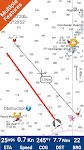
Mojo TSD Navigator
RallyOn

Mojo TSD Navigator allows a time-speed-distance rally navigator (co-driver) to report to the driver whether to speed up or slow down in order to arrive at the next rally checkpoint exactly on time an…


$19.99
0.0
10+ downloads
|
Maps & Navigation
0.0
$19.99
RallyOn
10+ downloads
TRANSPORTATION
10+ downloads
TRANSPORTATION
Mojo TSD Navigator
Mojo TSD Navigator allows a time-speed-distance rally navigator (co-driver) to report to the driver whether to speed up…
Cayuga Seneca Lakes GPS Charts
MAPITECH LTD

MapiTech launches on the market the best official up-to-date NOAA RNC (raster) combined with S57 nautical charts (digital): marinas, wrecks, fishing spots, boat ramps, POI.
This app displays seamles…


$4.99
0.0
0+ downloads
|
Maps & Navigation
0.0
$4.99
MAPITECH LTD
0+ downloads
TRANSPORTATION
0+ downloads
TRANSPORTATION
Cayuga Seneca Lakes GPS Charts
MapiTech launches on the market the best official up-to-date NOAA RNC (raster) combined with S57 nautical charts (digit…
Almicantarat
Pierre-Louis Deschamps

Enjoy shooting stars, planets and the Sun with an easy-to-use, professional and accurate celestial navigation app.
Features a smooth 3D Sky Map.
Check the celestial fix on the device native map.
Use …


$4.99
0.0
50+ downloads
|
Maps & Navigation
0.0
$4.99
Pierre-Louis Deschamps
50+ downloads
TRANSPORTATION
50+ downloads
TRANSPORTATION
Almicantarat
Enjoy shooting stars, planets and the Sun with an easy-to-use, professional and accurate celestial navigation app.
Feat…
Champlain lake Offline Charts
MAPITECH LTD

MapiTech launches on the market the best official up-to-date NOAA RNC (raster) combined with S57 nautical charts (digital): marinas, wrecks, fishing spots, boat ramps, POI.
This app displays seamles…


$4.99
0.0
50+ downloads
|
Maps & Navigation
0.0
$4.99
MAPITECH LTD
50+ downloads
TRANSPORTATION
50+ downloads
TRANSPORTATION
Champlain lake Offline Charts
MapiTech launches on the market the best official up-to-date NOAA RNC (raster) combined with S57 nautical charts (digit…
Lake Norman GPS Offline Charts
FLYTOMAP INC

Flytomap is a valid and interesting alternative
Featured on the Deck
Featured on Geomedia
Lake Norman coverage resident in the app. It works WITHOUT mobile coverage!
Worldwide Marine and Outdoor M…


$3.99
0.0
100+ downloads
|
Maps & Navigation
0.0
$3.99
FLYTOMAP INC
100+ downloads
TRANSPORTATION
100+ downloads
TRANSPORTATION
Lake Norman GPS Offline Charts
Flytomap is a valid and interesting alternative
Featured on the Deck
Featured on Geomedia
Lake Norman coverage residen…
US East Gps Map Navigator
FLYTOMAP INC

Flytomap is a valid and interesting alternative,
Worldwide Marine and Outdoor Maps available when connected, thanks to viewer.flytomap.com
Worldwide Satellite images overlay on charts
Worldwide Terr…


$4.99
0.0
10+ downloads
|
Maps & Navigation
0.0
$4.99
FLYTOMAP INC
10+ downloads
TRANSPORTATION
10+ downloads
TRANSPORTATION
US East Gps Map Navigator
Flytomap is a valid and interesting alternative,
Worldwide Marine and Outdoor Maps available when connected, thanks to …
Florida Everglades GPS Charts
FLYTOMAP INC

Flytomap is a valid and interesting alternative,
Featured on the Deck
Featured on Geomedia
Worldwide Marine and Outdoor Maps available when connected, thanks to viewer.flytomap.com
Worldwide Satellit…


$3.99
0.0
0+ downloads
|
Maps & Navigation
0.0
$3.99
FLYTOMAP INC
0+ downloads
TRANSPORTATION
0+ downloads
TRANSPORTATION
Florida Everglades GPS Charts
Flytomap is a valid and interesting alternative,
Featured on the Deck
Featured on Geomedia
Worldwide Marine and Outdoor…
Spain Mediterranean GPS Charts
FLYTOMAP INC

Flytomap is a valid and interesting alternative,
Featured on the Deck
Featured on Geomedia
Worldwide Marine and Outdoor Maps available when connected, thanks to viewer.flytomap.com
Worldwide Satellit…


$4.99
0.0
50+ downloads
|
Maps & Navigation
0.0
$4.99
FLYTOMAP INC
50+ downloads
TRANSPORTATION
50+ downloads
TRANSPORTATION
Spain Mediterranean GPS Charts
Flytomap is a valid and interesting alternative,
Featured on the Deck
Featured on Geomedia
Worldwide Marine and Outdoor…
Potomac River Was GPS Charts
FLYTOMAP INC

Flytomap is a valid and interesting alternative,
Worldwide Marine and Outdoor Maps available when connected, thanks to viewer.flytomap.com
Worldwide Satellite images overlay on charts
Worldwide Ter…


$2.99
0.0
10+ downloads
|
Maps & Navigation
0.0
$2.99
FLYTOMAP INC
10+ downloads
TRANSPORTATION
10+ downloads
TRANSPORTATION
Potomac River Was GPS Charts
Flytomap is a valid and interesting alternative,
Worldwide Marine and Outdoor Maps available when connected, thanks to…
Android Statistics
© 2010-2024 - AppBrain