AppBrain
|
Apps
Apps
Apps being viewed right now
Trending apps today
Most popular apps
All-time most downloaded apps
Top rated apps
Statistics
Docs
Developers
Sign up
Log in
Android Apps
>
Maps & Navigation
>
Paid
Category
Maps & Navigation
Sort by
Trending
Recent downloads
All-time downloads
Top rated
Popular in
Filter by
Off
Free
Paid
New
Updated
Price Reduced
No ads
Page 4 of the
trending Paid Maps & Navigation Apps for Android right now
iLogbook Unlocker
Zeroed
This application will unlock the full version of iLogbook. The full version includes: -Access to new features before free users -Faster support -Warm fuzzy feeling for helping out a solo developer …
$1.85
0.0
10+ downloads
|
Maps & Navigation
0.0
$1.85
Zeroed
10+ downloads
TRANSPORTATION
iLogbook Unlocker
This application will unlock the full version of iLogbook. The full version includes: -Access to new features before f…
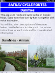
Satnav Cycle Routes - Dumfries – Click to show
Satnav Cycle Routes - Dumfries
Ian Lochhead
Dumfries - Annan. 43 miles Dumfries - Lochmabon. 40 miles Dumfries - New Abbey. 27 miles 3 Satnav Cycle Routes around Dumfries using cycle paths and roads on Google Maps. Every route has turn-by-tur…
$0.99
0.0
0+ downloads
|
Maps & Navigation
0.0
$0.99
Ian Lochhead
0+ downloads
TRANSPORTATION
Satnav Cycle Routes - Dumfries
Dumfries - Annan. 43 miles Dumfries - Lochmabon. 40 miles Dumfries - New Abbey. 27 miles 3 Satnav Cycle Routes around …
Greece West GPS Map Navigator – Click to show
Greece West GPS Map Navigator
FLYTOMAP INC
Flytomap is a valid and interesting alternative, Featured on the Deck Featured on Geomedia Worldwide Marine and Outdoor Maps available when connected, thanks to viewer.flytomap.com Worldwide Satellit…
$3.99
0.0
10+ downloads
|
Maps & Navigation
0.0
$3.99
FLYTOMAP INC
10+ downloads
TRANSPORTATION
Greece West GPS Map Navigator
Flytomap is a valid and interesting alternative, Featured on the Deck Featured on Geomedia Worldwide Marine and Outdoor…
Black Sea GPS Nautical Charts – Click to show
Black Sea GPS Nautical Charts
FLYTOMAP INC
Flytomap is a valid and interesting alternative. Featured on the Deck Featured on Geomedia Worldwide Marine and Outdoor Maps available when connected, thanks to viewer.flytomap.com Worldwide Satellit…
$3.99
0.0
10+ downloads
|
Maps & Navigation
0.0
$3.99
FLYTOMAP INC
10+ downloads
TRANSPORTATION
Black Sea GPS Nautical Charts
Flytomap is a valid and interesting alternative. Featured on the Deck Featured on Geomedia Worldwide Marine and Outdoor…
Lower Gar Lake - IOWA GPS Map – Click to show
Lower Gar Lake - IOWA GPS Map
FLYTOMAP INC
Flytomap is a valid and interesting alternative, Benetti Yachts Featured on the Deck Featured on Geomedia Worldwide Marine and Outdoor Maps available when connected, thanks to viewer.flytomap.com Wor…
$1.99
0.0
0+ downloads
|
Maps & Navigation
0.0
$1.99
FLYTOMAP INC
0+ downloads
TRANSPORTATION
Lower Gar Lake - IOWA GPS Map
Flytomap is a valid and interesting alternative, Benetti Yachts Featured on the Deck Featured on Geomedia Worldwide Mar…
Globe - Earth 3D world map
Cyrille Mouret
Globe on Wear OS will allow you to always have with you a 3D representation of the Earth like the one you can find in stores. It is handled in the same way by swiping its finger on the watch screen …
$2.49
0.0
50+ downloads
|
Maps & Navigation
0.0
$2.49
Cyrille Mouret
50+ downloads
TRANSPORTATION
Globe - Earth 3D world map
Globe on Wear OS will allow you to always have with you a 3D representation of the Earth like the one you can find in s…
Recce - Planning & Orienting
Nujiak
A handheld GPS and calculator in one app. Built with the Maps SDK and Fused Location API for high accuracy and low power consumption, suitable for long expeditions. Features: 🗺 Map • Instant…
$0.99
4.0
10,000+ downloads
|
Maps & Navigation
4.0
$0.99
Nujiak
10,000+ downloads
TRANSPORTATION
Recce - Planning & Orienting
A handheld GPS and calculator in one app. Built with the Maps SDK and Fused Location API for high accuracy and low powe…
SG BusLeh Full Unlock
OriginallyUS.SG - Award Winning App Consultancy
NOTE 1: BusLeh Unlock does not currently remove BusLeh announcements, which may contain important announcements such as traffic breakdown, data service breakdown, as well as text-based deals and offe…
$74.99
0.0
1,000+ downloads
|
Maps & Navigation
0.0
$74.99
OriginallyUS.SG - Award Winning App Consultancy
1,000+ downloads
TRANSPORTATION
SG BusLeh Full Unlock
NOTE 1: BusLeh Unlock does not currently remove BusLeh announcements, which may contain important announcements such as…
Valencia Almerimar Offline Map – Click to show
Valencia Almerimar Offline Map
MAPITECH LTD
MapiTech launches on the market the best official up-to-date RNC (raster) combined with S57 nautical charts (digital): marinas, wrecks, fishing spots, boat ramps, POI. This app displays seamlessly …
$4.99
0.0
0+ downloads
|
Maps & Navigation
0.0
$4.99
MAPITECH LTD
0+ downloads
TRANSPORTATION
Valencia Almerimar Offline Map
MapiTech launches on the market the best official up-to-date RNC (raster) combined with S57 nautical charts (digital):…
Cyclades GPS Map Navigator – Click to show
Cyclades GPS Map Navigator
FLYTOMAP INC
Flytomap is a valid and interesting alternative, Featured on the Deck Featured on Geomedia Worldwide Marine and Outdoor Maps available when connected, thanks to viewer.flytomap.com Worldwide Satellit…
$3.99
0.0
10+ downloads
|
Maps & Navigation
0.0
$3.99
FLYTOMAP INC
10+ downloads
TRANSPORTATION
Cyclades GPS Map Navigator
Flytomap is a valid and interesting alternative, Featured on the Deck Featured on Geomedia Worldwide Marine and Outdoor…
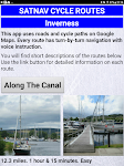
Satnav Cycle Routes –Inverness – Click to show
Satnav Cycle Routes –Inverness
Ian Lochhead
Satnav Cycle Routes around Inverness using cycle paths and quiet roads. Every route has turn-by-turn navigation with voice instruction. Enjoy the benefits of cycling a whole route by following Sat Na…
$0.99
0.0
0+ downloads
|
Maps & Navigation
0.0
$0.99
Ian Lochhead
0+ downloads
TRANSPORTATION
Satnav Cycle Routes –Inverness
Satnav Cycle Routes around Inverness using cycle paths and quiet roads. Every route has turn-by-turn navigation with vo…
Golfe Du Lion Offline Charts – Click to show
Golfe Du Lion Offline Charts
MAPITECH LTD
MapiTech launches on the market the best official up-to-date RNC (raster) combined with S57 nautical charts (digital): marinas, wrecks, fishing spots, boat ramps, POI. This app displays seamlessly …
$4.99
0.0
0+ downloads
|
Maps & Navigation
0.0
$4.99
MAPITECH LTD
0+ downloads
TRANSPORTATION
Golfe Du Lion Offline Charts
MapiTech launches on the market the best official up-to-date RNC (raster) combined with S57 nautical charts (digital):…
WHERE TO FLY
Itis S.L
"Where to Fly es tu asistente para volar drones en España, ayudándote a encontrar las zonas permitidas y cumplir con las regulaciones vigentes. Con información actualizada y…
$11.99
0.0
10+ downloads
|
Maps & Navigation
0.0
$11.99
Itis S.L
10+ downloads
TRANSPORTATION
WHERE TO FLY
"Where to Fly es tu asistente para volar drones en España, ayudándote a encontrar las zonas permitid…
Next Bus Dublin Pro
Stephen McBride
Next Bus Dublin uses the Dublin Bus realtime information system to tell you exactly when your bus is arriving. No more guessing using fictional timetables! The app is packed with useful features, loo…
$2.49
0.0
1,000+ downloads
|
Maps & Navigation
0.0
$2.49
Stephen McBride
1,000+ downloads
TRANSPORTATION
Next Bus Dublin Pro
Next Bus Dublin uses the Dublin Bus realtime information system to tell you exactly when your bus is arriving. No more …
Sam Rayburn Offline GPS Charts – Click to show
Sam Rayburn Offline GPS Charts
FLYTOMAP INC
Flytomap is a valid and interesting alternative Worldwide Marine and Outdoor Maps available when connected, thanks to viewer.flytomap.com Worldwide Satellite images overlay on charts Worldwide Terra…
$3.99
0.0
50+ downloads
|
Maps & Navigation
0.0
$3.99
FLYTOMAP INC
50+ downloads
TRANSPORTATION
Sam Rayburn Offline GPS Charts
Flytomap is a valid and interesting alternative Worldwide Marine and Outdoor Maps available when connected, thanks to v…
Israel Offline Nautical Charts – Click to show
Israel Offline Nautical Charts
MAPITECH LTD
MapiTech launches on the market the best official up-to-date RNC (raster) combined with S57 nautical charts (digital): marinas, wrecks, fishing spots, boat ramps, POI. This app displays seamlessly …
$4.99
0.0
0+ downloads
|
Maps & Navigation
0.0
$4.99
MAPITECH LTD
0+ downloads
TRANSPORTATION
Israel Offline Nautical Charts
MapiTech launches on the market the best official up-to-date RNC (raster) combined with S57 nautical charts (digital):…
Sammamish Lake WA GPS Charts – Click to show
Sammamish Lake WA GPS Charts
FLYTOMAP INC
Flytomap is a valid and interesting alternative, Worldwide Marine and Outdoor Maps available when connected, thanks to viewer.flytomap.com Worldwide Satellite images overlay on charts Worldwide Terr…
$2.99
0.0
1+ downloads
|
Maps & Navigation
0.0
$2.99
FLYTOMAP INC
1+ downloads
TRANSPORTATION
Sammamish Lake WA GPS Charts
Flytomap is a valid and interesting alternative, Worldwide Marine and Outdoor Maps available when connected, thanks to …
Portugal GPS Map Navigator – Click to show
Portugal GPS Map Navigator
FLYTOMAP INC
Flytomap is a valid and interesting alternative, Featured on the Deck Featured on Geomedia Worldwide Marine and Outdoor Maps available when connected, thanks to viewer.flytomap.com Worldwide Satelli…
$3.99
0.0
10+ downloads
|
Maps & Navigation
0.0
$3.99
FLYTOMAP INC
10+ downloads
TRANSPORTATION
Portugal GPS Map Navigator
Flytomap is a valid and interesting alternative, Featured on the Deck Featured on Geomedia Worldwide Marine and Outdoo…
East England GPS Map Navigator – Click to show
East England GPS Map Navigator
FLYTOMAP INC
Flytomap is a valid and interesting alternative, Featured on the Deck Featured on Geomedia Worldwide Marine and Outdoor Maps available when connected, thanks to viewer.flytomap.com Worldwide Satellit…
$5.99
0.0
0+ downloads
|
Maps & Navigation
0.0
$5.99
FLYTOMAP INC
0+ downloads
TRANSPORTATION
East England GPS Map Navigator
Flytomap is a valid and interesting alternative, Featured on the Deck Featured on Geomedia Worldwide Marine and Outdoor…
MTDash Pro for C-U MTD
Ben Nordick
All the features of MTDash with extra cool stuff: * No ads! * "Go Adventuring" mode that tracks which stops you've been to - can you visit all 1000+? * Double/long buses identified as such…
$0.99
0.0
1+ downloads
|
Maps & Navigation
0.0
$0.99
Ben Nordick
1+ downloads
TRANSPORTATION
MTDash Pro for C-U MTD
All the features of MTDash with extra cool stuff: * No ads! * "Go Adventuring" mode that tracks which stops …
United States
United Kingdom
Germany
Norway
Sweden
Australia
Netherlands
Italy
Denmark
Hong Kong
Brazil
France
Canada
Spain
Portugal
South Korea
Japan
Poland
Hungary
India
Finland
Thailand
Russia
General
Overall
Applications
Games
Join AppBrain
Join AppBrain to get app recommendations
Apps
Art & Design
Auto & Vehicles
Beauty
Books & Reference
Business
Comics
Communication
Dating
Education
Entertainment
Events
Finance
Food & Drink
Health & Fitness
House & Home
Libraries & Demo
Lifestyle
Maps & Navigation
Medical
Music & Audio
News & Magazines
Parenting
Personalization
Photography
Productivity
Shopping
Social
Sports
Tools
Travel & Local
Video Players & Editors
Weather
Games
Action
Adventure
Arcade
Board
Card
Casino
Casual
Educational
Music
Puzzle
Racing
Role Playing
Simulation
Sports Games
Strategy
Trivia
Word