

ArrowToWaypoint is made and published by 4neuro.com. AppBrain is an independent app data site and isn't affiliated with 4neuro.com. The app name, icon, screenshots and description belong to 4neuro.com and are shown as published on the App Store.
AppBrain's verdict
- Rating on App Store
- 4.00
- 1 ratings
- Last updated
- November 26, 2025
It doesn't have enough ratings yet to judge what users think.
Rankings
App Store top chartsApp Store Rankings for ArrowToWaypoint
Competitors
Similar apps and more from 4neuro.comMore from 4neuro.com

Releases
Updates seen on the App Store- Version
- 2.0
- Launched
- June 2025
No changelog data
User feedback
Ratings and reviews on the App StoreComments on ArrowToWaypoint for iOS
We don't have enough comments to show example comments. Please check back later.
Technology
Found in the app by AppBrain- Price
- Free
- App size
- 723.0 KB
- Content rating
- Everyone
Technologies used by ArrowToWaypoint
About the app and developer
About ArrowToWaypoint
ArrowToWaypoint is a navigation app developed by 4neuro.com.
What is the rating of ArrowToWaypoint?
ArrowToWaypoint is rated 4.00 out of 5 stars, based on one rating ratings.
Is ArrowToWaypoint free?
ArrowToWaypoint is free. The app size is 723.00 kB. The latest version available is 2.0. The last update was on November 26, 2025.
What are the requirements for ArrowToWaypoint?
The app has a content rating of Everyone. The app has been available on the App Store since June 2025.
Developer information for 4neuro.com
Address:
Store listing
By 4neuro.com, from the App Store

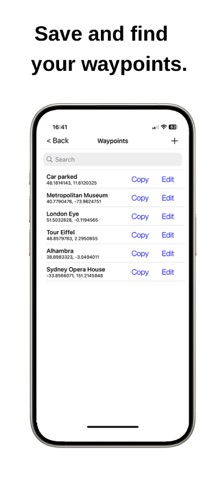
Description by 4neuro.com Written by the developer, not by AppBrain. Click to read.
Whether you're standing in the forest, hiking off-trail, or driving through the desert.
Or just want to find your parked car.
* Works without internet, even when map apps fail.
* Shows you the direction and distance to a target point.
* Save your current location with a single tap and navigate back to it.
* Find a target point on the integrated map.
* Readable even in bright sunlight – optimized for outdoor use.
* Save, edit, search, and manage any number of waypoints.
* Save / open / export your waypoint collection (CSV or GPX)
* Originally developed for personal use.
* Continuously used, improved, and expanded by the developer.