

Ascent EFB is made and published by GeoSpatios. AppBrain is an independent app data site and isn't affiliated with GeoSpatios. The app name, icon, screenshots and description belong to GeoSpatios and are shown as published on the App Store.
AppBrain's verdict
New- Rating on App Store
- 5.00
- 7 ratings
- Last updated
- October 8, 2026
Ascent EFB came out 87 days ago. It doesn't have enough ratings yet to judge what users think.
Rankings
App Store top chartsApp Store Rankings for Ascent EFB
Competitors
Similar apps and more from GeoSpatiosAlternatives to Ascent EFB


Releases
Updates seen on the App Store- Version
- 1.7
- Launched
- July 2026
No changelog data
User feedback
Ratings and reviews on the App StoreComments on Ascent EFB for iOS
We don't have enough comments to show example comments. Please check back later.
Technology
Found in the app by AppBrain- Price
- Free
- App size
- 120.6 MB
- Content rating
- Medium
Technologies used by Ascent EFB
About the app and developer
About Ascent EFB
Ascent EFB is a navigation app developed by GeoSpatios.
User Ratings
Ascent EFB is rated 5.00 out of 5 stars. The rating is based on 7 ratings.
App Information
Ascent EFB is freely available from the App Store. The app size is 120.65 MB. The latest version available is 1.7. The last update was on October 8, 2026.
Technical Requirements
The app has a content rating of Medium Maturity. The app has been available on the App Store since July 2026.
Developer information for GeoSpatios
Address:
Store listing
By GeoSpatios, from the App Store




Description by GeoSpatios Written by the developer, not by AppBrain. Click to read.
Whether you're a student pilot flying your first cross-country or a working crew planning a long leg, Ascent gives you a clean, high-performance moving map and the tools to back it up. No clutter, no learning curve, just the picture you need to fly.
FLIGHT PLANNING
Build your route right on the map. Set your departure and destination, drop waypoints along the way, and watch the whole flight come together from takeoff to touchdown. Ascent runs the numbers for you: distance, ETE, and fuel burn, laid out in a clean nav log so you know exactly what each leg costs before you fly it. Your plan stays live as conditions change, so you always know where you're headed and what's between you and the airport.
WEATHER
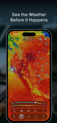
Get the full picture before you go and stay ahead of it en route. Ascent layers a deep set of weather products right over your route, so you can see the sky the way it actually is:
Radar and precipitation, thunderstorms, convective clouds, hail severity, and tropical cyclones for the big-picture threats. Winds aloft with wind speed and wind speed contours, plus temperature, dew point, and humidity to understand what the air is doing. Cloud cover and visibility for the go/no-go call, and sea-level pressure to read the systems moving through. PIREPs, AIRMETs and SIGMETs, Center Weather Advisories (CWA), and the Traffic Flow Management Convective Forecast (TCF). Flying overwater or oceanic? Ocean currents and wave height layers have you covered.
Turn on only what you want and keep the map clean.
GLOBAL AIRSPACE
Fly anywhere. Ascent shows airspace worldwide, so the map works the same whether you're shooting the pattern at your home field or crossing into a new country. See Class B, C, D, and E, MOAs, restricted and prohibited areas, and TFRs, so you know what's around you and what's ahead before you get there.
3D
It’s time to stop thinking of EFBs in a 2D manner. We’ve decided that rather than the traditional map layout, the modern pilot should be able to interact with their navigational data with new perspective. You can now enhance your situational awareness and ease of use of your EFB by interacting with a 3D map.
LOGBOOK
Keep your hours where you fly them. Log your flights in the app so your times, currency, and history are always with you, right next to the map you flew them on.
CHARTS
Geo-referenced FAA charts, tied to your position on the map. VFR Sectionals and Terminal Area Charts, plus IFR Enroute Low, High and Area charts. Download them before you go and they keep working with no signal at all.
OFFLINE
Charts and the full 3D map work completely offline. Download the regions you need while you have signal, and the whole picture stays with you when the bars do not.
COMING SOON
We're just getting started. On the way:
Mayday Mode. One tap stands up 7700 and guard 121.5, ready for you to confirm. You fly the airplane.
Ascent EFB is built by pilots, for pilots. We ship fast and we listen. Tell us what you want to see next.
Terms of Use (EULA): https://www.apple.com/legal/internet-services/itunes/dev/stdeula/