

AxisTrack LandXML Survey
AxisTrack LandXML Survey is made and published by Ertan Selcuk Atalay. AppBrain is an independent app data site and isn't affiliated with Ertan Selcuk Atalay. The app name, icon, screenshots and description belong to Ertan Selcuk Atalay and are shown as published on the App Store.
AppBrain's verdict
- Last updated
- June 3, 2026
- Size
- 57.5 MB
User feedback
Ratings and reviews on the App StoreComments on AxisTrack LandXML Survey for iOS
We don't have enough comments to show example comments. Please check back later.
Store listing
By Ertan Selcuk Atalay, from the App Store


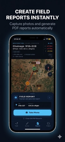
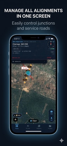
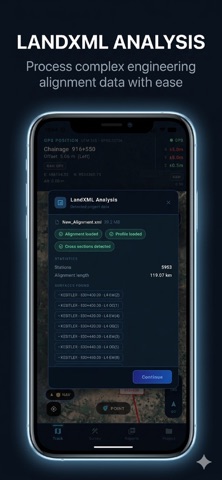
Description by Ertan Selcuk Atalay Written by the developer, not by AppBrain. Click to read.
Designed for real field operations, AxisTrack helps engineering teams work directly with alignments, chainage/offset navigation, cross-sections and coordinate systems on-site.
Unlike generic GPS or GIS apps, AxisTrack focuses on infrastructure engineering workflows.
LANDXML WORKFLOWS
• Import and analyze LandXML projects
• Support for alignment-based field operations
• Horizontal and vertical geometry support
• Multi-alignment project management
• Fast mobile project access in the field
FIELD ENGINEERING TOOLS
• Real-time chainage and offset positioning
• Alignment navigation and station control
• Cross-section visualization
• Cut/fill and as-built verification workflows
• PDF field reporting with photos
GLOBAL CRS SUPPORT
AxisTrack includes:
• 197 countries
• 4893 coordinate systems
• UTM systems
• National grids
• Local coordinate system workflows
Coordinate workflows are designed for international railway, highway and infrastructure projects.
FIELD OPERATIONS
• KML/KMZ project overlays
• Offline field workflows
• External GNSS support
• NTRIP compatibility
• Background positioning support
BUILT FOR PROFESSIONALS
Used in:
• Railway projects
• Highway construction
• Infrastructure field operations
• Earthwork and grading workflows
• Alignment control operations
IMPORTANT
Positioning accuracy may vary depending on hardware, environment and correction infrastructure.
Critical engineering measurements should always be verified using approved survey equipment and professional survey methods.
Privacy Policy:
https://esanetsoft.com/privacy
Safety and technology
Found in the app by AppBrain- Price
- Free
- App size
- 57.5 MB
- Content rating
- Everyone
Technologies used by AxisTrack LandXML Survey
Releases
Updates seen on the App Store- Version
- 1.2.1
- Launched
- April 2026
No changelog data
Rankings
App Store top chartsApp Store Rankings for AxisTrack LandXML Survey
About the app and developer
About AxisTrack LandXML Survey
AxisTrack LandXML Survey is a navigation app developed by Ertan Selcuk Atalay.
User Ratings
The app has no ratings yet.
App Information
AxisTrack LandXML Survey is freely available from the App Store. The app size is 57.48 MB. The latest version available is 1.2.1. The last update was on June 3, 2026.
Technical Requirements
The app has a content rating of Everyone. The app has been available on the App Store since April 2026.
Developer information for Ertan Selcuk Atalay
Address:
Frequently asked questions about AxisTrack LandXML Survey
Is AxisTrack LandXML Survey free?
Yes. AxisTrack LandXML Survey is free on the App Store.
Is AxisTrack LandXML Survey still available?
Yes. AxisTrack LandXML Survey is on the App Store, and the last update we saw was on June 3, 2026.
How large is AxisTrack LandXML Survey?
AxisTrack LandXML Survey is 57.48 MB.
Is AxisTrack LandXML Survey suitable for children?
App Store rates the content of AxisTrack LandXML Survey as suitable for everyone.
Who made AxisTrack LandXML Survey?
AxisTrack LandXML Survey was developed by Ertan Selcuk Atalay. It is listed in the navigation category on the App Store.