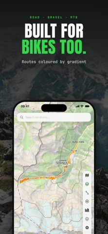
BRouter - Offline Nav is made and published by
Ivan Blajic.
AppBrain is an independent app data site and isn't affiliated with Ivan Blajic.
The app name, icon, screenshots and description belong to Ivan Blajic and are shown as
published on the App Store.
About BRouter - Offline Nav
BRouter - Offline Nav is a navigation app developed by Ivan Blajic.
User Ratings
The app has no ratings yet.
App Information
BRouter - Offline Nav is freely available from the App Store. The app size is 32.29 MB. The latest version available is 4.0. The last update was on October 12, 2026.
Technical Requirements
The app has a content rating of Everyone. The app has been available on the App Store since March 2026.
Description by Ivan Blajic(from the App Store)
BRouter is a powerful offline mapping and navigation app for driving, walking, hiking, cycling and more. Plan routes, explore detailed topographic maps, record tracks and navigate without an internet connection. Choose from built-in routing profiles or create and use your own custom BRouter profiles.
OFFLINE MAPS & ROUTING Download maps and elevation data for offline use. Plan routes along roads, paths and trails, with directions tailored to your chosen activity and routing profile.
TOPOGRAPHIC MAPS Explore four map types, including detailed vector topographic maps with on-device contour lines and hillshading. Customize contour intervals in meters or feet and overlay hiking, cycling, running routes and ski pistes.
TRACK RECORDING & BACKTRACK Record journeys with live distance, time, speed and elevation gain. Pause and resume recordings, follow tracks back with Backtrack, and explore interactive elevation profiles.
YOUR MAPS, YOUR WAY Import and export GPX tracks, search for places and addresses, and manage your saved routes. Download offline areas before heading out and explore even without mobile coverage.
PRIVACY No account or sign-in required. Your recorded tracks stay on your device and are never uploaded.
PRO FEATURES Recording, Backtrack, all map styles and contour lines are always free. A one-time Pro purchase unlocks unlimited offline areas, routes of any length, and GPX import and export.
IMPORTANT Maps, elevation data and routes may be inaccurate or incomplete. Always carry appropriate navigation equipment, check local conditions and use your own judgment. Never rely on the app alone for navigation or safety.
Not affiliated with or endorsed by the U.S. Geological Survey or the U.S. government.
Each subscription will automatically renew 3 days before the expiration date for
the same time period. Subscriptions can be cancelled at any time before the renewal.