

Campound is made and published by Michael White. AppBrain is an independent app data site and isn't affiliated with Michael White. The app name, icon, screenshots and description belong to Michael White and are shown as published on the App Store.
AppBrain's verdict
- Last updated
- September 5, 2026
- Size
- 27.9 MB
User feedback
Ratings and reviews on the App StoreComments on Campound for iOS
We don't have enough comments to show example comments. Please check back later.
Store listing
By Michael White, from the App Store




Description by Michael White Written by the developer, not by AppBrain. Click to read.
Campound maps national parks, national forests, BLM land, and wilderness — along
with the trails, forest roads, and OHV routes that run through them — and helps
you find a place to camp. Built to keep working offline, because the best
camping is exactly where the cell bars disappear.
Plan it on Wi-Fi. Live it off-grid.
FIND A SPOT
Search reservable campgrounds by date range and see live Recreation.gov
availability — the nights actually open, not just a directory. Tap any site for
info, ratings, reviews, and an availability calendar.
KNOW WHOSE LAND YOU'RE ON
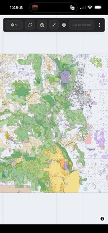
Color-coded PAD-US ownership shows national parks, forests, BLM, wilderness,
monuments, and state, local, tribal and private land at a glance, with a
toggleable legend. Essential for dispersed camping.
PLAN A TRIP
Build a trip from any mix of campgrounds, trails, forest roads, OHV and BLM
routes, and your own points and lines. Drop in a driving route and Campound
finds the campgrounds along the corridor with availability — or skip pavement
entirely and stitch an off-piste itinerary that never touches a developed site.
TRAILS & ROUTES
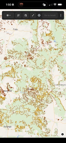
Tap National Forest trails, Forest Service roads, OHV and BLM routes, search them
in the current view, and open any route for an elevation profile with gain, loss
and distance.
NAVIGATE THERE
Turn-by-turn navigation to any campground, trailhead, or marked point — voice
prompts, ETA, live drift-recalc. The hybrid router drives the paved portion via
Mapbox, then takes over with its own A* across Forest Service, BLM, and OHV
roads that mainstream nav apps don't cover. The off-road portion runs on the
bundled tiles, so you keep going when the signal doesn't. On a trail
destination, it switches to follow-the-polyline mode with off-trail and
approaching-end cues.
MAP IT YOUR WAY
Four basemaps — Street, Topo, Satellite, and an offline coordinate Grid. Locate
yourself with one tap, jump to any place by search or coordinates, and save
campgrounds, rec areas, routes, and your own points to Favorites with optional
1–5 star ratings.
MARK YOUR OWN
Draw points, lines and polygons styled by a customizable dictionary of pin types,
capture GPS as you move, and pin geotagged photos that cluster on the map and
open in a carousel. Saves on-device; syncs when online. Export points, lines and
full-res photos as a single .campound archive and share via Mail, AirDrop or
Files. Import any .campound (Skip or Update on duplicates, IDs preserved). The
underlying GeoJSON opens in QGIS, Google Earth, or any GIS tool. Your data is
yours.
iPHONE, iPAD & APPLE WATCH
Universal app — one download, three devices. iPad gets side-by-side detail
panels for planning a route on the couch. Apple Watch captures waypoints and
tracks hands-free and mirrors the phone's live turn-by-turn with haptics 400 m
before each turn, on completion, and at arrival. A guaranteed-delivery outbox
means nothing your watch records is ever lost.
WORKS OFFLINE
Maps for all 50 states ship inside the app — no download step. The map, saved
spots, trail search, and the off-road portion of navigation all keep working
with no connection. The basemap falls back to a coordinate grid when signal
drops and restores when you're back. (Live availability, place search, and
paved-road routing need a signal — Campound tells you clearly when they do.)
FREE. NO ACCOUNT.
No subscription. No ads. No account to create. No tracking. Just open it and go.
DATA YOU CAN TRUST
Built on authoritative public datasets: Recreation.gov / RIDB for campgrounds,
availability, and reviews; USGS PAD-US for protected-area boundaries; USFS and
BLM for trails, roads, and routes; basemaps from OpenFreeMap, OpenTopoMap, and
Esri; elevation from Open-Elevation; on-road directions from Mapbox.
Campound is independent and not affiliated with or endorsed by NPS, USFS, BLM,
or Recreation.gov. Always confirm current regulations and conditions with the
managing agency before you travel.
Safety and technology
Found in the app by AppBrain- Price
- Free
- App size
- 27.9 MB
- Content rating
- Everyone
Technologies used by Campound
Releases
Updates seen on the App Store- Version
- 1.371
- Launched
- June 2026
No changelog data
Alternatives
Similar apps and more from Michael WhiteAlternatives to Campound


Rankings
App Store top chartsApp Store Rankings for Campound
About the app and developer
About Campound
Campound is a travel app developed by Michael White.
What is the rating of Campound?
Campound has no ratings yet.
Is Campound free?
Campound is free. The app size is 27.94 MB. The latest version available is 1.371. The last update was on September 5, 2026.
What are the requirements for Campound?
The app has a content rating of Everyone. The app has been available on the App Store since June 2026.
Developer information for Michael White
Address:
Frequently asked questions about Campound
Is Campound free?
Yes. Campound is free on the App Store.
Is Campound still available?
Yes. Campound is on the App Store, and the last update we saw was on September 5, 2026.
How large is Campound?
Campound is 27.94 MB.
Is Campound suitable for children?
App Store rates the content of Campound as suitable for everyone.
Who made Campound?
Campound was developed by Michael White. It is listed in the travel category on the App Store.
What are the best alternatives to Campound?
People looking at Campound also look at these travel apps: DryRig, Boondockr: Free Camping Log, CamperPlaces, CampRadar – Campsite Finder, VistaBound.