



AppBrain's verdict
- Last updated
- September 25, 2026
- Size
- 66.8 MB
User feedback
Ratings and reviews on the App StoreComments on CoordKit: MGRS UTM Map & GPS for iOS
We don't have enough comments to show example comments. Please check back later.
Store listing
By Benthotage Udayashan, from the App StoreDescription by Benthotage Udayashan Written by the developer, not by AppBrain. Click to read.
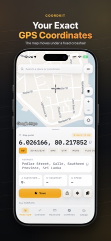
Aim the crosshair at any point on the map and CoordKit shows its GPS coordinates live — in MGRS, UTM, DMS, decimal degrees or Plus Codes. The map moves under a fixed reticle, so your thumb never covers the number you are reading.
EVERY COORDINATE FORMAT, ON ONE PANEL
• MGRS map grids and UTM zones
• DMS (degrees, minutes, seconds) and decimal degrees
• Latitude longitude with hemisphere letters, plus Plus Codes
• A coordinate converter that reads any format you paste
Paste a grid reference, a DMS string or a latitude longitude pair and the coordinate converter returns every other format at once. Switch the readout to an MGRS map grid and the crosshair keeps up as you pan — a UTM geo map reference without the handheld unit.
CoordKit works as a grid reference finder for any point you can put a crosshair on. Because the grid reference finder runs off the map rather than a search box, it works for the corner of a field that has no address.
WHAT THE PANEL TELLS YOU ABOUT A POINT
Every point carries more than its GPS coordinates. CoordKit reads the height above sea level, the horizontal accuracy of the fix, and a reverse-geocoded address for the spot the crosshair is on — so a set of latitude longitude numbers becomes somewhere you can describe to someone else.
The accuracy figure is not decoration. CoordKit truncates the coordinate to the precision the fix actually justifies, so you are never shown six decimal places of a three-metre reading.
Save any point to a searchable library with a name, its address and the format you were reading it in. Reopen it months later and the same latitude longitude pair, the same MGRS map reference and the same DMS string are all still one tap apart.
GEOTAG AND STAMP PHOTOS
The stamped camera burns coordinates, address, elevation, accuracy and time into the image and writes them to EXIF as well. Use it to geotag photo evidence for a claim, a job sheet or a site record — the position is in the pixels and in the file. It is a timestamp camera and a coordinate camera at once, so nothing needs re-photographing to add the other half.
It is the gps map camera idea done properly: a typeset panel, not a scrawled watermark. Add location to photo automatically, and every geotag photo lands in the library beside the points from the same visit. If you have used a gps map camera before, this one still reads clearly at full zoom. As a timestamp camera it writes the time beside the position, so a site record carries both without a second app.
IN THE FIELD
• Live GPS coordinates with honest accuracy — truncated to the precision the fix justifies
• Height above sea level, horizontal accuracy and a reverse-geocoded address
• Compass with a magnetic interference warning
• Speed dashboard with trip distance and moving average
• Satellite and terrain imagery, with a UTM geo map or MGRS grid over it
• A grid reference finder that works on the map, not through a search box
• Works offline apart from address and elevation lookups
SAVE AND EXPORT
Every point and photo goes to a searchable library. Export to GPX, KML or CSV for Google Earth, QGIS or a handheld GPS — and import a GPX or KML file back in to pick up someone else's points. A GPX round trip keeps the coordinate converter honest: what you exported is what comes back.
COORDKIT PRO
Free: your live position with honest accuracy, the address, search, the map, decimal degrees, DMS, Plus Codes and three saved points.
Pro unlocks every tool — UTM and MGRS, the converter, measurement, the compass, elevation, speed, the stamped camera, satellite and terrain imagery, GPX/KML/CSV export and import, guidance and unlimited points.
Terms of Use (EULA): https://dewmina.dev/legal/coordkit/terms
Safety and technology
Found in the app by AppBrain- Price
- Free
- App size
- 66.8 MB
- Content rating
- Everyone
Technologies used by CoordKit: MGRS UTM Map & GPS
Releases
Updates seen on the App Store- Version
- 1.0.1
- Launched
- September 2026
No changelog data
Alternatives
Similar apps and more from Benthotage UdayashanAlternatives to CoordKit: MGRS UTM Map & GPS


More from Benthotage Udayashan


Rankings
App Store top chartsApp Store Rankings for CoordKit: MGRS UTM Map & GPS
About the app and developer
About CoordKit: MGRS UTM Map & GPS
CoordKit: MGRS UTM Map & GPS is a navigation app developed by Benthotage Udayashan.
User Ratings
The app has no ratings yet.
App Information
CoordKit: MGRS UTM Map & GPS is freely available from the App Store. The app size is 66.82 MB. The latest version available is 1.0.1. The last update was on September 25, 2026.
Technical Requirements
The app has a content rating of Everyone. The app has been available on the App Store since September 2026.
CoordKit: MGRS UTM Map & GPS is made and published by Benthotage Udayashan. AppBrain is an independent app data site and isn't affiliated with Benthotage Udayashan. The app name, icon, screenshots and description belong to Benthotage Udayashan and are shown as published on the App Store.
Developer information for Benthotage Udayashan
Address: