

DroneDAA by uAvionix
DroneDAA by uAvionix is made and published by CAVU Consulting LLC. AppBrain is an independent app data site and isn't affiliated with CAVU Consulting LLC. The app name, icon, screenshots and description belong to CAVU Consulting LLC and are shown as published on the App Store.
AppBrain's verdict
- Rating on App Store
- 5.00
- 2 ratings
- Last updated
- September 17, 2026
- Size
- 2.98 MB
It doesn't have enough ratings yet to judge what users think.
User feedback
Ratings and reviews on the App StoreComments on DroneDAA by uAvionix for iOS
We don't have enough comments to show example comments. Please check back later.
Store listing
By CAVU Consulting LLC, from the App Store




Description by CAVU Consulting LLC Written by the developer, not by AppBrain. Click to read.
Live Drone Detection
DroneDAA picks up FAA Remote ID broadcasts from nearby drones using Bluetooth, displaying each drone's position, altitude, speed, heading, and operator location on the map in real time. No internet required for local detection.
Live Aircraft Traffic
Connect to a portable ADS-B receiver to see manned aircraft positions, callsigns, altitudes, and velocities — the same data used by professional ground stations.
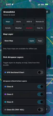
FAA Airspace Layers
Display Class B, C, D, and E airspace boundaries, TFRs, restricted and prohibited areas, and obstructions directly on the map. Know your airspace at a glance.
Proximity Alerts
Configurable caution and warning rings notify you when aircraft or drones enter your defined range and altitude thresholds. Alerts escalate with audio tones and haptic feedback so you never miss a conflict.
skyAlert Integration
Connected to a uAvionix skyAlert? Sync your alert thresholds, adjust traffic alarm range, altitude, volume, and LED brightness — all from within the app.
Aviation-Grade Map
Built on Apple MapKit with satellite and hybrid views. Range rings, velocity vectors, and operator position lines give you full situational context at a glance.
Weather
Current conditions, wind, visibility, and minute-by-minute precipitation forecasts powered by Apple WeatherKit. Weather alerts keep you informed of changing conditions.
Offline Capable
Download topo map tiles and FAA airspace data for your area. Remote ID scanning works entirely via Bluetooth with no internet connection required.
Built for the Field
Dark theme optimized for outdoor use. Designed for drone pilots, manned aircraft pilots, airport operations, and airspace safety professionals.
Terms
Use of this app is subject to the Apple Standard End User License Agreement (EULA):
https://www.apple.com/legal/internet-services/itunes/dev/stdeveula/
Note: ADS-B traffic requires a compatible GDL-90 receiver (such as a uAvionix skyAlert, Stratux, SkyEcho, or similar). Remote ID detection requires iOS 15+ and Bluetooth.
Safety and technology
Found in the app by AppBrain- Price
- Free
- App size
- 2.98 MB
- Content rating
- Everyone
Technologies used by DroneDAA by uAvionix
Releases
Updates seen on the App Store- Version
- 1.3.0
- Launched
- April 2026
No changelog data
Alternatives
Similar apps and more from CAVU Consulting LLCAlternatives to DroneDAA by uAvionix


More from CAVU Consulting LLC

Rankings
App Store top chartsApp Store Rankings for DroneDAA by uAvionix
About the app and developer
About DroneDAA by uAvionix
DroneDAA by uAvionix is an utilities app developed by CAVU Consulting LLC.
User Ratings
DroneDAA by uAvionix is rated 5.00 out of 5 stars. The rating is based on 2 ratings.
App Information
DroneDAA by uAvionix is freely available from the App Store. The app size is 2.98 MB. The latest version available is 1.3.0. The last update was on September 17, 2026.
Technical Requirements
The app has a content rating of Everyone. The app has been available on the App Store since April 2026.
Developer information for CAVU Consulting LLC
Address: