

Elevato
Elevato is made and published by TUOMAS JOHANNES VALTONEN. AppBrain is an independent app data site and isn't affiliated with TUOMAS JOHANNES VALTONEN. The app name, icon, screenshots and description belong to TUOMAS JOHANNES VALTONEN and are shown as published on the App Store.
AppBrain's verdict
- Rating on App Store
- 4.00
- 2 ratings
- Last updated
- March 18, 2026
- Size
- 37.3 MB
It doesn't have enough ratings yet to judge what users think.
User feedback
Ratings and reviews on the App StoreComments on Elevato for iOS
We don't have enough comments to show example comments. Please check back later.
Store listing
By TUOMAS JOHANNES VALTONEN, from the App Store


Description by TUOMAS JOHANNES VALTONEN Written by the developer, not by AppBrain. Click to read.
Ever wonder about your current elevation? Want to remember that stunning viewpoint? Curious if that distant mountain is actually visible? Or maybe you’re intrigued by the depth of the ocean floor? Elevato is your ultimate elevation companion!
Designed for outdoor enthusiasts, hikers, pilots, photographers, scientists, and the endlessly curious, Elevato delivers accurate elevation data and powerful visibility tools—right on your iPhone. It uses Copernicus DEM (30m resolution) for land and GEBCO 2024 Grid for oceans and polar regions.
Key Features:
Instant Elevation & Location: See your current altitude and location at a glance. Enjoy dynamic backgrounds that shift with your elevation—from mountain scenes to coastal views.
Global Elevation Lookup: Tap anywhere on the map to instantly find the elevation of that point—land elevation, seabed depth (bathymetry), and polar ice height included.
Save Favorite Spots: Mark important locations like peaks, viewpoints, or trailheads with a tap. Name them, manage your list, and view saved spots with their recorded altitudes on the map.
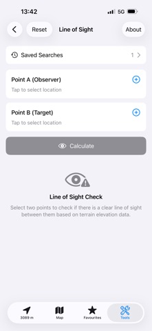
Unique Visibility Calculator: Go beyond altitude—see if distant objects are visible with a tool that considers:
Earth's curvature and atmospheric refraction.
Observer height, object height, and distance inputs.
Highest Altitude Record: Automatically track the highest point you've reached (toggle this feature in Settings).
Download Elevato and explore the vertical world— from the highest peaks to the deepest ocean trenches—with confidence.
Safety and technology
Found in the app by AppBrain- Price
- Free
- App size
- 37.3 MB
- Content rating
- Everyone
Technologies used by Elevato
Releases
Updates seen on the App Store- Version
- 2.2.2
- Launched
- May 2025
No changelog data
Alternatives
Similar apps and more from TUOMAS JOHANNES VALTONENAlternatives to Elevato


Rankings
App Store top chartsApp Store Rankings for Elevato
About the app and developer
About Elevato
Elevato is an utilities app developed by TUOMAS JOHANNES VALTONEN.
What is the rating of Elevato?
Elevato is rated 4.00 out of 5 stars, based on 2 ratings.
Is Elevato free?
Elevato is free. The app size is 37.25 MB. The latest version available is 2.2.2. The last update was on March 18, 2026.
What are the requirements for Elevato?
The app has a content rating of Everyone. The app has been available on the App Store since May 2025.
Developer information for TUOMAS JOHANNES VALTONEN
Address: