

FarShot - Distance Estimator
FarShot - Distance Estimator is made and published by LOKESH KUMAR GUTTAPALEM. AppBrain is an independent app data site and isn't affiliated with LOKESH KUMAR GUTTAPALEM. The app name, icon, screenshots and description belong to LOKESH KUMAR GUTTAPALEM and are shown as published on the App Store.
AppBrain's verdict
- Rating on App Store
- 3.60
- 5 ratings
- Last updated
- May 12, 2026
It doesn't have enough ratings yet to judge what users think.
Rankings
App Store top chartsApp Store Rankings for FarShot - Distance Estimator
Competitors
Similar apps and more from LOKESH KUMAR GUTTAPALEMAlternatives to FarShot - Distance Estimator


More from LOKESH KUMAR GUTTAPALEM

Releases
Updates seen on the App Store- Version
- 1.0.4
- Launched
- April 2026
No changelog data
User feedback
Ratings and reviews on the App StoreComments on FarShot - Distance Estimator for iOS
We don't have enough comments to show example comments. Please check back later.
Technology
Found in the app by AppBrain- Price
- Free
- App size
- 48.4 MB
- Content rating
- Everyone
Technologies used by FarShot - Distance Estimator
About the app and developer
About FarShot - Distance Estimator
FarShot - Distance Estimator is an utilities app developed by LOKESH KUMAR GUTTAPALEM.
User Ratings
FarShot - Distance Estimator is rated 3.60 out of 5 stars. The rating is based on 5 ratings.
App Information
FarShot - Distance Estimator is freely available from the App Store. The app size is 48.39 MB. The latest version available is 1.0.4. The last update was on May 12, 2026.
Technical Requirements
The app has a content rating of Everyone. The app has been available on the App Store since April 2026.
Developer information for LOKESH KUMAR GUTTAPALEM
Address:
Store listing
By LOKESH KUMAR GUTTAPALEM, from the App Store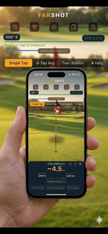




Description by LOKESH KUMAR GUTTAPALEM Written by the developer, not by AppBrain. Click to read.
FarShot turns your iPhone into a distance, height and width estimator — no laser rangefinder, no additional hardware, no internet required for core measurements.
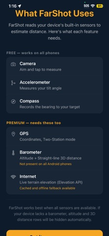
Point your phone at the base of any target, wait for the steadiness indicator to turn green, and tap. FarShot uses your device's accelerometer, gyroscope, compass, barometer, and GPS to calculate how far away something is — with typical accuracy of ±2–5% for targets between 5 and 200 metres.
HOW IT WORKS
FarShot measures the angle your phone tilts down toward a target, combined with your known camera height above the ground, and calculates the distance using trigonometry. It works best in the same conditions a laser rangefinder does — a clear line of sight to the base of a target.
CORE FEATURES (FREE)
Single-tap distance measurement — point, hold steady, tap
Live steadiness indicator — green means you're ready to shoot
Real-time angle and live distance preview while you aim
Compass bearing to every target
Camera calibration — calibrate once for significantly improved accuracy
Confidence score on every reading (HIGH / MODERATE / LOW)
Zoom control — pinch-to-zoom or step controls
Watermarked photo snapshot with measurement overlay
Dark and light mode
Tutorial and guided onboarding
PREMIUM FEATURES
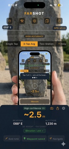
3-Tap Average — three readings, outliers rejected, trimmed mean result
Long-Press Precision mode — 75-sample deep burst for distant targets
Height Estimator — measure object height in two taps
Width Estimator — measure object width using bearing spread
Two-Station Triangulation — walk a baseline, triangulate from two positions
Slope-corrected distance — uses real terrain elevation via Open-Meteo API
Straight-line 3D distance — through-air distance accounting for elevation change
Terrain / Walking distance — 25-point surface path calculation
Altitude display (barometric)
GPS coordinates of measured target
Imperial (feet/miles) and yards unit support
Measurement history with notes and labels
Waypoints — save, name, and navigate back to measured targets
Full-resolution annotated snapshot export
CSV export of measurement history
Voice readout of results
MEASUREMENT MODES EXPLAINED
Single Tap — the fastest reading. Perfect for quick field estimates.
3-Tap Average — three readings averaged with outlier rejection. More reliable for precision work.
Long-Press Precision — hold the shutter for 2.5 seconds. FarShot collects a deep 75-sample burst for the most stable angle reading possible.
Height Estimator — tap the base of an object, then its top. FarShot calculates the height.
Width Estimator — tap for distance, then sweep left and right edge bearings. FarShot calculates the span.
Two-Station — record a bearing, walk a known baseline, record a second bearing. FarShot triangulates the target position using the sine rule.
PRIVACY FIRST
No account. No login. No tracking. No analytics. All measurements stay on your device. GPS coordinates sent to the elevation API are rounded for privacy. Nothing goes to any LokLogix server — ever.
ACCURACY NOTES
Typical accuracy: ±2–5% at 5–200 m on flat ground with a calibrated camera height. Accuracy improves with calibration, Precision mode, and the 3-Tap Average. The app is not a certified measurement instrument and results should not be used for construction, legal, or safety-critical purposes.
WHO IS FARSHOT FOR?
Hunters estimating shot distance in the field. Golfers checking yardages without a dedicated rangefinder. Hikers mapping terrain. Photographers calculating depth of field distances. Anyone who needs a quick, reasonably accurate distance estimate from their phone.
Terms of Use: https://loklogix.com/terms-of-use
Support: Support@LokLogix.com