

FireRadar - Wildfire Map
FireRadar - Wildfire Map is made and published by David Azancot. AppBrain is an independent app data site and isn't affiliated with David Azancot. The app name, icon, screenshots and description belong to David Azancot and are shown as published on the App Store.
AppBrain's verdict
- Last updated
- August 18, 2026
- Size
- 4.84 MB
User feedback
Ratings and reviews on the App StoreComments on FireRadar - Wildfire Map for iOS
We don't have enough comments to show example comments. Please check back later.
Store listing
By David Azancot, from the App Store

Description by David Azancot Written by the developer, not by AppBrain. Click to read.
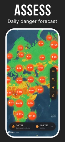
Explore recent satellite detections, view burned areas and display wildfire danger for today or tomorrow. Select any available item to see more context, including the detection date, satellite source, confidence level and local conditions when available.
A GLOBAL WILDFIRE MAP
View recent thermal detections on a worldwide map. Nearby points may be grouped to keep the map readable when several signals are observed in the same area.
Move freely across the map, zoom into a region and quickly switch from a global overview to a local inspection.
WILDFIRE DANGER
Enable the wildfire danger layer to review conditions for today or tomorrow. The color scale helps you quickly identify areas where fire danger may be higher.
The layer is optional, allowing you to display it only when needed and keep the map clear.
BURNED AREAS
Display recently burned surfaces across Europe, the Mediterranean region and the rest of the world, depending on data availability. Colors make these areas easy to identify without hiding the main geographic references.
DETAILED INFORMATION
Select a detection to review available details:
• detection date and time;
• satellite or instrument;
• confidence level;
• location;
• local weather conditions when available.
STATISTICS AND COMPARISONS
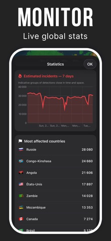
Track changes in detections over several days and compare the countries or regions most affected. Charts make it easier to identify increases or decreases in detected activity.
MULTIPLE MAP STYLES
Switch between standard, satellite and hybrid maps to match the terrain. Roads, cities and key geographic references remain visible to help you interpret the information.
A SIMPLE INTERFACE
Environmental layers are disabled by default and can be enabled from the map menu. This gives you full control over the information displayed.
FireRadar is available in English and French.
SATELLITE DATA
FireRadar uses data from sources including NASA FIRMS, VIIRS, MODIS, GWIS and EFFIS. Availability, update frequency and coverage may vary by region and provider.
IMPORTANT INFORMATION
A satellite detection represents a thermal anomaly observed from space. It does not necessarily confirm a wildfire on the ground. Incidents grouped in the app are estimates based on detections that are close in location and time.
Data may be delayed, incomplete, obscured by clouds or temporarily unavailable. Some regions may provide more information than others.
FireRadar is an information and visualization tool. It is not a replacement for official alerts, local authorities, weather agencies or emergency services.
In an immediate emergency, always follow instructions from the relevant authorities and use your country’s official emergency channels.
Safety and technology
Found in the app by AppBrain- Price
- Free
- App size
- 4.84 MB
- Content rating
- Everyone
Technologies used by FireRadar - Wildfire Map
Releases
Updates seen on the App Store- Version
- 1.0.1
- Launched
- August 2026
No changelog data
Alternatives
Similar apps and more from David AzancotMore from David Azancot


Rankings
App Store top chartsApp Store Rankings for FireRadar - Wildfire Map
About the app and developer
About FireRadar - Wildfire Map
FireRadar - Wildfire Map is a news app developed by David Azancot.
User Ratings
The app has no ratings yet.
App Information
FireRadar - Wildfire Map is freely available from the App Store. The app size is 4.84 MB. The latest version available is 1.0.1. The last update was on August 18, 2026.
Technical Requirements
The app has a content rating of Everyone. The app has been available on the App Store since August 2026.
Developer information for David Azancot
Address:
Frequently asked questions about FireRadar - Wildfire Map
Is FireRadar - Wildfire Map free?
Yes. FireRadar - Wildfire Map is free on the App Store.
Is FireRadar - Wildfire Map still available?
Yes. FireRadar - Wildfire Map is on the App Store, and the last update we saw was on August 18, 2026.
How large is FireRadar - Wildfire Map?
FireRadar - Wildfire Map is 4.84 MB.
Is FireRadar - Wildfire Map suitable for children?
App Store rates the content of FireRadar - Wildfire Map as suitable for everyone.
Who made FireRadar - Wildfire Map?
FireRadar - Wildfire Map was developed by David Azancot. It is listed in the news category on the App Store.