

Flight Navigator
Flight Navigator is made and published by Kazuhiro Ota. AppBrain is an independent app data site and isn't affiliated with Kazuhiro Ota. The app name, icon, screenshots and description belong to Kazuhiro Ota and are shown as published on the App Store.
AppBrain's verdict
- Last updated
- May 7, 2026
- Size
- 4.06 MB
User feedback
Ratings and reviews on the App StoreComments on Flight Navigator for iOS
We don't have enough comments to show example comments. Please check back later.
Store listing
By Kazuhiro Ota, from the App Store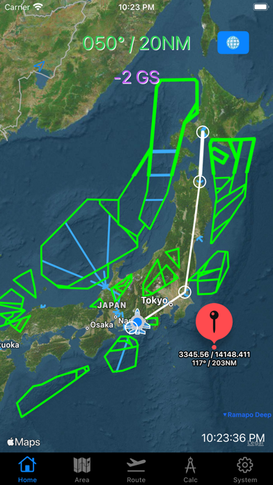


Description by Kazuhiro Ota Written by the developer, not by AppBrain. Click to read.
フライトナビゲーター
Flight Navigatorは、パイロットのフライトナビゲーションを助けるiPhoneアプリです。
このアプリは、フライトに必要な位置情報や空域の情報、そしてルートを簡単に把握できる便利なツールとなっています。
特に、ミリタリートレーニング/オペレーションに特化した設計がされており、補助アビオニクスとして活用できます。
主な特徴:
1. 位置情報と空域の情報:Flight Navigatorは、GPS機能を活用して現在の位置情報を提供します。さらに、地図や空域情報を提供し、飛行中の位置と周囲の状況を一目で把握することができます。
2. ルートプランニング:Flight Navigatorは、簡単なルートプランニング機能を提供します。出発地と経由FIX、目的地を入力することで、地図上にルートを表示します。
3. ミリタリーオペレーションに特化:Flight Navigatorは、ミリタリーオペレーションに必要な情報を提供します。常にBullseyeを基準にした自機位置を表示するほか、ピンを打った場所の座標、自機位置からの距離、Bullseyeからの距離、到達時間等を表示することが可能です。
ユーザー独自のエリアの入力が可能で、Bullseyeを基準にしたエリア作成も可能です。データはCSVファイルとしてファイルAppで管理できるため、AirDropを使用したデータのシェアが可能です。
【Flight Navigator】
Flight Navigator is an iPhone app designed to assist pilots in flight navigation.
This app serves as a convenient tool for easily accessing essential information such as position data, airspace details, and route visualization. It is specifically tailored for military training and operations, making it a valuable companion for aviators.
Key Features:
Position and Airspace Information: Flight Navigator utilizes GPS functionality to provide real-time position data. It also offers detailed maps and airspace information, allowing pilots to quickly grasp their location and surroundings during flight.
Route Planning: Flight Navigator offers a straightforward route planning feature. By inputting departure, waypoint (FIX), and destination point, the app displays the route on the map.
Specialized for Military Operations: Flight Navigator caters to the specific needs of military operations by providing essential information. It displays the user's position based on Bullseye reference, along with coordinates, distances from self to pinned locations, distances from Bullseye, and estimated time of arrival. Users can input custom areas and create zones based on Bullseye reference. The data can be managed as CSV files within the File app, enabling easy sharing of data via AirDrop.
[Map options]
You can pick "North up ", "Heading up mode" or any direction.
You can choose standard map (default) or satellite map.
[Radial/DME from Bulls Eye]
Label on the top shows Radial/DME from certain point which you put on the Bulls Eye window.
Bulls Eye coordinates must be filled with Latitude / Longitude DMM format in the system tab.
[Speed indicator]
GPS ground speed (GS knot) indicator is on bottom of Bulls Eye label.
[Annotation (Pin) options]
You can put a pin on the map with long tap.
Also you can remove a pin with 3-finger tap.
Main
→ The title which will be shown with one long tap.
Sub
→ The subtitle which will be shown with one another tap on the pin.
[Area Tab]
This tab is for making user optional flight area on the map.
You can make area from BE radial/DME, also available for making circled line.
Data is savable to File App as CSV data. You can pick those up either Area tab or Layer page.
[Layer page]
You can pick csv data from File App.
[Route Tab]
This tab is for making user optional flight route on the map.
Now, available for
- Japanese FIXs and NAVAIDs
- World VOR, TACAN, VORTAC
- Europe Free Route Airspace points
- US FIXs and NAVAIDs
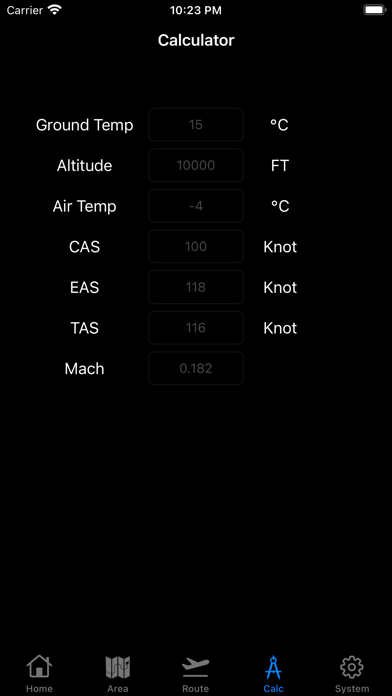
[Calculator Tab]
Fr me: From me
→ It shows Radial/DME from myself to pin.
Fr BE: From BullsEye
→ It shows Radial/DME from Bulls Eye to pin.
LatLon: Latitude Londitude
→ It shows Latitude and Londitude. minus means "South" or "West" respectively.
Time: MMM'SS
→ It shows time of flight to pin. (Distance devided by ground speed)
It does not include time of turn.
Safety and technology
Found in the app by AppBrain- Price
- Free
- App size
- 4.06 MB
- Content rating
- Everyone
Technologies used by Flight Navigator
Releases
Updates seen on the App Store- Version
- 2.3
- Launched
- July 2021
No changelog data
Alternatives
Similar apps and more from Kazuhiro OtaAlternatives to Flight Navigator





More from Kazuhiro Ota


Rankings
App Store top chartsApp Store Rankings for Flight Navigator
About the app and developer
About Flight Navigator
Flight Navigator is a navigation app developed by Kazuhiro Ota.
User Ratings
The app has no ratings yet.
App Information
Flight Navigator is freely available from the App Store. The app size is 4.06 MB. The latest version available is 2.3. The last update was on May 7, 2026.
Technical Requirements
The app has a content rating of Everyone. The app has been available on the App Store since July 2021.
Developer information for Kazuhiro Ota
Address: