

AppBrain's verdict
- Rating on App Store
- 4.60
- 5 ratings
- Last updated
- November 12, 2026
- Size
- 127.1 MB
It doesn't have enough ratings yet to judge what users think.
User feedback
Ratings and reviews on the App StoreComments on FO Maps: GeoPDF GPS Offline for iOS
We don't have enough comments to show example comments. Please check back later.
Store listing
By juan carlo abuin pampaloni, from the App StoreDescription by juan carlo abuin pampaloni Written by the developer, not by AppBrain. Click to read.
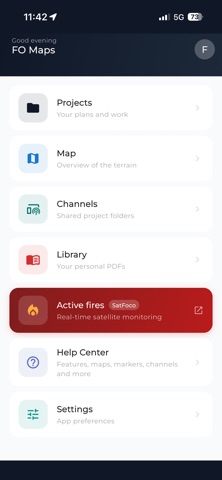
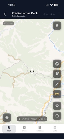
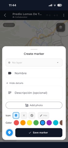
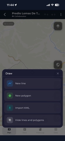
Load the georeferenced maps you already have and work on top of them: drop points, draw polygons, measure distances and areas, record your track, and export everything once you are back online. Nothing leaves your phone unless you want it to.
MAPS YOU ALREADY HAVE
· GeoPDF from QGIS, ArcGIS, Global Mapper and the USGS US Topo series
· MBTiles and georeferenced images
· Several maps per project, with adjustable opacity
· Generate a GeoPDF from the app to share
ON THE MAP
· Instrument panel: compass, bearing, coordinates, altitude and scale bar
· Four GPS modes, from center-only to follow with compass
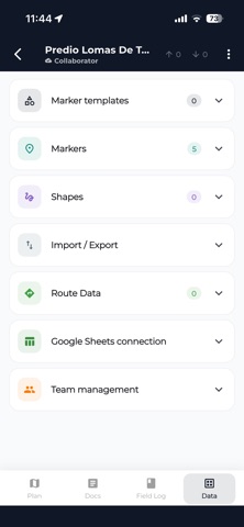
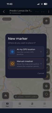
· Markers with your own templates, multiple photos, and GPS or manual coordinates
· Polygon and polyline drawing three ways: crosshair, freehand and GPS track
· Layers with visibility, color and icon
· Distance and area measurement
TRACKS
· Record your track with altitude at every point
· Take photos with notes as you walk: each one is pinned to that exact moment
· Play the track back on the map, pausing at every photo
· Export it as a vertical video to share
GETTING DATA OUT
· KML and KMZ with embedded photos, layers as folders and each point's real icon
· GPX with per-point timestamps
· PDF reports of the map with its markers
· Google Sheets, synced automatically
· Backup to your own Google Drive
· Save any export straight to your phone
TEAMS
· Channels: your crew joins with a code, no accounts to create
· Publish projects and follow the activity wall
· Sync across your own devices
MAPS AND WEATHER
· Downloadable OpenStreetMap base map for use with no signal, up to 100 km
· Hillshade and topographic styles
· 9-day forecast and alerts for heat, cold, rain, snow, wind and UV
· Discover: a catalog of maps published by organizations, free and without an account
17 languages, including right-to-left support.
PLANS
Free: maps, drawing, markers and export, with ads.
Explorer: hillshade and topographic styles, offline base map, weather, no ads.
Pro: everything above plus sync, channels and team collaboration.
Built with real crews: forestry roads, wildlife surveys, land surveys, and installations where there is no signal.
Support: contacto@faenaoffline.com
Web: https://faenaoffline.com/maps/
---
Terms of Use (EULA): https://www.apple.com/legal/internet-services/itunes/dev/stdeula/
Privacy Policy: https://faenaoffline.com/privacy/
Safety and technology
Found in the app by AppBrain- Price
- Free
- App size
- 127.1 MB
- Content rating
- Everyone
Technologies used by FO Maps: GeoPDF GPS Offline
Releases
Updates seen on the App Store- Version
- 2.1.3
- Launched
- March 2026
No changelog data
Alternatives
Similar apps and more from juan carlo abuin pampaloniAlternatives to FO Maps: GeoPDF GPS Offline




Rankings
App Store top chartsApp Store Rankings for FO Maps: GeoPDF GPS Offline
About the app and developer
About FO Maps: GeoPDF GPS Offline
FO Maps: GeoPDF GPS Offline is a productivity app developed by juan carlo abuin pampaloni.
User Ratings
FO Maps: GeoPDF GPS Offline is rated 4.60 out of 5 stars. The rating is based on 5 ratings.
App Information
FO Maps: GeoPDF GPS Offline is freely available from the App Store. The app size is 127.06 MB. The latest version available is 2.1.3. The last update was on November 12, 2026.
Technical Requirements
The app has a content rating of Everyone. The app has been available on the App Store since March 2026.
FO Maps: GeoPDF GPS Offline is made and published by juan carlo abuin pampaloni. AppBrain is an independent app data site and isn't affiliated with juan carlo abuin pampaloni. The app name, icon, screenshots and description belong to juan carlo abuin pampaloni and are shown as published on the App Store.
Developer information for juan carlo abuin pampaloni
Address: