

GPS Camera 55. Field Survey
GPS Camera 55. Field Survey is made and published by Kalimex-Consulting s.r.o. @Blocoware & Stanislav Dvoychenko. AppBrain is an independent app data site and isn't affiliated with Kalimex-Consulting s.r.o. @Blocoware & Stanislav Dvoychenko. The app name, icon, screenshots and description belong to Kalimex-Consulting s.r.o. @Blocoware & Stanislav Dvoychenko and are shown as published on the App Store.
AppBrain's verdict
EstablishedLoved by users- Best rank
- #23
- Top Grossing, Russia
- Rating on App Store
- 4.70
- 2,798 ratings
- Last updated
- September 27, 2026
Users love it: 4.7 stars from 2,798 ratings. Its best ranking is #23 in Top Grossing, Navigation in Russia.
Rankings
App Store top charts- Highest rank
- #23
- Chart
- Top Grossing
- Navigation
- Country
- Russia
Competitors
Similar apps and more from Kalimex-Consulting s.r.o. @Blocoware & Stanislav DvoychenkoAlternatives to GPS Camera 55. Field Survey


More from Kalimex-Consulting s.r.o. @Blocoware & Stanislav Dvoychenko
 Compass 55. Map & GPS kit.
 Taximeter. GPS taxi cab meter.
 Planimeter 55. Measure on map.

Releases
Updates seen on the App Store- Version
- 5.4
- Launched
- December 2018
No changelog data
User feedback
Ratings and reviews on the App StoreComments on GPS Camera 55. Field Survey for iOS
We don't have enough comments to show example comments. Please check back later.
Technology
Found in the app by AppBrain- Price
- Free
- App size
- 90.6 MB
- Content rating
- Everyone
Technologies used by GPS Camera 55. Field Survey
About the app and developer
About GPS Camera 55. Field Survey
GPS Camera 55. Field Survey is a navigation app developed by Kalimex-Consulting s.r.o. @Blocoware & Stanislav Dvoychenko.
User Ratings
GPS Camera 55. Field Survey is rated 4.70 out of 5 stars. The rating is based on 2.8 thousand ratings.
App Information
GPS Camera 55. Field Survey is freely available from the App Store. The app size is 90.57 MB. The latest version available is 5.4. The last update was on September 27, 2026.
Technical Requirements
The app has a content rating of Everyone. The app has been available on the App Store since December 2018.
Developer information for Kalimex-Consulting s.r.o. @Blocoware & Stanislav Dvoychenko
Frequently asked questions about GPS Camera 55. Field Survey
Is GPS Camera 55. Field Survey free?
Yes. GPS Camera 55. Field Survey is free on the App Store.
Is GPS Camera 55. Field Survey still available?
Yes. GPS Camera 55. Field Survey is on the App Store, and the last update we saw was on September 27, 2026.
How large is GPS Camera 55. Field Survey?
GPS Camera 55. Field Survey is 90.57 MB.
Is GPS Camera 55. Field Survey suitable for children?
App Store rates the content of GPS Camera 55. Field Survey as suitable for everyone.
How do people rate GPS Camera 55. Field Survey?
GPS Camera 55. Field Survey scores 4.70 out of 5 stars, from 2,798 ratings on the App Store.
Who made GPS Camera 55. Field Survey?
GPS Camera 55. Field Survey was developed by Kalimex-Consulting s.r.o. @Blocoware & Stanislav Dvoychenko. It is listed in the navigation category on the App Store.
What are the best alternatives to GPS Camera 55. Field Survey?
People looking at GPS Camera 55. Field Survey also look at these navigation apps: My GPS Coordinates °, Coordinates – GPS Converter, Map Plus, GPS & Maps: Location Tracker, Tomstrails GPS UTM.
Store listing
By Kalimex-Consulting s.r.o. @Blocoware & Stanislav Dvoychenko, from the App Store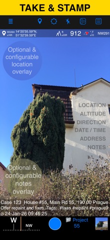



Description by Kalimex-Consulting s.r.o. @Blocoware & Stanislav Dvoychenko Written by the developer, not by AppBrain. Click to read.
LOCATION OVERLAY
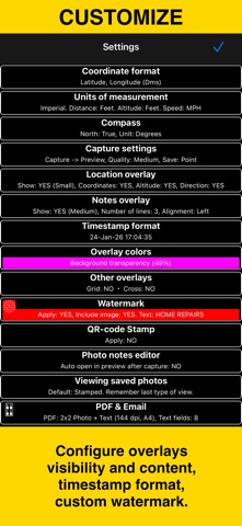
Supports decimal, DM, DMS, UTM, and MGRS coordinate formats.
True or magnetic heading, in degrees or mils.
Accuracy and altitude in feet or meters.
CAMERA AND CAPTURE SETTINGS
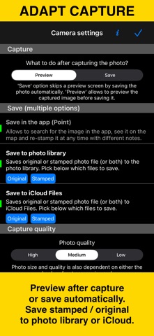
Save photos automatically or open in preview to annotate before saving.
Option to save a copy to the photo library — original, stamped, or both.
Record location-aware field video with map, QR code, watermark, speed, and motion overlays, then replay recordings in the app. The basic version stores one video and exports a branded clip of up to 15 seconds.
ANNOTATE AND COMMENT
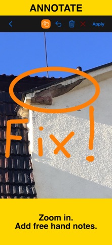
Before or after saving, zoom in/out and draw directly on the photo using your finger or Apple Pencil.
Crop, resize, rotate, or tilt the photo before or after saving.
Notes overlay supports Title, Note, Tags/Folder, and Address.
Address can be auto-filled from GPS or entered manually.
Edit notes and add annotations later (MENU > POINTS > tap an image).
Tapping a point row opens the editor, where you can add an audio note.
Timestamps support many formats and languages.
Scan QR codes, barcodes, or text and use the result for the title or note field.
WATERMARK
The Pro Pack upgrade removes the basic version watermark and allows you to set up a watermark with your own image, text, and colors, if needed.
SHARE AND EXCHANGE
Share multiple points via MENU > POINTS, or entire collections via MENU > POINT COLLECTIONS.
Images can be shared with or without location/notes text, and with or without overlays.
Photo filenames can include title, note, address, tags/folder name, collection, coordinates, altitude, heading, or capture date.
To transfer complete points and images to another device, use KMZ (Google Earth archive) — includes photos, notes, annotations, and audio.
PDF REPORTS
Generate and share PDF documents for the selected photos/points or whole collection/folder, with options for the number of images per page and photo descriptions.
ORGANIZE, SEARCH & SORT
You can organize images into collections/folders. Existing images/points can be moved between collections.
Search by notes, address, or tags; filter by creation month; sort by proximity; or show only one collection.
IMPORT
Import photos from your library. The app reads TIFF/EXIF/GPS/IPTC metadata to restore location, direction, and notes for the stamp.
NAVIGATE
Navigate back to any saved photo/point from its editor.
MAP VIEW
Review any saved photo/point and its location on the map.
== PRO PACK UPGRADE ==
You can do a lot with the basic functions in the app. The PRO PACK upgrade adds:
- Ability to create additional point/image collections.
- Enables sharing of more than 5 points/images at once.
- Export/import capabilities — in particular, KMZ export/import enables transfer of collections or selected waypoints between devices.
- Ability to save hand-drawn annotations for the image.
- Crop, resize, rotate, or tilt the photo before or after saving.
- Extra protection of your work and privacy with PIN code or biometric-based access options.
- Removes the basic version watermark and allows you to apply a custom watermark with your image, text, and colors.
- Unlimited saved videos and full-length stamped or original video exports.
Terms of Use: https://www.apple.com/legal/internet-services/itunes/dev/stdeula/