

GPS Map Camera: MapProof
GPS Map Camera: MapProof is made and published by Sourav Debnath. AppBrain is an independent app data site and isn't affiliated with Sourav Debnath. The app name, icon, screenshots and description belong to Sourav Debnath and are shown as published on the App Store.
AppBrain's verdict
- Last updated
- August 24, 2026
Rankings
App Store top chartsApp Store Rankings for GPS Map Camera: MapProof
Competitors
Similar apps and more from Sourav Debnath


Releases
Updates seen on the App Store- Version
- 1.0
- Launched
- August 2026
No changelog data
User feedback
Ratings and reviews on the App StoreComments on GPS Map Camera: MapProof for iOS
We don't have enough comments to show example comments. Please check back later.
Technology
Found in the app by AppBrain- Price
- Free
- App size
- 97.1 MB
- Content rating
- Everyone
Technologies used by GPS Map Camera: MapProof
About the app and developer
About GPS Map Camera: MapProof
GPS Map Camera: MapProof is a photo & video app developed by Sourav Debnath.
What is the rating of GPS Map Camera: MapProof?
GPS Map Camera: MapProof has no ratings yet.
Is GPS Map Camera: MapProof free?
GPS Map Camera: MapProof is free. The app size is 97.15 MB. The latest version available is 1.0. The last update was on August 24, 2026.
What are the requirements for GPS Map Camera: MapProof?
The app has a content rating of Everyone. The app has been available on the App Store since August 2026.
Developer information for Sourav Debnath
Address:
Store listing
By Sourav Debnath, from the App Store


Description by Sourav Debnath Written by the developer, not by AppBrain. Click to read.
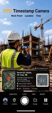
It is a geotag camera and a date stamp camera in one app. Capture travel proof, field surveys, real estate visits and site reports with the location locked into the image.
WHAT YOU GET
• Live GPS map overlay on photos and video
• Geotag photos with latitude, longitude and address
• Date stamp and timestamp on every capture
• Compass, altitude and weather on the stamp
• Custom layouts, notes and logo
• Manual pin on the map when GPS is weak
• Front and rear camera, grid, flash, timer
WHO IT IS FOR
Travelers, surveyors, engineers, inspectors, real estate agents, journalists and anyone who needs proof of where and when a photo was taken.
HOW IT WORKS
Open the app, allow location, pick a stamp, and shoot. Your geotag, map, date and location stamp are applied as you capture. Share instantly or save stamped and original copies.
GPS Map Camera Timestamp is the geotag photos and date stamp camera for work and travel — worldwide.
Privacy: location is used to stamp your media. See the in-app privacy policy for details.
Privacy Policy: https://sites.google.com/view/ps-map-camera-timestamp/home
Terms of Use (EULA): https://www.apple.com/legal/internet-services/itunes/dev/stdeula/