

Happy Prospector: Offline Maps
Happy Prospector: Offline Maps is made and published by Blueprint Industries Pty Ltd. AppBrain is an independent app data site and isn't affiliated with Blueprint Industries Pty Ltd. The app name, icon, screenshots and description belong to Blueprint Industries Pty Ltd and are shown as published on the App Store.
AppBrain's verdict
- Last updated
- August 17, 2026
Rankings
App Store top chartsApp Store Rankings for Happy Prospector: Offline Maps
Competitors
Similar apps and more from Blueprint Industries Pty LtdMore from Blueprint Industries Pty Ltd

Releases
Updates seen on the App Store- Version
- 2.6.81
- Launched
- May 2026
No changelog data
User feedback
Ratings and reviews on the App StoreComments on Happy Prospector: Offline Maps for iOS
We don't have enough comments to show example comments. Please check back later.
Technology
Found in the app by AppBrain- Price
- Free
- App size
- 67.4 MB
- Content rating
- Everyone
Technologies used by Happy Prospector: Offline Maps
About the app and developer
About Happy Prospector: Offline Maps
Happy Prospector: Offline Maps is a navigation app developed by Blueprint Industries Pty Ltd.
User Ratings
The app has no ratings yet.
App Information
Happy Prospector: Offline Maps is freely available from the App Store. The app size is 67.39 MB. The latest version available is 2.6.81. The last update was on August 17, 2026.
Technical Requirements
The app has a content rating of Everyone. The app has been available on the App Store since May 2026.
Developer information for Blueprint Industries Pty Ltd
Address:
Store listing
By Blueprint Industries Pty Ltd, from the App Store




Description by Blueprint Industries Pty Ltd Written by the developer, not by AppBrain. Click to read.
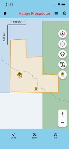
Designed for remote areas, the app lets you download maps and data before you go, then use essential mapping, GPS, tenement, find, track and reporting tools without mobile coverage or WiFi.
Use The Happy Prospector to explore WA prospecting data, browse directly to GPS coordinates, save classified field markers, record tracks, draw polygons, measure distances and create reports from your saved information.
Key Features
• Offline map use after downloads
• Standard WA base map
• High Resolution Maps
• Live and Pending WA Mining Tenements
• Mindex Gold locations
• Bedrock Geology
• Surface and Structures layers
• Browse directly to entered GPS coordinates
• Optional marker placement at a browsed GPS point
• Save Finds and field markers with notes
• Marker styles for finds, vehicles, camps and field features
• Premium Gate, Windmill, Dam, Dig Hole, Chained, Dryblowing, Pushed Area, Drill Hole, Costean and Mine markers
• Colour options for Find markers
• Depth and weight recording for applicable finds
• Go To navigation to saved Finds
• GPS track recording
• Track distance recording and live distance display
• Saved track distances shown in track lists
• Import Tracks from CSV/ZIP files
• Measure Distance tool
• Draw Polygons on the map
• Save, list, show/hide and delete Polygons
• 40E Report generation
• Finds Report generation
• Select a saved polygon or Live tenement as the report area
• Filter reports by date, exact area and marker type
• Report measured Finds or include all field markers
• Automatic tenement ID, lease and holder details where available
• Editable permit, lease, mineral, recovery and cost information
• Remembered prospector and permit-holder names
• Tools Settings menu
• GPS button mode settings
• Orientation lock settings
• Tap-map or centre-crosshair Measure mode
Free Version
The Free Version provides a practical way to get started.
Included in Free:
• Standard base map
• High Resolution Maps up to zoom level 16
• Live WA Mining Tenements display
• Mindex Gold locations
• Unlimited saved Finds, with the newest three available for selection
• Default, Car and Camp marker styles
• Browse to GPS Point
• Go To navigation to selectable Finds
• Save and reload the latest Tracks
• Track distance recording
• Draw Polygons from the Tools menu
Lite Version
Lite adds the main prospecting and tenement tools.
Included in Lite:
• Everything in Free
• Full High Resolution Map zoom range
• Live and Pending WA Mining Tenements
• Tenement identify, query and detail results
• Tenement highlighting on the map
• Yellow Find marker style
• Full saved Find selection
• Full saved Track loading
• Track pause and follow controls
Premium Version
Premium includes the complete Happy Prospector toolkit.
Included in Premium:
• Everything in Lite
• Gate, Windmill and Dam marker styles
• Dig Hole, Chained, Dryblowing, Pushed Area, Drill Hole, Costean and Mine marker styles
• Additional Find marker colours
• Drop Marker Pin
• Optional marker placement after browsing to a GPS point
• Measure Distance tool
• Saved Polygon management
• List, show/hide and delete saved Polygons
• 40E Report generation
• Finds Report generation
• Saved-polygon and Live-tenement report areas
• Measured-Finds or All-Markers report selection
• Track import from CSV/ZIP files
• Find import/export
• Track export
• Bedrock Geology
• Surface layer
• Structures layer
• Tools Settings
• GPS button mode settings
• Orientation lock settings
• Measure mode settings
The Happy Prospector is designed to be simple, practical and reliable in the field.
Download your maps and data before heading out, then use the app offline wherever your next Western Australian prospecting trip takes you.
Terms of Use (EULA): https://www.apple.com/legal/internet-services/itunes/dev/stdeula/