Korea Subway & Bus: Live Map is made and published by
Heechang Kim.
AppBrain is an independent app data site and isn't affiliated with Heechang Kim.
The app name, icon, screenshots and description belong to Heechang Kim and are shown as
published on the App Store.
About Korea Subway & Bus: Live Map
Korea Subway & Bus: Live Map is a navigation app developed by Heechang Kim.
User Ratings
The app has no ratings yet.
App Information
Korea Subway & Bus: Live Map is freely available from the App Store. The app size is 44.57 MB. The latest version available is 1.14. The last update was on October 23, 2026.
Technical Requirements
The app has a content rating of Everyone. The app has been available on the App Store since October 2026.
Description by Heechang Kim(from the App Store)
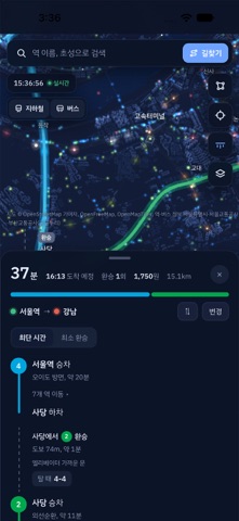
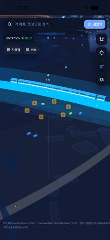
See where subway trains and buses are right now, directly on a 3D map. Watch trains and buses move between buildings and easily figure out when it's time to head out.
■ Real-Time Train Locations & Arrivals - See the actual locations of subway trains in the Seoul metropolitan area on the map. - Tap a station to check when the next train will arrive, with information such as "3 minutes away, 2 stations remaining." - Easily distinguish express trains and last trains.
■ First & Last Trains and Full Timetables - Check first and last train times for each station and direction. - Browse complete train timetables organized by time of day. - Instantly see "Service Ended for Today" when the last train has departed.
■ Real-Time Seoul Bus Locations - See where Seoul city buses are currently traveling on the roads. - Tap a bus stop to check estimated arrival times and how many stops away each bus is.
■ Route Planning - Select your departure and destination stations to find routes, including transfers, estimated travel times, and fares. - Get routes that avoid stations affected by service alerts, such as breakdowns or trains skipping stops.
■ Explore Stations & Routes in 3D - Explore underground rail depths, bridges across the Han River, and underwater tunnels in 3D. - Enable "Underground X-Ray" to see subway lines beneath the ground. - View station exit numbers and nearby bus stops. - Train roof colors indicate average crowding levels by time of day.
■ Nationwide Coverage - Explore subway lines and stations in Seoul and the surrounding metropolitan area, as well as Busan, Daegu, Gwangju, and Daejeon. - Outside Seoul, buildings, roads, and rivers are also displayed on a 3D map when connected to the internet. - Supports both iPhone and iPad. Enjoy a wider view of entire subway lines on iPad.
■ Your Privacy Matters - No account or registration required. - Your location is used only when you tap the "My Location" button. Location data is processed entirely on your device and is never sent to a server. - All other features remain available even if you deny location permission.
■ Important Information - When real-time data is unavailable, the app displays "Scheduled Service" estimates calculated from route information. - Real-time bus tracking currently supports Seoul city buses only. Support for other regions will be added gradually. - This is a free app supported by advertisements.
AppBrain offers valuable information about your app and those of your competitors. Join AppBrain for free and claim this app to view more ranking data, view history etc.
Each subscription will automatically renew 3 days before the expiration date for
the same time period. Subscriptions can be cancelled at any time before the renewal.