

Land Survey
Land Survey is made and published by Land Analysis Lab. AppBrain is an independent app data site and isn't affiliated with Land Analysis Lab. The app name, icon, screenshots and description belong to Land Analysis Lab and are shown as published on the App Store.
AppBrain's verdict
- Last updated
- October 12, 2026
Rankings
App Store top chartsApp Store Rankings for Land Survey
Competitors
Similar apps and more from Land Analysis LabAlternatives to Land Survey


More from Land Analysis Lab


Releases
Updates seen on the App Store- Version
- 3.0.1
- Launched
- January 2025
No changelog data
User feedback
Ratings and reviews on the App StoreComments on Land Survey for iOS
We don't have enough comments to show example comments. Please check back later.
Technology
Found in the app by AppBrain- Price
- Free
- App size
- 51.6 MB
- Content rating
- Everyone
Technologies used by Land Survey
About the app and developer
About Land Survey
Land Survey is an utilities app developed by Land Analysis Lab.
What is the rating of Land Survey?
Land Survey has no ratings yet.
Is Land Survey free?
Land Survey is free. The app size is 51.59 MB. The latest version available is 3.0.1. The last update was on October 12, 2026.
What are the requirements for Land Survey?
The app has a content rating of Everyone. The app has been available on the App Store since January 2025.
Developer information for Land Analysis Lab
Address:
Store listing
By Land Analysis Lab, from the App Store


Description by Land Analysis Lab Written by the developer, not by AppBrain. Click to read.
[Key Features]
▶ Area Survey
• Calculate area in real time by placing polygon vertices on the map one by one.
• Supports over 30 area units including sq m, sq km, ha, ac (acre), pyeong, and more.
• Offers a wide range of historical and traditional units such as arpent, perch, hide, stremma, and dunam.
▶ Distance Survey
• Measure total distance in real time by drawing a path on the map.
• Supports over 30 distance units including m, km, ft, mi, nautical mile (nmi), and more.
• Provides surveying, nautical, and historical units such as chain, link, fathom, furlong, rod, and more.
▶ Multiple Map Styles
• Freely switch between 4 map modes: Normal, Satellite, Hybrid, and Terrain.
▶ Precision Editing
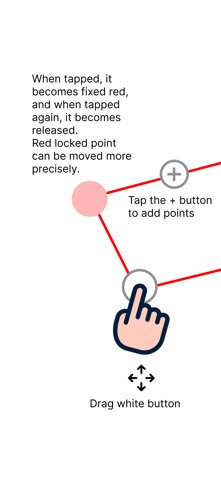
• Drag placed points to freely adjust their positions.
• Select a node and use the on-screen center target for precise positioning.
• Use the GPS current location button to instantly apply your current position as a survey point.
• Edit while referencing a Guide layer, and use the Snapping feature to align precisely to existing points and lines.
• Use the Undo feature to instantly revert mistakes.
▶ Review Mode
• Switch to review mode after editing to view distance labels on each segment.
• Toggle distance label visibility on or off.
▶ Save and Manage
• Save survey results to the Archive with a custom name.
• Load saved survey data anytime to re-edit or review.
• Quickly save or delete individual items with a slide gesture.
▶ File Export and Import
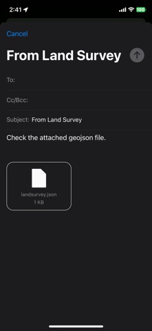
• Export survey data in GeoJSON and KML formats.
• Import GeoJSON and KML files created externally.
• Send survey data directly via email.
• Export individual items or all data at once.
▶ Location Search
• Place Search: Quickly find a desired location by address or place name.
• Coordinate Input: Enter latitude and longitude directly to navigate to a precise location.
▶ Multi-Language Support
• Supports 7 languages: English, Korean, Japanese, Chinese, Spanish, Hindi, and Arabic.
▶ Theme Settings
• Choose from Light, Dark, and System themes.
▶ Premium Purchase
• A one-time purchase removes all ads and unlocks a seamless experience with all features.
[Recommended For]
• Anyone who wants to quickly check land or real estate area on-site
• Anyone who wants to easily measure farmland, forest, or ranch area
• Anyone who wants to measure the distance of hiking trails, walking paths, or coastlines
• Anyone who needs quick surveying at construction, landscaping, or civil engineering sites
• Anyone who wants to share survey results in GeoJSON/KML or use them in GIS software
Start accurate surveying easily with Land Survey.