

LiveTerra is made and published by Shyam Steenhaut. AppBrain is an independent app data site and isn't affiliated with Shyam Steenhaut. The app name, icon, screenshots and description belong to Shyam Steenhaut and are shown as published on the App Store.
AppBrain's verdict
- Last updated
- September 18, 2026
Rankings
App Store top chartsApp Store Rankings for LiveTerra
Competitors
Similar apps and more from Shyam SteenhautMore from Shyam Steenhaut


Releases
Updates seen on the App Store- Version
- 1.2
- Launched
- September 2026
No changelog data
User feedback
Ratings and reviews on the App StoreComments on LiveTerra for iOS
We don't have enough comments to show example comments. Please check back later.
Technology
Found in the app by AppBrain- Price
- Free
- App size
- 7.06 MB
- Content rating
- Everyone
Technologies used by LiveTerra
About the app and developer
About LiveTerra
LiveTerra is a weather app developed by Shyam Steenhaut.
User Ratings
The app has no ratings yet.
App Information
LiveTerra is freely available from the App Store. The app size is 7.06 MB. The latest version available is 1.2. The last update was on September 18, 2026.
Technical Requirements
The app has a content rating of Everyone. The app has been available on the App Store since September 2026.
Developer information for Shyam Steenhaut
Address:
Store listing
By Shyam Steenhaut, from the App Store


Description by Shyam Steenhaut Written by the developer, not by AppBrain. Click to read.
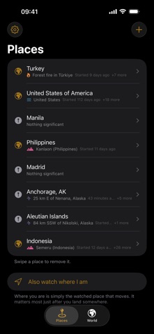
Add your home, the town your family lives in, or somewhere you are about to travel. LiveTerra gathers earthquakes, wildfires, storms, floods and volcanoes near each place, from the agencies that report them and the satellites that measure them.
You decide what "near" means. Every place gets its own radius, because a city and a mountain range are not the same question. A whole country can be watched too, and then its border decides instead of a distance.
You also decide what is worth an interruption. Per place, choose which event to hear about and how big an earthquake has to be. Only events the agencies grade as significant are ever sent.
Most days, nothing happens. Some places see something most weeks, many see nothing for months, and LiveTerra will not invent activity to look busy. A quiet list is a real answer, and it is the one you will see most often.
When something does happen, you get what the source actually published rather than a dot on a map. A storm carries its wind field and the track it has taken. An earthquake shows measured shaking from the USGS ShakeMap, not a circle worked out from the magnitude. A flood shows the alert area, and the smaller outline an analyst traced from a satellite image when there is one. A volcano shows its ash cloud, as observed and as forecast for the hours ahead. Under all of it, headlines from local publishers and a link to the full report.
Satellite heat detections sit in their own section and are never mixed in with the rest. NASA's satellites measure heat, not fires, so industry and farm burning show up as well. A detection is a weaker claim than a reported wildfire, and LiveTerra keeps that difference visible instead of rounding it away.
The second screen is the world. Everything the feeds report, drawn on one map, ranked by how significant it is, opening on your part of the world. Filter it by hazard, or switch from significant events to everything and watch the small earthquakes fill in.
LiveTerra is not a warning system. The agencies publish after the fact, sometimes hours after, and this app is only as quick as they are. Official warnings from your local authorities come first, and nothing here replaces them.
No account, no advertising and no tracking. Your places stay on your phone. With notifications on, the server is told a coarse grid of roughly 100 km squares, never a place name or an exact position.