

Mapio. is made and published by Nicolas Ahumada. AppBrain is an independent app data site and isn't affiliated with Nicolas Ahumada. The app name, icon, screenshots and description belong to Nicolas Ahumada and are shown as published on the App Store.
AppBrain's verdict
- Last updated
- October 3, 2026
- Size
- 36.2 MB
User feedback
Ratings and reviews on the App StoreComments on Mapio. for iOS
We don't have enough comments to show example comments. Please check back later.
Store listing
By Nicolas Ahumada, from the App Store




Description by Nicolas Ahumada Written by the developer, not by AppBrain. Click to read.
WHAT IT OPENS
Georeferenced PDFs (TerraGo GeoPDF and ISO 32000 PDFs with georeferencing), and TIF, TIFF and GeoTIFF: the drone orthomosaic, the agronomist's image, the survey map. Sent one by WhatsApp or email? Share it to Mapio.
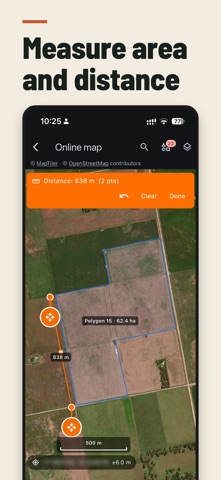
MEASURE
Distance and area by tapping the screen or walking the field with GPS, and centre pivots by centre, radius and fraction of the circle. Share a measurement or your location for free, with a Google Maps link.
MARK
Points with a name, a note, photos and the colour you pick, on your maps or the online map. Export as GPX and CSV.
ONLINE MAP
OpenStreetMap and high-resolution satellite imagery with town names, roads and your GPS, nothing to import. Search a town or a farm, or paste coordinates, which works even with no signal. With no data, what you already viewed still shows for up to 90 days.
SAVED FIELDS AND PIVOTS
Save a field once and use it on all your maps. Organise fields with folders and tags, and move or delete several at once. Import the ones you already have as KML, KMZ or shapefile, several files at a time (the fields from each file stay together in a folder named after it), and export them to QGIS, Auravant or the planter monitor.
ROTATIONAL GRAZING
Split the field into equal strips, rotate the fence line and read the instant stocking rate in head/ha and liveweight per hectare. Draw the laneway and mark the water point: every paddock with a way out to water, and how far the herd walks.
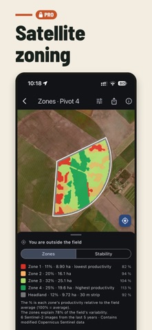
SATELLITE ZONING
Management zones from up to 5 years of Sentinel-2 imagery analysed for your field, with the headland separated from the centre and stability across seasons. Plus variable-rate prescriptions: several products per operation, the rate for each zone and the total to buy.
FIELD ANALYSIS (PRO)
Sentinel-2 indices by date (NDVI, EVI, NDRE, NDMI and 19 more), each with what it measures and its source. Water on one date, and the 1984-2021 Landsat history (JRC). Terrain from the Copernicus DEM: relative elevation and landscape position, with a test against 38 years of observed water. Each layer states its limits: terrain is a model and water on one day is not a flood risk. It all exports to QGIS.
ONLINE AND OFFLINE
Offline: opening your maps, locating yourself, measuring, paddock planning, marking points and exporting. Online: the satellite map the first time, place search, satellite zoning (do it before heading out) and field analysis, which downloads the imagery, terrain and water history every time you open it.
MAPIO PRO
The free version includes opening maps, locating yourself, measuring, marking points, saving fields and the online satellite map. Mapio Pro adds field analysis, satellite zoning, variable-rate prescriptions, grazing paddock planning, import and export, and an ad-free map.
• Mapio Pro Monthly — 1 month — US$ 0.99
• Mapio Pro Yearly — 1 year — US$ 7.99
Auto-renewable subscription. Payment is charged to your App Store account at confirmation of purchase. It renews automatically unless you cancel at least 24 hours before the end of the current period; your account is charged within 24 hours prior to the renewal. You can manage or cancel it in your account settings after purchase.
PRIVACY
No accounts and no servers of ours. Your location is processed on the phone and only leaves if you share it. The app's data is excluded from iCloud backup, so when you switch phones you have to import your maps again. The free version shows Google AdMob ads, and where the law requires it the app asks for your consent before the first one; you can change that answer in Settings.
Privacy policy: https://sites.google.com/view/mapio-privacy
Terms (Apple standard EULA): https://www.apple.com/legal/internet-services/itunes/dev/stdeula/
Data: Copernicus (EU/ESA), ESA WorldCover, EC JRC/Google and © OpenStreetMap contributors.
Safety and technology
Found in the app by AppBrain- Price
- Free
- App size
- 36.2 MB
- Content rating
- Everyone
Technologies used by Mapio.
Releases
Updates seen on the App Store- Version
- 1.0.27
- Launched
- July 2026
No changelog data
Alternatives
Similar apps and more from Nicolas AhumadaAlternatives to Mapio.


Also available on Google Play

Rankings
App Store top chartsApp Store Rankings for Mapio.
About the app and developer
About Mapio.
Mapio. is a navigation app developed by Nicolas Ahumada.
User Ratings
The app has no ratings yet.
App Information
Mapio. is freely available from the App Store. The app size is 36.17 MB. The latest version available is 1.0.27. The last update was on October 3, 2026.
Technical Requirements
The app has a content rating of Everyone. The app has been available on the App Store since July 2026.
Developer information for Nicolas Ahumada
Address:
Frequently asked questions about Mapio.
Is Mapio. free?
Yes. Mapio. is free on the App Store.
Is Mapio. still available?
Yes. Mapio. is on the App Store, and the last update we saw was on October 3, 2026.
How large is Mapio.?
Mapio. is 36.17 MB.
Is Mapio. suitable for children?
App Store rates the content of Mapio. as suitable for everyone.
Who made Mapio.?
Mapio. was developed by Nicolas Ahumada. It is listed in the navigation category on the App Store.
What are the best alternatives to Mapio.?
People looking at Mapio. also look at these navigation apps: MapNero: Offline GIS Maps, NomadTracks: GPS Map Tracker, Field Area Measure, Guru Maps - Offline Navigation, SEM Mobile.