Missouri Flood & Drought is a weather app developed by State of Missouri - Office of Administration.
What is the rating of Missouri Flood & Drought?
Missouri Flood & Drought is rated 5.00 out of 5 stars, based on 7 ratings.
Is Missouri Flood & Drought free?
Missouri Flood & Drought is free to download. The download size is 384.91 MB. The latest version available is 1.0.0. The last update was on February 25, 2026.
What are the requirements for Missouri Flood & Drought?
The app has a content rating of Everyone. The app has been available on the App Store since February 2026.
Description
STAY INFORMED. STAY SAFE. STAY CONNECTED.
The official mobile companion app for the Missouri Hydrology Information Center (MoHIC), developed in partnership with the Missouri Department of Natural Resources.
BORN FROM MISSOURI'S FLOOD EXPERIENCE
Missouri has faced devastating floods in recent decades, including 1993, 1998, 2011, and the historic 2019 flood that caused an estimated $20 billion in losses. The 2019 event kept locations on the Missouri River in a declared flood state for 279 days, demonstrating the critical need for better flood protection and resiliency.
In response, Governor Mike Parson established the Flood Recovery Advisory Working Group, leading to the creation of MoHIC, funded through the American Rescue Plan Act (ARPA). This app is part of Missouri's commitment to serving citizens during both flood and drought through accessible, user-friendly information.
REAL-TIME WATER MONITORING AT YOUR FINGERTIPS
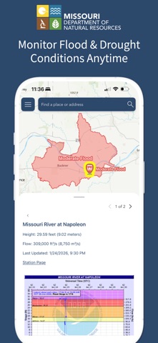
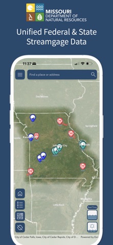
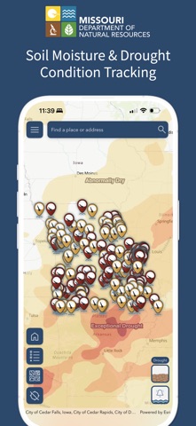
Access live data from MoDNR's streamgage network, federal agencies' streamgage networks and forecasts, and soil moisture sensors deployed across Missouri. Monitor water levels (stage) and flow rates (discharge) that directly impact flood and drought conditions in your community.
PERSONALIZED FLOOD NOTIFICATIONS
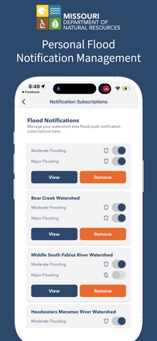
Subscribe to specific locations that matter to you for flood notifications Receive instant push notifications when flood conditions are detected in your designated areas Stay ahead of changing conditions with the National Weather Service National Water Model forecast integration Customize notifications based on your home, work, or other locations of interest COMPREHENSIVE MAPS AND DATA
View interactive flood and drought maps optimized for mobile Explore real-time and forecasted water conditions statewide Access statewide flood inundation mapping (FIM) Access authoritative data from trusted federal, state, and regional sources WHO BENEFITS?
Homeowners and renters in flood-prone areas Farmers and agricultural professionals monitoring drought Emergency managers and first responders Outdoor recreation enthusiasts Anyone concerned about Missouri's water conditions KEY FEATURES
Monitor flood and drought conditions anytime Curated map themes and data Real-time flood notifications Personal flood and notification management Consolidated streamgage readings from federal and state sources Soil moisture and drought condition tracking Flood forecast integration with the National Weather Service POWERED BY TRUSTED TECHNOLOGY
Built on the ArcGIS platform using cutting-edge mobile technology, this app delivers reliable, authoritative information when and where you need it. Data is continuously updated from Missouri's sensor and streamgage network and is paired with federal, state, and regional sources for the most accurate picture of water conditions.
YOUR WATER MONITORING COMPANION
Whether you need to monitor flood risk at your property, track drought conditions affecting your farm, coordinate emergency response, or simply stay informed about Missouri's rivers and streams, this app provides critical, real-time information to support better decisions.
Part of the Missouri Hydrology Information Center initiative. Developed by Esri in partnership with the Missouri Department of Natural Resources.
Each subscription will automatically renew 3 days before the expiration date for
the same time period. Subscriptions can be cancelled at any time before the renewal.