My Altitude: Chart & Compass is an overall app developed by Shenzhen Jirry Jirry Technology Co., Ltd..
Download Statistics
User Ratings
My Altitude: Chart & Compass is rated 4.00 out of 5 stars. The rating is based on 4 ratings.
App Information
My Altitude: Chart & Compass is FREE to download. The APK download size is 14.21 MB. The latest version available is 1.0.7. The last update was on June 25, 2026.
Technical Requirements
The app has a content rating of Everyone. The app has been available on Google Play January 2024.
Description
**Precise Measurement • Real-time Monitoring • Data Insights**
Altitude is a powerful professional altitude measurement app that integrates precise altitude measurement, a smart compass, and a watermark camera. Whether you're a mountaineering enthusiast, outdoor explorer, construction engineer, or geographer, this app provides you with accurate and reliable elevation data and practical tools.
**Core Features**
1. **Precise Altitude Measurement** * Real-time Altitude Monitoring: Uses device sensors to measure current altitude in real time. * Multi-unit Switching: Supports free switching between meters/feet to suit different preferences. * Accuracy Display: Shows measurement accuracy and GPS coordinates in real time. * Status Recognition: Intelligently identifies altitude status (Low/Medium/High/Extreme Altitude).
2. **Professional Data Analysis** * Historical Charts: Visualize altitude trends with support for time-range filtering. * Data Statistics: Automatically calculates key metrics like min, max, and average values. * Data Export: Supports CSV/JSON export for professional analysis. * Data Sharing: Instantly generates beautiful data cards to share with friends or teams.
3. **Integrated Compass** * Accurate Bearing: Displays precise bearing angle and direction in real time. * Coordinate Display: Shows current GPS coordinates (latitude/longitude) simultaneously. * Calibration Tool: Built-in professional calibration tool ensures compass accuracy.
**Professional Feature Details**
1. **Data Management** * History Log: Automatically saves all measurement data (up to 10,000 records). * Smart Filtering: Filter data by time range (1 hour/24 hours/7 days/30 days). * Data Cleanup: Supports batch cleanup of history to free storage. * Import/Export: Seamless data exchange with desktop software.
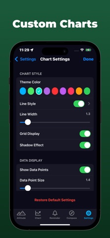
2. **Customizable Settings** * Multiple chart line styles (Straight/Curve/Step/Dashed). * Customizable chart color themes and line thickness. * Adjustable chart data point size and density. * Altitude Unit: Free switching between meters/feet.
3. **Smart Alert System** * Altitude Alerts: Get notified upon reaching a specific altitude. * Change Alerts: Monitors rapid altitude changes and sends notifications. * Custom Conditions: Supports multi-condition combined alerts. * Background Operation: Continuously monitors and alerts even while in the background. * Local Notifications: Receive alerts even offline.
4. **Data Sharing** * Share real-time altitude data cards. * Share historical data tables. * Share statistical chart images.
**Use Cases**
1. **Outdoor Adventure** * Mountain climbing height records and route planning. * Hiking altitude change monitoring. * Altitude sickness prevention and early warning. * Campsite elevation assessment.
2. **Engineering & Surveying** * Building height measurement and recording. * Topographic survey data collection. * Construction process height monitoring. * Project progress elevation verification.
3. **Education & Research** * Geography class teaching aid. * Scientific research data collection and analysis. * Environmental change altitude monitoring. * Student outdoor practice tool.
4. **Travel Logging** * Record altitude changes during travel. * Travel photos with altitude watermarks. * Trip height change statistics.
5. **Data Security**
* Local data storage protects privacy. * Data encrypted storage. * No mandatory network permissions required.
Download Altitude Pro now and begin your high-precision measurement journey!
Privacy Policy: https://compassnow.github.io/privacy.html Terms of use: https://compassnow.github.io/terms.html
Each subscription will automatically renew 3 days before the expiration date for
the same time period. Subscriptions can be cancelled at any time before the renewal.