Offline Topo Map is made and published by
Florian Zindel.
AppBrain is an independent app data site and isn't affiliated with Florian Zindel.
The app name, icon, screenshots and description belong to Florian Zindel and are shown as
published on the App Store.
About Offline Topo Map
Offline Topo Map is a navigation app developed by Florian Zindel.
What is the rating of Offline Topo Map?
Offline Topo Map has no ratings yet.
Is Offline Topo Map free?
Offline Topo Map costs $2.99. The app size is 3.34 MB. The latest version available is 1.0.1. The last update was on September 24, 2026.
What are the requirements for Offline Topo Map?
The app has a content rating of Everyone. The app has been available on the App Store since September 2026.
Description by Florian Zindel(from the App Store)
The topographic map that works where the signal doesn't.
Offline Topo Map brings OpenTopoMap, the free topographic rendering of OpenStreetMap data, to your iPhone and iPad. Contour lines, hill shading, peaks, huts and trails, exactly as thousands of hikers already use them in the browser. Then it lets you take the mountains with you: draw a rectangle over the area you are heading into, download every zoom level, and the map keeps working when your phone has no connection at all.
WHAT YOU GET
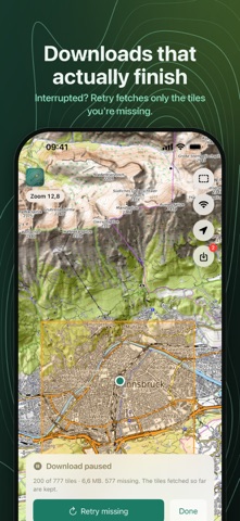
• Real topography — contour lines, shaded relief, summits, passes, huts, springs and marked trails from OpenStreetMap and SRTM elevation data. • Draw it, download it — tap the dashed rectangle, drag across the map, touch and hold to nudge it into place, then download zoom levels 0 to 17 in one go. • Know the size first — before anything is fetched you see the tile count and an estimated download size, so a careless swipe never turns into a gigabyte. • The offline switch — flip it and the map shows only what you have stored, with every saved area outlined. What you see is exactly what you will have on the mountain. • Downloads that finish — lock the phone or lose the connection and nothing is lost. Every area remembers what it is missing, and one tap fetches only the rest. • Find yourself — one tap centres the map on your position. Location is used on the device only. • Your storage, your rules — a downloads list shows each area with its size and date. Delete one, delete all, or jump straight to it on the map.
BUILT FOR THE OUTDOORS
Plan at home on a big screen, then navigate on the trail, on a ski tour or a bikepacking trip in valleys with one bar of signal or none. The app never sends anything but map tile requests, has no account, no ads and no tracking, and collects no personal data.
Map data comes from volunteers and satellite elevation models and can be incomplete or outdated. Use the map as an aid alongside an official topographic map and your own judgement, never as your only means of navigation in terrain where getting lost is dangerous.
Each subscription will automatically renew 3 days before the expiration date for
the same time period. Subscriptions can be cancelled at any time before the renewal.