

Plot Routes – TouchTrails
Plot Routes – TouchTrails is made and published by Wolfgang Knecht. AppBrain is an independent app data site and isn't affiliated with Wolfgang Knecht. The app name, icon, screenshots and description belong to Wolfgang Knecht and are shown as published on the App Store.
AppBrain's verdict
- Rating on App Store
- 5.00
- 1 ratings
- Last updated
- October 26, 2026
- Size
- 177.8 MB
It doesn't have enough ratings yet to judge what users think.
User feedback
Ratings and reviews on the App StoreComments on Plot Routes – TouchTrails for iOS
We don't have enough comments to show example comments. Please check back later.
Store listing
By Wolfgang Knecht, from the App Store



Description by Wolfgang Knecht Written by the developer, not by AppBrain. Click to read.
Plan routes for your next bike ride or multi-day hiking adventure. Then follow along with turn-by-turn voice navigation on your iPhone or navigate completely offline on your Apple Watch – no iPhone required.
Plan and customize your routes:
Draw routes anywhere with your finger. Snap to road keeps you on track, but you can also go completely off-road. TouchTrails gives you the flexibility to create routes that fit your needs. Split routes, erase parts or connect them.
Navigation:
Stay on course with powerful turn-by-turn navigation. Voice guidance helps you focus on your adventure while TouchTrails warns you if you leave the route.
Apple Watch support:
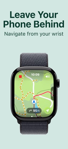
Leave your iPhone behind and navigate directly from your Apple Watch. TouchTrails provides fully offline navigation on Apple Watch, allowing you to follow routes, view essential route information, and stay on track even when your iPhone is not with you.
Measure distance and elevation:
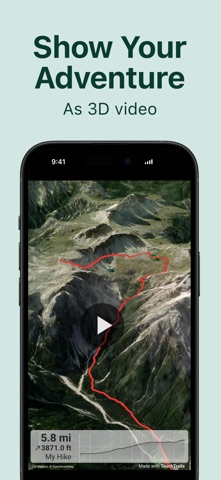
Accurate distance measurements and detailed elevation profiles help you understand how far and how high your adventure will take you.
Add and edit waypoints:
Enhance your map with highlights, tips and points of interest with waypoints. An extensive library of waypoint icons lets you customize your map.
GPS Tracker:
Record your adventures with the GPS tracker. Save, edit or share your journeys with friends.
GPX Viewer:
Found the perfect trail on the web? Import GPX files from anywhere. Navigate along the routes, measure distances and analyze elevation profiles. Edit them as you wish.
Multiple routes on one map:
Your are not limited to a single route on a map. TouchTrails allows you to view multiple routes simultaneously on one map. The flexibility of TouchTrails also allows you to combine and connect routes from different sources.
Share routes:
Send your routes to friends and share your adventure with them.
TouchTrails is the perfect route planning, GPS tracking and navigation app for all types of outdoor adventures, including:
• Running, walking and hiking
• Cycling and mountain biking
• Motorcycling
• Overlanding
• Skiing
• Mantrailing
• and many more!
TouchTrails Premium:
Upgrade to TouchTrails Premium for even more extra power!
• Snap to road
◦ TouchTrails instantly locks onto any road, bike path or hiking trail
• Turn-by-turn Navigation
◦ Voice-guided directions
◦ Off-route warnings
• Apple Watch Integration
◦ Navigate directly on your Apple Watch
◦ Fully offline – no iPhone required
• Access 100+ symbols for waypoint customization
• Save an unlimited number of routes
• Export GPX files
• Offline maps to use TouchTrails even when the internet is unavailable or unreliable
Install TouchTrails now and pave your path to unforgettable adventures!
Terms of Use: https://www.apple.com/legal/internet-services/itunes/dev/stdeula/
Safety and technology
Found in the app by AppBrain- Price
- Free
- App size
- 177.8 MB
- Content rating
- Everyone
Technologies used by Plot Routes – TouchTrails
Releases
Updates seen on the App Store- Version
- 2.23.2
- Launched
- September 2025
No changelog data
Alternatives
Similar apps and more from Wolfgang KnechtMore from Wolfgang Knecht

Rankings
App Store top chartsApp Store Rankings for Plot Routes – TouchTrails
About the app and developer
About Plot Routes – TouchTrails
Plot Routes – TouchTrails is a navigation app developed by Wolfgang Knecht.
User Ratings
Plot Routes – TouchTrails is rated 5.00 out of 5 stars. The rating is based on one rating ratings.
App Information
Plot Routes – TouchTrails is freely available from the App Store. The app size is 177.81 MB. The latest version available is 2.23.2. The last update was on October 26, 2026.
Technical Requirements
The app has a content rating of Everyone. The app has been available on the App Store since September 2025.
Developer information for Wolfgang Knecht
Address:
Frequently asked questions about Plot Routes – TouchTrails
Is Plot Routes – TouchTrails free?
Yes. Plot Routes – TouchTrails is free on the App Store.
Is Plot Routes – TouchTrails still available?
Yes. Plot Routes – TouchTrails is on the App Store, and the last update we saw was on October 26, 2026.
How large is Plot Routes – TouchTrails?
Plot Routes – TouchTrails is 177.81 MB.
Is Plot Routes – TouchTrails suitable for children?
App Store rates the content of Plot Routes – TouchTrails as suitable for everyone.
How do people rate Plot Routes – TouchTrails?
Plot Routes – TouchTrails has one rating of 5.00 stars on the App Store.
Who made Plot Routes – TouchTrails?
Plot Routes – TouchTrails was developed by Wolfgang Knecht. It is listed in the navigation category on the App Store.