

RainAware is made and published by RainAware LLC. AppBrain is an independent app data site and isn't affiliated with RainAware LLC. The app name, icon, screenshots and description belong to RainAware LLC and are shown as published on the App Store.
AppBrain's verdict
EstablishedTop 10- Best rank
- #7
- Top Paid, United States
- Rating on App Store
- 3.92
- 1,068 ratings
- Last updated
- September 28, 2026
Users are divided: 3.9 stars from 1,068 ratings. Its best ranking is #7 in Top Paid, Weather in United States.
Rankings
App Store top charts- Highest rank
- #7
- Chart
- Top Paid
- Weather
- Country
- United States
App Store Rankings for RainAware
Top rankings
| Rank | Country | Category | List |
|---|---|---|---|
| 7 | United States | Weather | Top Paid |
| 8 | Iran | Weather | Top Paid |
Ranking history in United States
Competitors
Similar apps and more from RainAware LLCAlternatives to RainAware






Releases
Updates seen on the App Store- Version
- 2.1.8
- Launched
- February 2012
No changelog data
User feedback
Ratings and reviews on the App StoreComments on RainAware for iOS
We don't have enough comments to show example comments. Please check back later.
Technology
Found in the app by AppBrain- Price
- $4.99
- App size
- 43.0 MB
- Content rating
- Everyone
Technologies used by RainAware
About the app and developer
About RainAware
RainAware is a weather app developed by RainAware LLC.
User Ratings
RainAware is rated 3.92 out of 5 stars. The rating is based on 1.1 thousand ratings.
App Information
RainAware costs $4.99. The app size is 43.02 MB. The latest version available is 2.1.8. The last update was on September 28, 2026.
Technical Requirements
The app has a content rating of Everyone. The app has been available on the App Store since February 2012.
Developer information for RainAware LLC
Address:
Store listing
By RainAware LLC, from the App Store





Description by RainAware LLC Written by the developer, not by AppBrain. Click to read.
***** INCLUDED IN THE STANDARD VERSION *****
• Rain Clock
See rain timing for your location up to 3 hours ahead.
Example: “Rain starts in 1 hr 30 min and ends at 4:30 PM.”
Background images match the weather outside.
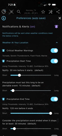
• Alerts & notifications
Get notified when rain is coming or ending, or when severe weather threatens.
Customize alert timing, rain-duration thresholds, proximity settings, and alert frequency.
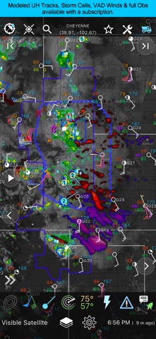
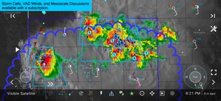
• Regional radar, satellite, and 1-hour precipitation
View live weather imagery over a regional domain, then move the domain anywhere to inspect weather there.
• Watches, warnings, and advisories
View active hazards including severe storms, floods, winter weather, wind, fire, marine alerts, and more.
• Weather map overlays
Analyze the map with overlays for surface observations, lightning, hurricane tracks, storm reports, moving ship observations, and more.
• Landscape mode & fast looping
Use landscape mode for a larger map with extra pan and zoom controls. Long-press to burst-loop imagery faster and spot trends.
• Current conditions ticker
Cycles through the nearest surface observation and also shows nearby lightning, precipitation, and storm reports when relevant. Tap icons to jump to the location.
• Interactive graphs
View 36-hour trend graphs for temperature, wind, cloud cover, precipitation amount and type.
• Forecast Clock
See the next 8 days in a concise Today/Tonight format, including sunrise, sunset, and moon phase.
• Site lists
Quickly check weather for nearby cities, airports, ballparks, speedways, golf courses, and more. Stadium views include wind direction for in, out, or across-field awareness.
• Drawing tools
Draw on the map, add text, overlay it on weather imagery, and share.
• Weather badges
Badges show when rapid changes in rain, temperature, clouds, or wind are forecast. Configurable.
• Deep customization
RainAware includes extensive settings so you can tune the app to your workflow.
***** SUBSCRIPTION FEATURES *****
Subscriptions are available in-app and work across supported devices.
• Full-map access
View the full weather map without regional limits.
• Storm cell tracking
Filter storm cells and view motion, hail potential, rotation, and more.
• National radar products
Includes Echo Tops, Hail Swaths, and Rotation Tracks.
• Single-site radar
Access reflectivity and velocity products, with options to merge Hawaii, Alaska, and Puerto Rico radar into the national view.
• Expanded satellite imagery
Adds water vapor and colorized visible imagery for enhanced cloud-top analysis.
• More alert types
Add lightning proximity alerts, severe storm report alerts, and alerts for another location.
• RainPro tool
Interactively refine precipitation motion for even more precise rain timing.
• Environmental fields
Display threat areas, VAD wind profiles, isobars, CAPE, updraft helicity, 500 & 850 mb charts & more.
• Warning & observation monitor
Filter and sort warnings and surface observations.
• Advanced surface observations
Plot thousands of stations, ships, and buoys, including water temperature and wave height.
• Longer loops
Animate up to 36 frames and as much as 12 hours ahead on capable devices.
• Aviation mode
Use FAA sectional maps as an underlay, display flight rules at stations, and view winds aloft at VWP locations.
• Advanced drawing tools
Draw fronts, time-match drawings to imagery, and create lines, polygons, circles, and squares.
• Faster data updates
Get more frequent radar, satellite, and surface data refreshes.
• Performance controls
Manage memory, cache behavior, panning, and image tiling.
Coverage is best across the USA and southern Canada. Satellite and local radar coverage also extends from Hawaii to the Caribbean. https://www.rainaware.com/rainaware_coverage_map.webp