

Rome Subway Map
Rome Subway Map is made and published by Yaroslav Mykolaienko. AppBrain is an independent app data site and isn't affiliated with Yaroslav Mykolaienko. The app name, icon, screenshots and description belong to Yaroslav Mykolaienko and are shown as published on the App Store.
AppBrain's verdict
- Last updated
- September 3, 2026
- Size
- 45.9 MB
User feedback
Ratings and reviews on the App StoreComments on Rome Subway Map for iOS
We don't have enough comments to show example comments. Please check back later.
Store listing
By Yaroslav Mykolaienko, from the App Store

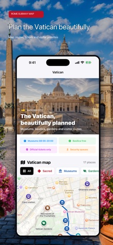


Description by Yaroslav Mykolaienko Written by the developer, not by AppBrain. Click to read.
Rome Subway Map & Transit brings the city's transport network, route planning and essential visitor tools together in one clear travel companion. Whether you are crossing the historic center, changing lines at Termini, reaching the Vatican or arriving from the airport, the information you need is only a few taps away.
EXPLORE THE ROME TRANSPORT NETWORK
See Rome's Metro lines on a detailed geographic map, then explore rail, tram, trolleybus and bus services without losing your sense of place. Switch between transport types, focus on a selected route and view its stations directly on the city map.
The network is organized into practical groups, including:
- Metro lines A, B, B1 and C
- Urban and regional rail connections
- Tram and trolleybus routes
- Local, express and variant bus services
- Night transport
- Airport connections
- Suburban services
- On-demand transport where available
PLAN A ROUTE THAT MAKES SENSE
Choose an origin and destination, select the transport types you want to use and compare a route in a format that is easy to follow. Each result separates the journey into clear stages, with line changes, walking connections, estimated journey details and fare guidance.
When both endpoints are Metro stations, the planner prioritizes a Metro journey, helping you avoid unnecessary bus detours. You can also start or finish a route directly from a station card.
UNDERSTAND EVERY STATION
Open a station or stop to see more than a name on a map. Station cards bring together:
- Available lines and transport modes
- Useful interchange options
- From Here and To Here route actions
- Nearby attractions and significant places
- Distance context for local landmarks
- Relevant tours and ticket options
DISCOVER THE VATICAN WITH CONFIDENCE
Use a dedicated Vatican experience with its own map and carefully organized visitor information. Explore St. Peter's Basilica, the Vatican Museums, Sistine Chapel, Vatican Gardens, the dome, grottoes, necropolis sites and other important places.
Review practical visit priorities, typical time requirements, ticket guidance and opening-hour information before building your day. Browse Vatican-focused tours and experiences when you want additional help or reserved entry.
GET FROM THE AIRPORT TO ROME
Compare the main ways to reach the city from Fiumicino (FCO) and Ciampino (CIA). Find guidance for Leonardo Express, FL1 rail connections, airport buses and useful transfer points, with clear links back into the wider Rome network.
MAKE MORE OF EVERY DAY
Rome Subway Map & Transit is also designed for the moments between journeys:
- Current weather overview and a seven-day outlook
- A station-based Rome sightseeing guide
- Attractions, museums and significant places
- Shopping streets and local market guidance
- VAT and tax-free shopping tools
- Fare and ticket information
- Travel safety and practical city information
- Tours and experiences for Rome and Vatican City
DESIGNED FOR TRAVEL
The interface is built for quick decisions on iPhone and the extra space of iPad. Color-coded routes, recognizable transport icons, searchable content and map-based navigation help you understand where you are and what to do next.
Download Rome Subway Map & Transit and spend less time untangling the network - and more time experiencing Rome.
Transport schedules, fares, opening hours and visitor conditions can change. Always confirm time-sensitive information with the relevant official operator or venue before travel.
Safety and technology
Found in the app by AppBrain- Price
- Free
- App size
- 45.9 MB
- Content rating
- Everyone
Technologies used by Rome Subway Map
Releases
Updates seen on the App Store- Version
- 4.0
- Launched
- January 2024
No changelog data
Alternatives
Similar apps and more from Yaroslav MykolaienkoAlternatives to Rome Subway Map


More from Yaroslav Mykolaienko





Rankings
App Store top chartsApp Store Rankings for Rome Subway Map
About the app and developer
About Rome Subway Map
Rome Subway Map is a navigation app developed by Yaroslav Mykolaienko.
User Ratings
The app has no ratings yet.
App Information
Rome Subway Map is freely available from the App Store. The app size is 45.92 MB. The latest version available is 4.0. The last update was on September 3, 2026.
Technical Requirements
The app has a content rating of Everyone. The app has been available on the App Store since January 2024.
Developer information for Yaroslav Mykolaienko
Address: