

San Francisco Subway map
San Francisco Subway map is made and published by Yaroslav Mykolaienko. AppBrain is an independent app data site and isn't affiliated with Yaroslav Mykolaienko. The app name, icon, screenshots and description belong to Yaroslav Mykolaienko and are shown as published on the App Store.
AppBrain's verdict
- Last updated
- October 14, 2026
Rankings
App Store top chartsApp Store Rankings for San Francisco Subway map
Competitors
Similar apps and more from Yaroslav MykolaienkoAlternatives to San Francisco Subway map


More from Yaroslav Mykolaienko




Releases
Updates seen on the App Store- Version
- 3.0
- Launched
- January 2024
No changelog data
User feedback
Ratings and reviews on the App StoreComments on San Francisco Subway map for iOS
We don't have enough comments to show example comments. Please check back later.
Technology
Found in the app by AppBrain- Price
- Free
- App size
- 22.1 MB
- Content rating
- Everyone
Technologies used by San Francisco Subway map
About the app and developer
About San Francisco Subway map
San Francisco Subway map is a navigation app developed by Yaroslav Mykolaienko.
User Ratings
The app has no ratings yet.
App Information
San Francisco Subway map is freely available from the App Store. The app size is 22.10 MB. The latest version available is 3.0. The last update was on October 14, 2026.
Technical Requirements
The app has a content rating of Everyone. The app has been available on the App Store since January 2024.
Developer information for Yaroslav Mykolaienko
Address:
Store listing
By Yaroslav Mykolaienko, from the App Store



Description by Yaroslav Mykolaienko Written by the developer, not by AppBrain. Click to read.
From an airport arrival to a waterfront afternoon or your daily commute, San Francisco Subway Map helps you connect the journey with the destination. Keep transport information, sightseeing ideas and useful travel tools together on your iPhone or iPad.
YOUR BAY AREA TRANSIT MAP
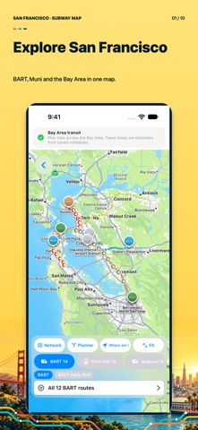
See routes and stops on an interactive map. Browse BART and Muni Metro alongside cable cars, historic streetcars, local and regional buses, commuter rail and ferries. The bundled transport network contains 147 routes and 5,198 stops drawn from seven official data sources. Explore San Francisco, the Peninsula and the East Bay with one consistent view of the network.
PLAN A ROUTE BEFORE YOU GO
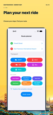
Choose your starting point and destination, select the transport categories you want to use and review the trip. See the route's legs, stops, transfers, walking connections and estimated travel time. Follow the journey on the map and understand where to change. Use the planner for a familiar commute, an unfamiliar station or a day of sightseeing across the bay.
OFFLINE ESSENTIALS, ONLINE MAPS
The bundled transit network, route calculations and rail map are available without an internet connection. Keep the essentials close when mobile reception is limited or you are traveling without roaming. Interactive map imagery, external websites and online travel services need a connection. Travel estimates are based on static network data and do not guarantee current departures or live service conditions.
DISCOVER MORE AROUND EACH STOP
Pair your transport plan with a city guide. Browse station information, nearby attractions, neighborhood highlights and practical suggestions for the next part of your day. Explore downtown, the waterfront, Golden Gate Park, Chinatown, the Castro and destinations beyond the city center. Find inspiration for a short visit or use the guide to build a fuller Bay Area itinerary.
MAKE THE MOST OF YOUR VISIT
• Discover photo spots, waterfront walks and architecture.
• Explore suggested visit plans for one to seven days.
• Listen to spoken guide content using the audio guide.
• Check San Francisco sunrise and sunset times for a selected date.
• Open places in Maps to continue your journey.
• Keep useful addresses together for later reference.
AIRPORTS AND PRACTICAL TRAVEL
Find guidance for SFO, OAK and SJC, with airport information and transport context to help prepare your arrival or departure. Read fare and payment references, review transfer information and open official sources for details. Travel sections provide access to hotels, flights, tours, car rentals and mobile data options through external providers. Their availability and terms depend on the provider.
HELPFUL INFORMATION WITHIN REACH
Access emergency and non-emergency contact information, city services and practical visitor tips. Organize your plans before leaving the hotel, compare the transport options that suit your day and keep the next stop in view. The app is useful for visitors, commuters and students who want to understand how San Francisco and the Bay Area fit together.
San Francisco Subway Map is an independent travel companion and is not affiliated with BART, SFMTA or other transport operators. Always confirm current service, fares, opening hours and airport information with official sources. A translated App Store description does not mean every app screen or external service supports that language.
Start with a downtown station, look at the connections towards the waterfront or explore a cross-bay trip. The map, route result and place information let you prepare each part of the day before setting out.
Open the map. Plan your journey. Discover San Francisco, one stop at a time.