

ScopX is made and published by MorrDigital. AppBrain is an independent app data site and isn't affiliated with MorrDigital. The app name, icon, screenshots and description belong to MorrDigital and are shown as published on the App Store.
AppBrain's verdict
- Last updated
- August 4, 2026
- Size
- 145.5 MB
User feedback
Ratings and reviews on the App StoreComments on ScopX for iOS
We don't have enough comments to show example comments. Please check back later.
Store listing
By MorrDigital, from the App Store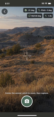




Screenshots by MorrDigital, from the the App Store listing
Description by MorrDigital Written by the developer, not by AppBrain. Click to read.
ScopX is a hunting GPS, field-mapping, and stalk-planning app built for spot-and-stalk hunters. Scout terrain, locate targets, evaluate visibility and wind, and plan an approach using one connected mobile toolkit.
Whether you are pursuing elk, deer, turkey, antelope, bear, coyote, or other game, ScopX helps you understand the terrain between you and your target before you move.
HUNTING MAPS AND FIELD TOOLS
• Interactive satellite, topographic, terrain, water, and available land-feature layers
• Switch between live GPS and a manual scouting location for planning future hunts
• Search for an address or place, enter coordinates, or select locations directly on the map
• Download selected map layers and elevation data for offline use
• View current location, elevation, wind, temperature, and precipitation information
• Explore supported terrain and saved map content in 2D or 3D
ACQUIRE AND SAVE TARGETS
Use your phone’s camera, compass, GPS, and motion sensors to estimate and save an animal’s location.
• Capture a target image with bearing, pitch, roll, zoom, and location information
• Enter a known rangefinder distance
• Estimate distance using animal size and photo scale with Pro
• Estimate a terrain intersection along the sight line with Pro
• Compare available estimates and select the best target location
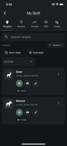
• Save notes, photos, animal type, and location information for later use
ANIMAL SIGHT ZONES
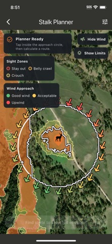
ScopX Pro uses elevation data and terrain analysis to estimate where an animal may be able to see a standing, crouching, or crawling hunter.
Display color-coded sight zones on the map to identify exposed terrain, possible blind spots, and lower-visibility approaches. Viewsheds can be displayed in supported 2D and 3D map views.
STALK PLANNER
Build a terrain-aware route from your current or manual scouting location toward a selected target.
The ScopX Pro Stalk Planner evaluates:
• Animal sight zones
• Wind direction and approach angle
• Terrain slope and elevation
• Walking, crouching, and crawling preferences
• Mapped water
• Avoid and blocked areas
• Distance and movement cost
Choose an approach point, adjust your preferences, review route limits, and save the resulting stalk route to your map.
WIND AND SCENT
Use current or manually selected wind direction to understand your approach. Pro wind tools include a scent cone and wind visualization to help communicate the likely downwind direction from your position.
ROUTES, TRACKS, MARKERS, AND AREAS
• Drop animal targets and custom points of interest
• Save tree stands, glassing points, camps, water sources, trailheads, and other locations
• Draw routes manually
• Record your movement as a GPS track
• Create saved areas with configurable route policies
• View distance, ascent, descent, elevation range, and elevation profiles
• Organize targets, routes, tracks, POIs, and areas in My Stuff
BUILT FOR FIELD USE AND AT-HOME SCOUTING
ScopX supports both live field navigation and manual scouting from another location. Prepare offline maps before leaving service, evaluate terrain around saved targets, and plan possible approaches before the hunt.
PRO FEATURES
A ScopX Pro subscription unlocks:
• Terrain-aware Stalk Planner
• Animal sight-zone and viewshed analysis
• Photo-scale distance estimation
• Terrain-intersection target estimation
• Wind and scent visualization
• 3D terrain maps
ScopX calculations depend on available terrain data, weather services, device sensors, GPS accuracy, and user-entered information. Always verify field conditions and use appropriate navigation and safety practices.
Scout smarter. Understand the terrain. Plan your approach with ScopX.
Privacy Policy: https://scopx.app/privacy.html
Terms of Use (EULA): hthttps://scopx.app/terms.html
Whether you are pursuing elk, deer, turkey, antelope, bear, coyote, or other game, ScopX helps you understand the terrain between you and your target before you move.
HUNTING MAPS AND FIELD TOOLS
• Interactive satellite, topographic, terrain, water, and available land-feature layers
• Switch between live GPS and a manual scouting location for planning future hunts
• Search for an address or place, enter coordinates, or select locations directly on the map
• Download selected map layers and elevation data for offline use
• View current location, elevation, wind, temperature, and precipitation information
• Explore supported terrain and saved map content in 2D or 3D
ACQUIRE AND SAVE TARGETS
Use your phone’s camera, compass, GPS, and motion sensors to estimate and save an animal’s location.
• Capture a target image with bearing, pitch, roll, zoom, and location information
• Enter a known rangefinder distance
• Estimate distance using animal size and photo scale with Pro
• Estimate a terrain intersection along the sight line with Pro
• Compare available estimates and select the best target location
• Save notes, photos, animal type, and location information for later use
ANIMAL SIGHT ZONES
ScopX Pro uses elevation data and terrain analysis to estimate where an animal may be able to see a standing, crouching, or crawling hunter.
Display color-coded sight zones on the map to identify exposed terrain, possible blind spots, and lower-visibility approaches. Viewsheds can be displayed in supported 2D and 3D map views.
STALK PLANNER
Build a terrain-aware route from your current or manual scouting location toward a selected target.
The ScopX Pro Stalk Planner evaluates:
• Animal sight zones
• Wind direction and approach angle
• Terrain slope and elevation
• Walking, crouching, and crawling preferences
• Mapped water
• Avoid and blocked areas
• Distance and movement cost
Choose an approach point, adjust your preferences, review route limits, and save the resulting stalk route to your map.
WIND AND SCENT
Use current or manually selected wind direction to understand your approach. Pro wind tools include a scent cone and wind visualization to help communicate the likely downwind direction from your position.
ROUTES, TRACKS, MARKERS, AND AREAS
• Drop animal targets and custom points of interest
• Save tree stands, glassing points, camps, water sources, trailheads, and other locations
• Draw routes manually
• Record your movement as a GPS track
• Create saved areas with configurable route policies
• View distance, ascent, descent, elevation range, and elevation profiles
• Organize targets, routes, tracks, POIs, and areas in My Stuff
BUILT FOR FIELD USE AND AT-HOME SCOUTING
ScopX supports both live field navigation and manual scouting from another location. Prepare offline maps before leaving service, evaluate terrain around saved targets, and plan possible approaches before the hunt.
PRO FEATURES
A ScopX Pro subscription unlocks:
• Terrain-aware Stalk Planner
• Animal sight-zone and viewshed analysis
• Photo-scale distance estimation
• Terrain-intersection target estimation
• Wind and scent visualization
• 3D terrain maps
ScopX calculations depend on available terrain data, weather services, device sensors, GPS accuracy, and user-entered information. Always verify field conditions and use appropriate navigation and safety practices.
Scout smarter. Understand the terrain. Plan your approach with ScopX.
Privacy Policy: https://scopx.app/privacy.html
Terms of Use (EULA): hthttps://scopx.app/terms.html
Safety and technology
Found in the app by AppBrain- Price
- Free
- App size
- 145.5 MB
- Content rating
- Everyone
Technologies used by ScopX
Releases
Updates seen on the App Store- Version
- 1.1
- Launched
- November 2025
No changelog data
Alternatives
Similar apps and more from MorrDigitalAlternatives to ScopX


Also available on Google Play

Rankings
App Store top chartsApp Store Rankings for ScopX
This app is not ranked
About the app and developer
About ScopX
ScopX is a sports app developed by MorrDigital.
What is the rating of ScopX?
ScopX has no ratings yet.
Is ScopX free?
ScopX is free. The app size is 145.54 MB. The latest version available is 1.1. The last update was on August 4, 2026.
What are the requirements for ScopX?
The app has a content rating of Everyone. The app has been available on the App Store since November 2025.
Developer information for MorrDigital
Address: