SeaVectors: Marine Navigation is a navigation app developed by SMALL TECHNOLOGIES INC..
User Ratings
The app has no ratings yet.
App Information
SeaVectors: Marine Navigation is FREE to download. The download size is 80.46 MB. The latest version available is 2.8.1. The last update was on October 2, 2026.
Technical Requirements
The app has a content rating of Everyone. The app has been available on the App Store since June 2025.
Description
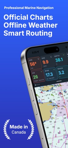
Official ENC charts. Seabed relief. Marine weather and currents. Your boat’s instruments. One app.
SeaVectors brings together official charts, regional current models, marine forecasts, tide predictions, AIS collision awareness and your boat’s NMEA data. Explore full NOAA chart coverage for the United States and high-definition vector charts for the Canada West Coast.
Try everything free for 30 days.
PROFESSIONAL ENC CHARTS Charts use official S-57 data and S-52 symbology, with day/night palettes and a boat-specific safety contour. Tap objects to read their official attributes. Choose nautical, night, satellite or relief styles and control individual layers.
SEE THE SEABED Shaded bathymetry reveals ledges, channels and drop-offs. Coverage includes British Columbia, the US West Coast, Puget Sound, Florida and the US East Coast, with detail down to 1 metre in selected areas.
EXPLORE AND SAVE The crosshair identifies charted wrecks, rocks, obstructions, bridge clearances, lights, buoys, depths and bottom types. Charts cache as you browse. Download charts and relief for selected areas before departure, and manage saved data in Storage Management.
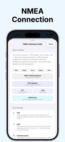
CONNECT TO YOUR BOAT Connect over Wi-Fi to your NMEA 0183 or NMEA 2000 network for live speed, depth, wind, heading, position, RPM, fuel and more. Monitor multiple engines, tanks and batteries, and build your own instrument dashboard.
AIS COLLISION AWARENESS See nearby vessels with closest point of approach (CPA) and time to CPA (TCPA). Custom thresholds, colour-coded risk and escalating alarms help identify developing collision risks.
TIDES AND REGIONAL CURRENTS View CHS and NOAA station predictions for tide heights, highs and lows, current speed and direction, flood, ebb and slack. Animated currents use Canadian ECCC CIOPS models and NOAA regional models covering the Pacific and Atlantic coasts, Gulf of Mexico and Great Lakes, plus broader RTOFS East coverage. Nearby station predictions refine local currents where applicable, with Open-Meteo as a fallback. Smooth particles, speed-based colours and legends make flow easier to follow.
WEATHER ON ONE TIMELINE Compare wind, gusts, waves, tides and currents in a redesigned panel with coloured curves and animated map overlays. Sources include NOAA NWS, Environment and Climate Change Canada, GEM, NOAA GFS, ECMWF IFS, ECMWF AIFS and Météo-France. Auto and Open-Meteo Best Match simplify selection. Open-Meteo marine forecasts and NOAA GFS-Wave add marine coverage. Open at NOW, keep the selected hour when switching tabs, and return to current conditions with one tap. Save available forecasts for offline access. Coverage and forecast length vary by location, source and time.
PLAN AND RECORD Create routes with distance, ETA and fuel estimates, and preview them with simulation. Record and replay tracks. Save markers with notes, photos or video. Receive alerts for charted Restricted Areas and supported DFO fishing closures.
YOUR UNITS, YOUR LANGUAGE Choose feet or metres, °F or °C, and knots, mph or km/h. Available in English and Simplified Chinese. SeaVectors aids navigation. It does not replace official paper charts, a proper lookout or prudent seamanship. Always cross-check.
SUBSCRIPTION Includes a 30-day free trial. A subscription is required afterward for continued full access. Payment is charged to your Apple ID and renews automatically unless cancelled at least 24 hours before the current period ends. Manage or cancel in your App Store account settings.
Apple Terms of Use (EULA) https://www.apple.com/legal/internet-services/itunes/dev/stdeula/
Each subscription will automatically renew 3 days before the expiration date for
the same time period. Subscriptions can be cancelled at any time before the renewal.