

ShadeWalk – Shady Route Map
ShadeWalk – Shady Route Map is made and published by MyeongJin Lee. AppBrain is an independent app data site and isn't affiliated with MyeongJin Lee. The app name, icon, screenshots and description belong to MyeongJin Lee and are shown as published on the App Store.
AppBrain's verdict
- Last updated
- September 28, 2026
Rankings
App Store top chartsApp Store Rankings for ShadeWalk – Shady Route Map
Competitors
Similar apps and more from MyeongJin LeeMore from MyeongJin Lee


Releases
Updates seen on the App Store- Version
- 1.3.0
- Launched
- July 2026
No changelog data
User feedback
Ratings and reviews on the App StoreComments on ShadeWalk – Shady Route Map for iOS
We don't have enough comments to show example comments. Please check back later.
Technology
Found in the app by AppBrain- Price
- Free
- App size
- 105.4 MB
- Content rating
- Everyone
Technologies used by ShadeWalk – Shady Route Map
About the app and developer
About ShadeWalk – Shady Route Map
ShadeWalk – Shady Route Map is a navigation app developed by MyeongJin Lee.
User Ratings
The app has no ratings yet.
App Information
ShadeWalk – Shady Route Map is freely available from the App Store. The app size is 105.42 MB. The latest version available is 1.3.0. The last update was on September 28, 2026.
Technical Requirements
The app has a content rating of Everyone. The app has been available on the App Store since July 2026.
Developer information for MyeongJin Lee
Address:
Frequently asked questions about ShadeWalk – Shady Route Map
Is ShadeWalk – Shady Route Map free?
Yes. ShadeWalk – Shady Route Map is free on the App Store.
Is ShadeWalk – Shady Route Map still available?
Yes. ShadeWalk – Shady Route Map is on the App Store, and the last update we saw was on September 28, 2026.
How large is ShadeWalk – Shady Route Map?
ShadeWalk – Shady Route Map is 105.42 MB.
Is ShadeWalk – Shady Route Map suitable for children?
App Store rates the content of ShadeWalk – Shady Route Map as suitable for everyone.
Who made ShadeWalk – Shady Route Map?
ShadeWalk – Shady Route Map was developed by MyeongJin Lee. It is listed in the navigation category on the App Store.
Store listing
By MyeongJin Lee, from the App Store



Description by MyeongJin Lee Written by the developer, not by AppBrain. Click to read.
ShadeWalk turns building shadows and the sun's position into shadier walking routes, then keeps your steps and walk history together.
● Compare minutes in the sun
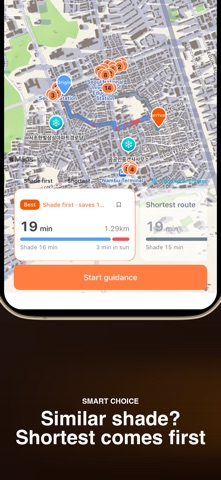
Set a start and destination to compare shade-first, shortest, and balanced routes. Route cards show sun exposure and detour time, while the map marks nearby heat shelters. The time slider previews how shadows move through the day.
● ShadeWalk for your travels
Tokyo, Bangkok, Paris, New York, Dubai, Sydney. Find shaded walking routes in the cities you explore on foot. Coverage today is nationwide South Korea plus about 340 cities in 78 countries and territories. East Asia: Japan, Taiwan, Hong Kong, Macau, Mongolia. Southeast Asia: Vietnam, Thailand, Malaysia, Singapore, Indonesia, the Philippines, Laos, Cambodia, Myanmar. South Asia: India, Sri Lanka, Nepal. Middle East and Central Asia: the United Arab Emirates, Qatar, Oman, Israel, Türkiye, Georgia, Azerbaijan, Kazakhstan, Uzbekistan. Africa: Egypt, Morocco, Tunisia, South Africa, Kenya, Tanzania. Europe: the United Kingdom, France, Spain, Italy, Germany, the Netherlands, Belgium, Luxembourg, Switzerland, Austria, Czechia, Slovakia, Poland, Hungary, Slovenia, Croatia, Greece, Portugal, Ireland, Denmark, Norway, Sweden, Finland, Iceland, Estonia, Latvia, Lithuania. North and Central America: the United States, Canada, Mexico, Cuba, Panama, Costa Rica. South America: Brazil, Argentina, Chile, Peru, Colombia, Ecuador, Uruguay. Oceania: Australia, New Zealand, Fiji, Guam, Saipan. When reliable shadow data is unavailable, ShadeWalk says so instead of guessing.
● Search places, stations, and exits
Search a place, station, landmark, or exit, then check its pin and distance before planning. Zoom in for station exit numbers and search phrases such as “Gangnam Station Exit 7” or “Hakata Nishi 4.”
● Save, search, and share frequent routes
Keep routes you created and routes shared with you in separate library sections. Search them by name, share a link, and save a received route only after reviewing it. Shade is recalculated for the time you walk.
● Steps and walk history
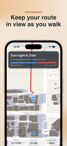
Review today's steps, distance, time, calories, and weekly activity. Walk records can sync with Apple Health. During guidance, progress stays visible on the Lock Screen and Dynamic Island on supported devices.
● UV and heat context
In South Korea, destination-based UV, heat-wave, and tropical-night information appears when complete data is available. Missing or partial server data stays hidden.
● Honest shadow estimates
Shadows are estimates based on registered building heights and floors, street trees where available, the sun's position, and the selected time. Missing data and estimated heights are clearly marked. Shade scoring and original walk records are processed on-device. To improve the app, we collect non-sensitive usage statistics; precise location, search content, walk records, and health data are never sent. Map, search, route, air-quality, and weather requests may send related coordinates to Apple, Google, or Kakao.
Find shade, save the walk, and take it again tomorrow.
Contact: dlaudwls1203@gmail.com