

Skyty: Offline Flight Tracker
Skyty: Offline Flight Tracker is made and published by Kim Engels. AppBrain is an independent app data site and isn't affiliated with Kim Engels. The app name, icon, screenshots and description belong to Kim Engels and are shown as published on the App Store.
AppBrain's verdict
- Last updated
- May 19, 2026
- Size
- 144.4 MB
User feedback
Ratings and reviews on the App StoreComments on Skyty: Offline Flight Tracker for iOS
We don't have enough comments to show example comments. Please check back later.
Store listing
By Kim Engels, from the App Store




Description by Kim Engels Written by the developer, not by AppBrain. Click to read.
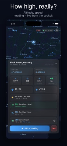
Skyty turns your iPhone into a personal flight instrument. Live GPS position, altitude above ground (AGL), speed, heading, and a beautiful offline map — all in airplane mode.
WHY PASSENGERS & PILOTS LOVE SKYTY
• 100% offline. GPS works without WiFi or cellular.
• 47,000+ airports worldwide (IATA + ICAO)
• True altitude above ground using NASA terrain data
• One-time purchase. No tracking. No ads. No accounts.
BUILT FOR THE WINDOW SEAT
Ever wondered "what am I flying over?" Skyty tells you — in real time, without paying for in-flight WiFi. Cities, mountains, coastlines, and the nearest airport, always on screen.
PRECISE FLIGHT DATA
• Live position, speed, heading and GPS accuracy
• Altitude in GPS (WGS84) or MSL (mean sea level)
• Altitude above ground (AGL) powered by SRTM terrain
• Next airport with distance and bearing
• Destination airport with ETA
FOR PILOTS & GLIDER PILOTS
• Flight recording with distance, duration, max altitude, avg speed
• GPX export to your favorite flight log
• Runway prediction — active runway highlighted on map
• HD terrain data (~900m grid) for precise AGL
• Not certified avionics — optimized as a passenger companion with pilot features
APPLE WATCH & WIDGETS
• Companion app for Apple Watch
• Home Screen widgets for live position
• Live Activity during flight
4 MAP THEMES
Aviation Dark (cockpit-optimized), Aviation Light, Satellite, Topographic.
PRIVACY FIRST
Skyty processes GPS data exclusively on your device. No cloud. No tracking. No analytics. No accounts. Your flight history stays local.
FREE
• Live position & speed
• GPS altitude
• Basic offline map
PREMIUM — ONE-TIME PURCHASE
• Everything in Free
• Altitude above ground (AGL)
• HD terrain data
• Flight recording & GPX export
• Altitude profile chart
• HD world map (Zoom 0–10)
• All map themes
• Sun position indicator with seat recommendation
No subscription. No renewal. Works fully offline.
DATA SOURCES
OpenStreetMap (ODbL) · Protomaps (BSD/CC0) · MapLibre Native (BSD-3) · OurAirports (Public Domain) · NASA SRTM (Public Domain) · Natural Earth (Public Domain)
Made with GPS data and window seats in Zürich.
Safety and technology
Found in the app by AppBrain- Price
- Free
- App size
- 144.4 MB
- Content rating
- Everyone
Technologies used by Skyty: Offline Flight Tracker
Releases
Updates seen on the App Store- Version
- 1.5
- Launched
- April 2026
No changelog data
Alternatives
Similar apps and more from Kim EngelsMore from Kim Engels

Rankings
App Store top charts- Highest rank
- #58
- Chart
- Top Grossing
- Travel
- Country
- Portugal
About the app and developer
About Skyty: Offline Flight Tracker
Skyty: Offline Flight Tracker is a travel app developed by Kim Engels.
User Ratings
The app has no ratings yet.
App Information
Skyty: Offline Flight Tracker is freely available from the App Store. The app size is 144.37 MB. The latest version available is 1.5. The last update was on May 19, 2026.
Technical Requirements
The app has a content rating of Everyone. The app has been available on the App Store since April 2026.
Developer information for Kim Engels
Address: