

Survival Pro
Survival Pro is made and published by Mikolaj Adamowicz. AppBrain is an independent app data site and isn't affiliated with Mikolaj Adamowicz. The app name, icon, screenshots and description belong to Mikolaj Adamowicz and are shown as published on the App Store.
AppBrain's verdict
- Last updated
- May 18, 2026
Rankings
App Store top chartsApp Store Rankings for Survival Pro
Competitors
Similar apps and more from Mikolaj AdamowiczAlternatives to Survival Pro


More from Mikolaj Adamowicz








Releases
Updates seen on the App Store- Version
- 1.0.0
- Launched
- May 2026
No changelog data
User feedback
Ratings and reviews on the App StoreComments on Survival Pro for iOS
We don't have enough comments to show example comments. Please check back later.
Technology
Found in the app by AppBrain- Price
- $2.99
- App size
- 7.81 MB
- Content rating
- Everyone
Technologies used by Survival Pro
About the app and developer
About Survival Pro
Survival Pro is an utilities app developed by Mikolaj Adamowicz.
What is the rating of Survival Pro?
Survival Pro has no ratings yet.
Is Survival Pro free?
Survival Pro costs $2.99. The app size is 7.81 MB. The latest version available is 1.0.0. The last update was on May 18, 2026.
What are the requirements for Survival Pro?
The app has a content rating of Everyone. The app has been available on the App Store since May 2026.
Developer information for Mikolaj Adamowicz
Address:
Store listing
By Mikolaj Adamowicz, from the App Store




Description by Mikolaj Adamowicz Written by the developer, not by AppBrain. Click to read.
Key Features
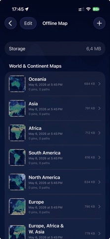
• Offline Maps: Download regions for reliable navigation without a network. Pan, zoom, and plan routes anywhere.
• Trail Tracking: Start, pause, resume, and stop trails with distance, elevation, and pace at a glance.
• Emergency Card: Store medical info and emergency contacts for quick access in critical moments.
• Offline Notes: Capture notes and waypoints without connectivity and review them anytime.
• Live Sensors: Monitor altitude, motion, battery, torch, audio levels, and more for situational awareness.
• Morse Signaling: Broadcast Morse code via light or sound, and decode received Morse to text for simple off‑grid communication.
• GPS in Flight/Cruise: View your GPS position even in flight or during a cruise to stay oriented when data services are limited.
• Language Support: Interface and content adapt to your selected language with dynamic translation updates.
• Capability Awareness: See which features are supported in your current environment.
LiDAR Tools
• LiDAR Motion Alarm: Use the device’s depth sensor to detect movement in a defined zone. Receive audible/visual alerts—useful for camp perimeters, gear monitoring, or basic intrusion awareness in low‑light conditions.
• LiDAR Night Vision: Enhance visibility in darkness using depth‑assisted rendering. Visualize shapes and distances with a high‑contrast depth view to navigate or scan surroundings when ambient light is limited.
How It Works
1. Set Language: Choose your preferred language; the UI updates automatically.
2. Prepare Offline Maps: Download map regions before you head out for full offline access.
3. Create Emergency Card: Add medical conditions, allergies, medications, and contacts.
4. Track Trails: Record distance and elevation; pause/stop anytime and review history later.
5. Monitor Sensors: Check altitude, motion, torch, audio levels, battery, and more.
6. Morse Broadcast & Decode: Send light/sound Morse messages and decode received Morse into text.
7. Use LiDAR Features: Activate Motion Alarm to monitor a zone; switch to Night Vision to visualize depth in low light.
Safety Tips
• Download maps in advance.
• Keep your emergency card updated.
• Monitor battery and carry a power source for longer trips.
• Use Morse and LiDAR features responsibly and within local regulations.
• Respect airline and maritime rules when using GPS or other device features in flight or at sea.
Warning & Liability
This app is provided for informational and recreational use only. It does not replace professional guidance, certified navigation tools, or emergency services. Outdoor activities and travel involve risks, including injury, loss, or death. Always assess conditions, prepare appropriately, and follow local laws, airline, and maritime safety guidelines. The developers and distributors do not accept responsibility or liability for accidents, damages, losses, or consequences arising from use or misuse of the app, reliance on its data, Morse or LiDAR features, GPS in flight/cruise, or interruptions in service. By using the app, you accept all risks and are solely responsible for your decisions and actions. In emergencies, contact local authorities immediately.
Note on Device Capabilities
Feature availability depends on your device’s hardware and sensors. LiDAR Motion Alarm and LiDAR Night Vision require a compatible depth camera. GPS availability and accuracy may vary by location, regulations, and travel mode. Not all functions will be available on every device.