

swisschecker: Switzerland Map
swisschecker: Switzerland Map is made and published by THOMAS CHRISTIAN HAGNAUER. AppBrain is an independent app data site and isn't affiliated with THOMAS CHRISTIAN HAGNAUER. The app name, icon, screenshots and description belong to THOMAS CHRISTIAN HAGNAUER and are shown as published on the App Store.
AppBrain's verdict
- Last updated
- October 30, 2026
- Size
- 41.3 MB
User feedback
Ratings and reviews on the App StoreComments on swisschecker: Switzerland Map for iOS
We don't have enough comments to show example comments. Please check back later.
Store listing
By THOMAS CHRISTIAN HAGNAUER, from the App Store




Description by THOMAS CHRISTIAN HAGNAUER Written by the developer, not by AppBrain. Click to read.
IMPORTANT: swisschecker is a private, independent app. It does not represent any government agency and is not affiliated with the Swiss federal administration or any other public body. The data comes from publicly available sources, all listed below with links.
"From Bern to Zermatt", "Hike from Kandersteg to Oeschinensee", "How warm is the Aare?", "Temperature in Bern since 1864": swisschecker understands the question and fetches the answer live from the open data of public bodies. Nothing is made up – if a source is missing, the app tells you.
EVERY ROUTE ON THE MAP
• Hiking, cycling, driving and public transport on the national map
• Drag start, finish and stops with your finger – the route recalculates
• Walking time by the Swiss Hiking Federation's formula, with elevation profile
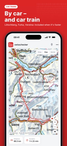
• Car routes with car trains: Lötschberg, Furka and Vereina included when they save time
• Save maps offline – for places without signal
• Fullscreen navigation with live arrival time
PUBLIC TRANSPORT IN SECONDS
• Connections with platform, changes and the way on the map
• Departures from any stop
• Cancellations and disruptions from official real-time data
• Stops with a stay on the way: Thun – Bern (2 h) – Zurich
• Straight on to fares and tickets on sbb.ch
WEATHER – YESTERDAY'S TOO
• MeteoSwiss forecasts hour by hour, mountain villages included
• Weather history: measurements back to 1864, chart zoomable to the hour
• Rain, sun, wind, snow, pollen, UV and warnings
AND MUCH MORE
Rivers and lakes (temperature and level) · Groundwater · Electricity prices of your municipality on the map · Energy mix and reservoirs · Inflation, policy rate and exchange rates · Population and popular votes · Earthquakes · Avalanches and natural hazards · Air quality · Charging stations · Fibre broadband · Commercial register · Moon phases, moonrise and moonset
PRIVATE
No account, no ads, no tracking. Your location is not stored; the app queries the sources directly, without any identifier.
FREE AND PREMIUM
Three questions a day are free. The one-time purchase (no subscription) removes the limit, adds a dashboard of pinned searches and offline maps.
ALL SOURCES
• Maps, places, elevations: swisstopo – https://www.swisstopo.admin.ch
• Weather, forecasts, pollen, measurements since 1864: MeteoSwiss – https://www.meteoschweiz.admin.ch
• Rivers, lakes, groundwater, natural hazards: Federal Office for the Environment FOEN – https://www.hydrodaten.admin.ch · https://www.naturgefahren.ch
• Air quality: FOEN and Empa (NABEL) – https://www.bafu.admin.ch
• Population, inflation: Federal Statistical Office FSO – https://www.bfs.admin.ch
• Energy mix, reservoirs, charging stations: Swiss Federal Office of Energy SFOE, Swissgrid – https://www.energiedashboard.admin.ch · https://www.ich-tanke-strom.ch
• Electricity prices: ElCom – https://www.strompreis.elcom.admin.ch
• Fibre broadband: OFCOM – https://www.bakom.admin.ch
• Policy rate, exchange rates, reference rate: SNB, FOCBS, FOH – https://data.snb.ch · https://www.bwo.admin.ch
• Popular votes: Federal Chancellery, Swissvotes – https://www.bk.admin.ch · https://swissvotes.ch
• Commercial register: Zefix – https://www.zefix.admin.ch
• Earthquakes: SED, ETH Zürich – https://www.seismo.ethz.ch
• Avalanches: WSL-SLF – https://www.slf.ch
• Federal data portals: LINDAS, opendata.swiss – https://lindas.admin.ch · https://opendata.swiss
• Car trains: BLS, MGB, RhB – https://www.bls.ch · https://www.rhb.ch
• Timetable: transport.opendata.ch (not official) – https://transport.opendata.ch
• Cancellations and disruptions: opentransportdata.swiss – https://opentransportdata.swiss
• Routes: OpenStreetMap (not official) – https://www.openstreetmap.org
In the app, every answer names its source with link and data date.
Safety and technology
Found in the app by AppBrain- Price
- Free
- App size
- 41.3 MB
- Content rating
- Everyone
Technologies used by swisschecker: Switzerland Map
Releases
Updates seen on the App Store- Version
- 1.0
- Launched
- October 2026
No changelog data
Alternatives
Similar apps and more from THOMAS CHRISTIAN HAGNAUERMore from THOMAS CHRISTIAN HAGNAUER

Rankings
App Store top chartsApp Store Rankings for swisschecker: Switzerland Map
About the app and developer
About swisschecker: Switzerland Map
swisschecker: Switzerland Map is a travel app developed by THOMAS CHRISTIAN HAGNAUER.
User Ratings
The app has no ratings yet.
App Information
swisschecker: Switzerland Map is freely available from the App Store. The app size is 41.28 MB. The latest version available is 1.0. The last update was on October 30, 2026.
Technical Requirements
The app has a content rating of Everyone. The app has been available on the App Store since October 2026.
Developer information for THOMAS CHRISTIAN HAGNAUER
Address: