

Tidebook: NOAA Tide Charts
Tidebook: NOAA Tide Charts is made and published by RAFAEL ALBERTO VASQUEZ DIAZ. AppBrain is an independent app data site and isn't affiliated with RAFAEL ALBERTO VASQUEZ DIAZ. The app name, icon, screenshots and description belong to RAFAEL ALBERTO VASQUEZ DIAZ and are shown as published on the App Store.
AppBrain's verdict
- Last updated
- October 18, 2026
Rankings
App Store top chartsApp Store Rankings for Tidebook: NOAA Tide Charts
Competitors
Similar apps and more from RAFAEL ALBERTO VASQUEZ DIAZAlternatives to Tidebook: NOAA Tide Charts


More from RAFAEL ALBERTO VASQUEZ DIAZ


Releases
Updates seen on the App Store- Version
- 1.5.0
- Launched
- September 2026
No changelog data
User feedback
Ratings and reviews on the App StoreComments on Tidebook: NOAA Tide Charts for iOS
We don't have enough comments to show example comments. Please check back later.
Technology
Found in the app by AppBrain- Price
- Free
- App size
- 25.8 MB
- Content rating
- Everyone
Technologies used by Tidebook: NOAA Tide Charts
About the app and developer
About Tidebook: NOAA Tide Charts
Tidebook: NOAA Tide Charts is a weather app developed by RAFAEL ALBERTO VASQUEZ DIAZ.
What is the rating of Tidebook: NOAA Tide Charts?
Tidebook: NOAA Tide Charts has no ratings yet.
Is Tidebook: NOAA Tide Charts free?
Tidebook: NOAA Tide Charts is free. The app size is 25.76 MB. The latest version available is 1.5.0. The last update was on October 18, 2026.
What are the requirements for Tidebook: NOAA Tide Charts?
The app has a content rating of Everyone. The app has been available on the App Store since September 2026.
Developer information for RAFAEL ALBERTO VASQUEZ DIAZ
Address:
Store listing
By RAFAEL ALBERTO VASQUEZ DIAZ, from the App Store



Description by RAFAEL ALBERTO VASQUEZ DIAZ Written by the developer, not by AppBrain. Click to read.
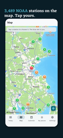
It carries NOAA's harmonic constants for 3,489 stations, so the tide is calculated right there, with no signal, on the boat or out on the flats, for any date you ask for.
FREE, FOREVER
· 3,489 NOAA tide stations: every U.S. coast and territory, plus 238 abroad
· The curve and the highs and lows for today and tomorrow. Drag it to read the water at any hour
· Find your station by GPS, or search a beach, a town or a ZIP code
· Times in the station's own time zone, with daylight saving handled
· Sun, moon and today's solunar times
· National Weather Service alerts and today's rip current risk from the NWS surf forecast
· A heads-up on the Today screen when a high tide in the next 7 days could reach NOAA's flood line
· The next tide on your Apple Watch face, and a Control Center button that shows it
· Find any station from Spotlight or ask Siri for it
· Feet or metres, 12 or 24 hour, English and Spanish, dark mode
No ads, on the free side either.
TIDEBOOK PRO, ONE PAYMENT
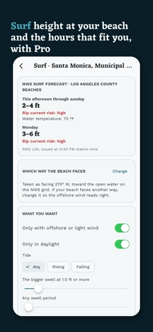
· Surf view: the NWS wave height at the beach, both swells with direction and period, offshore or onshore wind for your beach, and the hours that fit what you want
· Flood watch: the high tides of the year that reach the flood line, NOAA's odds for each day, and an alert at the line that keeps working even without Pro
· Tide finder: set a mark, daylight only and the days of the week, and get every date in the coming months. On devices with Apple Intelligence you can just type it, like "minus tides on weekends"
· When can I go: set your own limits for current, wind and tide and see the hours that meet all of them
· The whole week ahead and any month of any year
· Tide alerts, negative tides included, for clamming
· Live sensor level against the table at 238 stations, so you see what the weather is doing to the water
· Wind, waves and water temperature now, and the NWS forecast for the next 3 days
· Tidal currents on the same chart at 2,785 NOAA current stations, worked out on the phone
· The month as a PDF or CSV, or into your calendar
· Apple Watch with your favorite stations, Lock Screen widget and a countdown to the next tide
Pro works with Family Sharing. You can try all of it free for 7 days first: nothing is charged, nothing renews, and on day 8 it locks again until you buy it.
WHERE THE NUMBERS COME FROM
Every number says which NOAA station it comes from and how far it is. For subordinate stations you also see the reference station and the offsets. The engine is checked against the highs and lows NOAA publishes, station by station.
Tide and current data from NOAA CO-OPS and forecasts from the National Weather Service, public domain. Tidebook is not affiliated with NOAA or the NWS. The tide table does not include wind, pressure or river flow, which move the real water. Tidebook is a planning tool and does not replace a nautical chart.