

TopoWalk is made and published by Zsolt Bencze. AppBrain is an independent app data site and isn't affiliated with Zsolt Bencze. The app name, icon, screenshots and description belong to Zsolt Bencze and are shown as published on the App Store.
AppBrain's verdict
- Last updated
- April 18, 2026
Rankings
App Store top chartsApp Store Rankings for TopoWalk
Competitors
Similar apps and more from Zsolt BenczeAlternatives to TopoWalk


More from Zsolt Bencze


Releases
Updates seen on the App Store- Version
- 1.1
- Launched
- April 2026
No changelog data
User feedback
Ratings and reviews on the App StoreComments on TopoWalk for iOS
We don't have enough comments to show example comments. Please check back later.
Technology
Found in the app by AppBrain- Price
- Free
- App size
- 2.42 MB
- Content rating
- Everyone
Technologies used by TopoWalk
About the app and developer
About TopoWalk
TopoWalk is a navigation app developed by Zsolt Bencze.
User Ratings
The app has no ratings yet.
App Information
TopoWalk is freely available from the App Store. The app size is 2.42 MB. The latest version available is 1.1. The last update was on April 18, 2026.
Technical Requirements
The app has a content rating of Everyone. The app has been available on the App Store since April 2026.
Developer information for Zsolt Bencze
Address:
Store listing
By Zsolt Bencze, from the App Store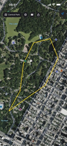


Description by Zsolt Bencze Written by the developer, not by AppBrain. Click to read.
WALK ANY BOUNDARY
Load land parcels, property boundaries, or hiking trails from GPX, KML, DXF, and Shapefile formats. TopoWalk shows each waypoint on a satellite map with a yellow boundary line connecting them.
GPS GUIDANCE
Real-time distance to the next waypoint, off-trail warnings, and an audio chime when you arrive within 1 meter of each point. Never miss a boundary corner again.
CONVERT BETWEEN FORMATS
TopoWalk is the only app that converts between all major surveying and trail file formats. Import a KML cadastral map from a surveyor, convert it to GPX for your hiking app, export as DXF for AutoCAD, or save as Shapefile for GIS software. One tap to convert — no desktop software needed.
Supported conversions:
• GPX ↔ KML ↔ DXF ↔ Shapefile (SHP)
• Import from email, Files app, or any cloud storage
• Export and share in any format
TRACK YOUR PROGRESS
See how many waypoints you've visited, total distance walked, land area and perimeter calculations — all updating live as you walk.
44 WORLD LANDMARKS INCLUDED
Explore boundaries of famous landmarks: Buckingham Palace, Taj Mahal, Vatican City, Stonehenge, Machu Picchu, Forbidden City, and many more — all with real satellite-accurate boundaries from OpenStreetMap.
FREE FEATURES
• GPX file support
• GPS-guided walking with audio alerts
• Progress tracking and distance display
• 44 bundled world landmark trails
TOPOWALK PRO (one-time purchase)
• KML, DXF, and Shapefile import & export
• Convert between all formats (GPX, KML, DXF, SHP)
• Area and perimeter calculations
• Share trails with others