

UK Waterways Map
UK Waterways Map is made and published by Jack Finnis. AppBrain is an independent app data site and isn't affiliated with Jack Finnis. The app name, icon, screenshots and description belong to Jack Finnis and are shown as published on the App Store.
AppBrain's verdict
- Last updated
- October 21, 2025
Rankings
App Store top chartsApp Store Rankings for UK Waterways Map
Competitors
Similar apps and more from Jack FinnisAlternatives to UK Waterways Map


More from Jack Finnis


Releases
Updates seen on the App Store- Version
- 2.2
- Launched
- November 2024
No changelog data
User feedback
Ratings and reviews on the App StoreComments on UK Waterways Map for iOS
We don't have enough comments to show example comments. Please check back later.
Technology
Found in the app by AppBrain- Price
- Free
- App size
- 4.46 MB
- Content rating
- Everyone
Technologies used by UK Waterways Map
About the app and developer
About UK Waterways Map
UK Waterways Map is a navigation app developed by Jack Finnis.
What is the rating of UK Waterways Map?
UK Waterways Map has no ratings yet.
Is UK Waterways Map free?
UK Waterways Map is free. The app size is 4.46 MB. The latest version available is 2.2. The last update was on October 21, 2025.
What are the requirements for UK Waterways Map?
The app has a content rating of Everyone. The app has been available on the App Store since November 2024.
Developer information for Jack Finnis
Address:
Store listing
By Jack Finnis, from the App Store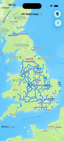


Description by Jack Finnis Written by the developer, not by AppBrain. Click to read.
KEY FEATURES
Detailed maps of over 500 UK waterways
Navigate all major canal systems, rivers, and navigations in England, Wales and Scotland.
Annotate the map with the location of locks, weirs, access points and other features.
Your map annotations are automatically saved and synced across all your devices.
Measure the distance between any two points along a waterway.
Get turn-by-turn directions using Apple Maps.
PERFECT FOR
BOATERS - Plan narrowboat holidays with precise canal routes and distance measurements.
PADDLERS - Kayakers, canoeists, and paddleboarders can find and log access points, locks and weirs.
ANGLERS - Find and log the best fishing spots.
WALKERS & CYCLISTS - Follow towpaths with accurate distance measurements.
SWIMMERS - Discover swimming spots and access points.
ANYONE who wants to discover the hidden beauty of Britain's canal and river network.