

Wegwiesel is made and published by Thomas Peterson. AppBrain is an independent app data site and isn't affiliated with Thomas Peterson. The app name, icon, screenshots and description belong to Thomas Peterson and are shown as published on the App Store.
AppBrain's verdict
- Last updated
- June 27, 2026
Rankings
App Store top chartsApp Store Rankings for Wegwiesel
Competitors
Similar apps and more from Thomas PetersonAlternatives to Wegwiesel


Releases
Updates seen on the App Store- Version
- 2.4.6
- Launched
- April 2026
No changelog data
User feedback
Ratings and reviews on the App StoreComments on Wegwiesel for iOS
We don't have enough comments to show example comments. Please check back later.
Technology
Found in the app by AppBrain- Price
- Free
- App size
- 26.1 MB
- Content rating
- Everyone
Technologies used by Wegwiesel
About the app and developer
About Wegwiesel
Wegwiesel is a navigation app developed by Thomas Peterson.
What is the rating of Wegwiesel?
Wegwiesel has no ratings yet.
Is Wegwiesel free?
Wegwiesel is free. The app size is 26.10 MB. The latest version available is 2.4.6. The last update was on June 27, 2026.
What are the requirements for Wegwiesel?
The app has a content rating of Everyone. The app has been available on the App Store since April 2026.
Developer information for Thomas Peterson
Address:
Frequently asked questions about Wegwiesel
Is Wegwiesel free?
Yes. Wegwiesel is free on the App Store.
Is Wegwiesel still available?
Yes. Wegwiesel is on the App Store, and the last update we saw was on June 27, 2026.
How large is Wegwiesel?
Wegwiesel is 26.10 MB.
Is Wegwiesel suitable for children?
App Store rates the content of Wegwiesel as suitable for everyone.
Who made Wegwiesel?
Wegwiesel was developed by Thomas Peterson. It is listed in the navigation category on the App Store.
What are the best alternatives to Wegwiesel?
People looking at Wegwiesel also look at these navigation apps: PedalPilot, Radtouren Nördl. Harzvorland, Maerker Brandenburg, Rundtour Braunschweiger Land, eFuelsNow.
Store listing
By Thomas Peterson, from the App Store



Description by Thomas Peterson Written by the developer, not by AppBrain. Click to read.
• Running, car (130 km/h), car with trailer (80 km/h)
OFFLINE-FIRST
• Map tiles are cached automatically — anything you've looked at is available offline
• Offline maps menu to pre-download viewports (zoom 8–15)
• Real offline router with a pure-Dart A* core and trekking profile, clean fallback to BRouter
• Saved routes work fully without a network
LIVE NAVIGATION
• Phone turn-by-turn with spoken voice (German + English)
• Map heading-up or north-up, ETA shown as clock time
• Automatic re-routing when you drift more than 50 m off course
• Apple Watch companion: next turn, distance and remaining time on the watch face — phone stays in the pocket
RECORD YOUR RIDE
• GPS tracking with live stats (distance, speed, ascent, calories)
• Pause/resume, GPX export when done
• Crash-safe — every 10 points are flushed to disk
• Share your live position: 12-hour link, no account
HIKING & BIKEPACKING
• Prominent hiking difficulty preset, prefer-waymarked-trails toggle
• Stage planner with sunrise/sunset, weather forecast and automatic overnight suggestions
• Pause recommendations: one picnic spot or shelter every 1.5 h of walking
• Bikepacking mode with camping, water, shelters and train stations in the POI search
DISCOVER ROUTES
• Public route library: publish your tours with one tap
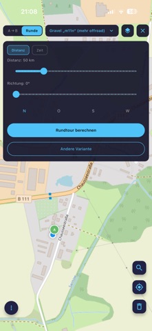
• Filter by distance, proximity and search term
• Heatmap overlay shows where the community rides
SURFACE & MAP
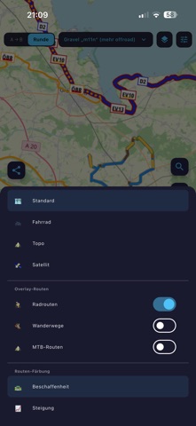
• Route colored by surface type (asphalt, paving, gravel, unpaved, offroad)
• Elevation profile with hover sync, 6 color modes
• Hillshading overlay for terrain context
• Sights along the way with Wikipedia thumbnails
EXPORT & DEVICES
• GPX export for any bike computer
• Push routes via Bluetooth straight to the Garmin Edge (custom Connect IQ app)
• Hand off to the Wahoo Companion app (Bolt/Roam/Ace)
• Import tour URLs (e.g. Komoot tour links)
FOR ATHLETES
• FTP test segment finder: matching climb or flat segments in a radius, scored by test type (20-min, 8-min, Ramp, Sweet Spot)
WHAT WEGWIESEL DOESN'T DO
• No tracking cookies, no ads, no user profiles
• No subscription, no in-app purchases
• No forced cloud sync
Wegwiesel is a free project by a cyclist for everyone who heads outdoors. Feedback welcome.
Based on BRouter and OpenStreetMap.