

Wildfire Tracker & Alert Map
Wildfire Tracker & Alert Map is made and published by Brite Technologies. AppBrain is an independent app data site and isn't affiliated with Brite Technologies. The app name, icon, screenshots and description belong to Brite Technologies and are shown as published on the App Store.
AppBrain's verdict
- Last updated
- August 10, 2026
- Size
- 7.77 MB
User feedback
Ratings and reviews on the App StoreComments on Wildfire Tracker & Alert Map for iOS
We don't have enough comments to show example comments. Please check back later.
Store listing
By Brite Technologies, from the App Store


Description by Brite Technologies Written by the developer, not by AppBrain. Click to read.
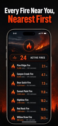
Wildfire Tracker shows the fires burning around you, how far away each one is, how big it has grown and how much of it is contained. No account, no ads, no sign-up wall between you and the map.
KEY FEATURES:
• Active fires near you — pulled from the same interagency incident feed the fire services and the news use, with each fire's name, size, containment and cause.
• Distance that means something — see how far the nearest active fire is burning, and whether you are downwind of it. Wind direction is the question people actually ask, and almost nothing else answers it.
• Smoke and air quality — US AQI and PM2.5 for your location, hour by hour, with plain guidance at every band. Smoke reaches far more people than flame ever does.
• Fire weather outlook — humidity, wind and gusts drive fire behaviour. See when conditions turn critical over the next days, not just what is burning today.
• Alerts you can trust — set a radius from your location or any place you save, and get notified when an active fire is reported inside it. Contained fires and prescribed burns are labelled, not alarmed about.
• Wildfire safety, explained — leave early, what belongs in a go-bag, why embers rather than flames burn most houses, and what a Red Flag Warning actually means.
WHO IS IT FOR:
People who live where fire season is a fact of life, anyone downwind of the smoke, homeowners in the wildland-urban interface, ranchers and smallholders, parents watching the air, and anyone who has evacuated and still needs to watch the house they left.
HOW IT WORKS:
Saved places let you watch home, the ranch or a relative's address even when you are somewhere else. Fire data comes from the US interagency reporting system, with NASA's global wildfire feed outside the United States. Weather, smoke and air quality come from Open-Meteo, and official Red Flag Warnings come from the National Weather Service.
Wildfire Tracker is for personal safety awareness and never replaces an official evacuation order. Fire reporting lags reality, small fires can go unreported for hours, and conditions change faster than any feed. If an agency tells you to leave, leave.
Support: hello@britetodo.com
Terms of Use (EULA): https://www.apple.com/legal/internet-services/itunes/dev/stdeula/
Privacy Policy: https://britetodo.com/legal/PrivacyPolicyBrite.pdf
Safety and technology
Found in the app by AppBrain- Price
- Free
- App size
- 7.77 MB
- Content rating
- Everyone
Technologies used by Wildfire Tracker & Alert Map
Releases
Updates seen on the App Store- Version
- 1.0.1
- Launched
- August 2026
No changelog data
Alternatives
Similar apps and more from Brite TechnologiesMore from Brite Technologies



Rankings
App Store top chartsApp Store Rankings for Wildfire Tracker & Alert Map
About the app and developer
About Wildfire Tracker & Alert Map
Wildfire Tracker & Alert Map is a weather app developed by Brite Technologies.
What is the rating of Wildfire Tracker & Alert Map?
Wildfire Tracker & Alert Map has no ratings yet.
Is Wildfire Tracker & Alert Map free?
Wildfire Tracker & Alert Map is free. The app size is 7.77 MB. The latest version available is 1.0.1. The last update was on August 10, 2026.
What are the requirements for Wildfire Tracker & Alert Map?
The app has a content rating of Everyone. The app has been available on the App Store since August 2026.
Developer information for Brite Technologies
Address: