WildMap is the dedicated hunting map for Australian hunters. See which land you can legally access, what species you're permitted to take, and exactly where you are.
IMPORTANT - WildMap IS NOT A GOVERNMENT APP
WildMap is an independent app by Northset Advisory Pty Ltd (ABN 40 386 582 970). We're not part of any government, not endorsed by one, and we don't run government services. Every source of data in the app, government and non-government, is listed at the bottom of this page. Always check tenure and hunting rules with the relevant authority before you hunt.
KEY FEATURES
- Cadastral land tenure - colour coded boundaries across VIC, NSW, TAS and QLD, with owner and tenure type lookup in Victoria
- Victoria GMA zones - hunting area overlays with species tables (sambar, hog deer, fallow deer, duck, pest species)
- NSW State Forests - R-Licence forests with booking categories, species, seasons, bag limits and DPIRD booking links
- Tasmania - Game Reserve boundaries with seasons, bag limits and permitted methods, plus tenure overlays
- New Zealand - public conservation land and DOC hunting blocks
- Fire history, fire incidents, road closures, Victorian waterways, tracks and trails, Victorian Alpine huts, plus camping grounds, fuel and general stores Australia wide
- Thermal Flow (Premium) - thermals across the terrain, hour by hour
- Scent Cone - project your scent downwind from any point
- Line of Sight - see what's visible from a glassing spot
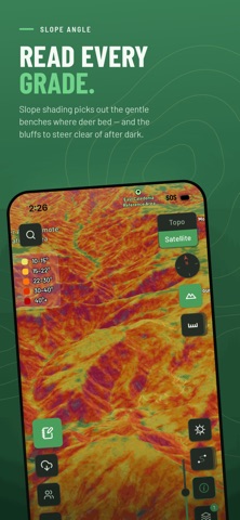
- Terrain - 3D view, contours, slope angle, aspect and elevation bands
- Plan a route, navigate it and retrace your steps
- Offline maps - download your area before you go
- GPS tracking, waypoints, a harvest log and field notes with photos
- Weather forecast, wind compass and pressure trend
- Sign in to sync across your iPhone and iPad
OFFICIAL SOURCES FOR GOVERNMENT INFORMATION
Each map layer also links to its source in the app.
Victoria
- Vicmap Property (tenure, cadastre), Vicmap Hydro (waterways), Vicmap Elevation (terrain), State of Victoria: https://www.data.vic.gov.au
- Game Management Authority (hunting zones, seasons): https://www.gma.vic.gov.au/hunting
- MapShareVic (hunting areas, road closures): https://mapshare.vic.gov.au
- Dept of Energy, Environment and Climate Action (fire history): https://discover.data.vic.gov.au
- Parks Victoria (closures): https://www.parks.vic.gov.au
- Emergency Management Victoria (fire incidents): https://www.emergency.vic.gov.au
New South Wales
- Spatial Services (tenure): https://data.nsw.gov.au
- Primary Industries and Regional Development (hunting, R-Licence): https://www.dpird.nsw.gov.au/hunting
- Forestry Corporation of NSW (state forests, exclusions): https://www.forestrycorporation.com.au
- National Parks and Wildlife Service (fire history): https://datasets.seed.nsw.gov.au
Tasmania
- the LIST (tenure, cadastre, Game Reserves, fire history, elevation): https://www.thelist.tas.gov.au
- Natural Resources and Environment Tasmania (game management): https://nre.tas.gov.au/wildlife-management/management-of-wildlife/
Queensland
- State of Queensland (cadastre, QPWS fire history, fire scar mapping): https://www.data.qld.gov.au
New Zealand
- Department of Conservation (conservation land, hunting blocks): https://www.doc.govt.nz/parks-and-recreation/things-to-do/hunting/
OTHER SOURCES (NOT GOVERNMENT)
- OpenStreetMap contributors (tracks and trails, Alpine huts, camping grounds, petrol stations and stores): https://www.openstreetmap.org/copyright
- Copernicus DEM, ESA (terrain outside VIC and TAS): https://dataspace.copernicus.eu
- Open-Meteo (weather forecast): https://open-meteo.com
- Mapbox (base map and satellite imagery): https://www.mapbox.com
WildMap is a mapping and planning tool. Hunters are solely responsible for verifying land tenure and compliance with State hunting laws before entering any property.
Privacy: https://wildmap.com.au/privacy
Terms: https://wildmap.com.au/terms
Support: https://wildmap.com.au/support
Show more
Show less