

Yoshi's GPS Tracker
Yoshi's GPS Tracker is made and published by Yoshiaki Uno. AppBrain is an independent app data site and isn't affiliated with Yoshiaki Uno. The app name, icon, screenshots and description belong to Yoshiaki Uno and are shown as published on the App Store.
AppBrain's verdict
- Last updated
- October 15, 2026
- Size
- 6.41 MB
User feedback
Ratings and reviews on the App StoreComments on Yoshi's GPS Tracker for iOS
We don't have enough comments to show example comments. Please check back later.
Store listing
By Yoshiaki Uno, from the App Store



Description by Yoshiaki Uno Written by the developer, not by AppBrain. Click to read.
It makes it easy to capture GPX data for adding location information later to photos taken with cameras that do not have built-in GPS. It is also great for travel photography and everyday walks.
■ Recommended for
- People who want to add location data later to photos taken with digital or film cameras
- People who want to record their routes and review them on a map afterward
- People who want to use GPX data in photo editing software
■ GPX Recording
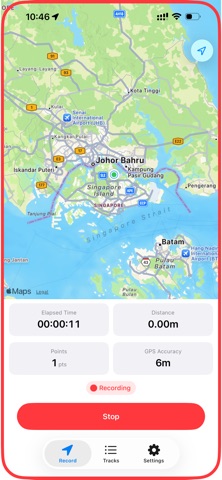
Accurately records your route in GPX 1.1 format. While recording, the route is drawn in real time as a red line on the map, and you can check elapsed time, distance, recorded points, and GPS accuracy. Data is written in a streaming format, so even if the app unexpectedly closes, what has already been recorded is preserved.
■ Background Recording
Recording continues in the background even when the screen is locked or other apps are in use. You can keep capturing GPS logs without interruption while taking photos with your camera. A red frame on the screen shows at a glance that recording is active.
■ Geofence-Based Auto Recording
If you set a home position, recording starts automatically when you leave that area and stops when you return. This helps prevent missed recordings because you do not need to open the app manually. A hysteresis design also prevents repeated start and stop events near the boundary. Even when the app is not running, iOS geofencing can relaunch it and start recording automatically.
■ Auto Save and Export
After recording ends, GPX files can be copied automatically to a destination selected in the Files app, including iCloud Drive. This lets you use GPX data right away for photo editing on your computer. Manual export is also supported through AirDrop, email, and other share destinations.
■ Detailed Recording Settings
You can adjust the balance between recording precision and battery usage.
- Requested accuracy: Best / High / Around 10 m / Around 100 m
- Minimum distance interval: 1 m to 100 m (default: 10 m)
- Minimum time interval: 1 second to 120 seconds (default: 5 seconds)
- Accuracy filter: Automatically skips GPS points with low accuracy
- Forced recording interval: Records location at regular intervals even when there is no movement
■ Battery Management
Choose from three power modes: Power Saving, Balanced, and Performance. When the battery level falls below your configured threshold, the app shows a warning, and if it drops further, recording stops automatically and the data is saved. It also works with iOS Low Power Mode.
■ Manage Recorded Data
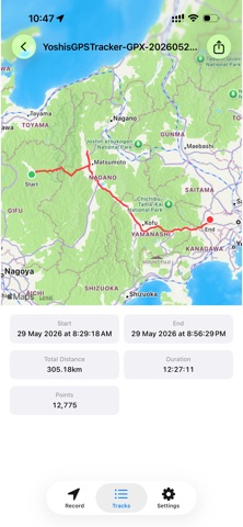
Recorded data can be viewed in the list screen. Each entry shows the start and end time, travel distance, recording duration, and number of recorded points. Tap an entry to view the full route on the map. You can rename entries, delete unnecessary data, and export GPX files. Sorting by date, distance, or duration is also supported.
■ Privacy First
All data is stored on your iPhone, and nothing is sent to external servers. The app includes no ads, analytics, or tracking SDKs. The auto-save feature only copies files through the iOS file system to a destination selected by the user.
■ Other Features
- Storage space monitoring and automatic stop
- Debug log feature (Off / Standard / Verbose)
- Notifications for auto-record start and stop
- Crash recovery for incomplete recording files
■ Requirements
- iOS 17 or later
- iPhone only
- Signing in to iCloud is required if you want to use iCloud Drive as an auto-save destination
■ Example Use of GPX Files
Recorded GPX files can be used in photo editing software that supports GPX import. By matching photo capture time with GPS log timestamps, location information can be added automatically.
■ Coming Soon
A Mac app for adding location information to photos using GPX data is planned. Together with this app, it will make the workflow from GPS logging to photo geotagging even smoother.
Safety and technology
Found in the app by AppBrain- Price
- Free
- App size
- 6.41 MB
- Content rating
- Everyone
Technologies used by Yoshi's GPS Tracker
Releases
Updates seen on the App Store- Version
- 1.5.0
- Launched
- June 2026
No changelog data
Alternatives
Similar apps and more from Yoshiaki UnoAlternatives to Yoshi's GPS Tracker


Rankings
App Store top chartsApp Store Rankings for Yoshi's GPS Tracker
About the app and developer
About Yoshi's GPS Tracker
Yoshi's GPS Tracker is a navigation app developed by Yoshiaki Uno.
What is the rating of Yoshi's GPS Tracker?
Yoshi's GPS Tracker has no ratings yet.
Is Yoshi's GPS Tracker free?
Yoshi's GPS Tracker is free. The app size is 6.41 MB. The latest version available is 1.5.0. The last update was on October 15, 2026.
What are the requirements for Yoshi's GPS Tracker?
The app has a content rating of Everyone. The app has been available on the App Store since June 2026.
Developer information for Yoshiaki Uno
Address: