AppBrain
|
Apps
Apps
Apps being viewed right now
Trending apps today
Most popular apps
All-time most downloaded apps
Top rated apps
Statistics
Docs
Developers
Sign up
Log in
Android Apps
>
Maps & Navigation
>
Paid
Category
Maps & Navigation
Sort by
Trending
Recent downloads
All-time downloads
Top rated
Popular in
Filter by
Off
Free
Paid
New
Updated
Price Reduced
No ads
Page 5 of the
best Paid Maps & Navigation Apps for Android
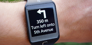
Gear 2 Navigation
SmartWatch Studios
This app displays Google Navigation instructions on your Samsung Gear 2 smartwatch. It needs the free companion app "Gear 2 Navigation" from Samsung Galaxy Apps to work. How to use: - Inst…
$2.99
3.0
1,000+ downloads
|
Maps & Navigation
3.0
$2.99
SmartWatch Studios
1,000+ downloads
TRANSPORTATION
Gear 2 Navigation
This app displays Google Navigation instructions on your Samsung Gear 2 smartwatch. It needs the free companion app &qu…
Headunit Reloaded Emulator HUR
AAWireless
Headunit Receiver emulator for Android Auto. How to use the app? USB Mode Plug in the USB to your device (in case of tablet use an OTG cable), when prompted make sure you allow HUR to be the defau…
$4.99
2.7
100,000+ downloads
|
Maps & Navigation
2.7
$4.99
AAWireless
100,000+ downloads
TRANSPORTATION
Headunit Reloaded Emulator HUR
Headunit Receiver emulator for Android Auto. How to use the app? USB Mode Plug in the USB to your device (in case of…
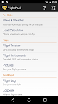
Ultramagic Balloon FlightPack
Ultramagic Balloons
FlightPack is an app for tablets and phones that gives Hot Air Balloon pilots all the information and tools required for flight in one place! It includes weather, flight tracker, balloon loading info…
$10.99
2.6
1,000+ downloads
|
Maps & Navigation
2.6
$10.99
Ultramagic Balloons
1,000+ downloads
TRANSPORTATION
Ultramagic Balloon FlightPack
FlightPack is an app for tablets and phones that gives Hot Air Balloon pilots all the information and tools required fo…
National Forests Map Guide USA – Click to show
National Forests Map Guide USA
GeoPOI LLC
The United States of America is a vast land full of lush forests, indescribable landscapes, and fascinating history. You may already know some of the iconic landmarks and wildernesses that the US has…
$1.49
3.2
500+ downloads
|
Maps & Navigation
3.2
$1.49
GeoPOI LLC
500+ downloads
TRANSPORTATION
National Forests Map Guide USA
The United States of America is a vast land full of lush forests, indescribable landscapes, and fascinating history. Yo…
TwoNav Premium: Maps & Routes
TwoNav
TURN YOUR SMARTPHONE INTO A POWERFUL NAVIGATION SYSTEM Explore your environment with the best maps, travel the most spectacular routes, improve your performance and, above all, practice your outdoor …
$8.99
2.0
10,000+ downloads
|
Maps & Navigation
2.0
$8.99
TwoNav
10,000+ downloads
TRANSPORTATION
TwoNav Premium: Maps & Routes
TURN YOUR SMARTPHONE INTO A POWERFUL NAVIGATION SYSTEM Explore your environment with the best maps, travel the most spe…
Wisconsin Lakes GPS Charts – Click to show
Wisconsin Lakes GPS Charts
FLYTOMAP INC
Flytomap is a valid and interesting alternative, Worldwide Marine and Outdoor Maps available when connected, thanks to viewer.flytomap.com Worldwide Satellite images overlay on charts Worldwide Terr…
$3.99
1.6
100+ downloads
|
Maps & Navigation
1.6
$3.99
FLYTOMAP INC
100+ downloads
TRANSPORTATION
Wisconsin Lakes GPS Charts
Flytomap is a valid and interesting alternative, Worldwide Marine and Outdoor Maps available when connected, thanks to …
Find My Device(Imei Tracker)
CodeEr
Find My Device (Imei Tracker) is the essential tracking tool for anyone who has experienced the stress, worry, and inconvenience associated with a lost or stolen device. What’s more, it’s…
$23.99
1.0
1,000+ downloads
|
Maps & Navigation
1.0
$23.99
CodeEr
1,000+ downloads
TRANSPORTATION
Find My Device(Imei Tracker)
Find My Device (Imei Tracker) is the essential tracking tool for anyone who has experienced the stress, worry, and inco…
Jeep Inclinometer Pro – Click to show
Jeep Inclinometer Pro
Fabio Paracchini
Jeep Inclinometer is an offroad inclinometer designed by Jeep enthusiasts for Jeep enthusiasts to measure your Jeep's angle of pitch and roll while venturing offroad. Simply calibrate the App while i…
$1.80
1.0
500+ downloads
|
Maps & Navigation
1.0
$1.80
Fabio Paracchini
500+ downloads
TRANSPORTATION
Jeep Inclinometer Pro
Jeep Inclinometer is an offroad inclinometer designed by Jeep enthusiasts for Jeep enthusiasts to measure your Jeep's a…
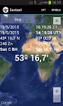
Sextant – This app may contain mature content
Sextant
Navigational Algorithms
Celestial navigation - Astronavigation For training or improving your skills with a marine sextant, an aircraft octant (bubble), an artificial horizon, or a theodolite. - Real time calculation of t…
$1.99
0.0
100+ downloads
|
Maps & Navigation
0.0
$1.99
Navigational Algorithms
100+ downloads
TRANSPORTATION
Sextant
Celestial navigation - Astronavigation For training or improving your skills with a marine sextant, an aircraft octant…
Places for campers – Click to show
Places for campers
VanLife
Application for camper users and others. While driving, it application notifies You about approaching a camper sites. Maybe it's worth staying at a local small campsite rather than squeezing in la…
$0.63
0.0
10+ downloads
|
Maps & Navigation
0.0
$0.63
VanLife
10+ downloads
TRANSPORTATION
Places for campers
Application for camper users and others. While driving, it application notifies You about approaching a camper sites.…
Compass Eye Bearing Compass
Electric Pocket
A Professional Bearing Compass with Augmented Reality and upto 8x zoom designed to help navigate on land, sea and air and used much like a pair of Compass Binoculars. When held vertically it shows th…
$6.49
0.0
100+ downloads
|
Maps & Navigation
0.0
$6.49
Electric Pocket
100+ downloads
TRANSPORTATION
Compass Eye Bearing Compass
A Professional Bearing Compass with Augmented Reality and upto 8x zoom designed to help navigate on land, sea and air a…
Lake Como GPS Map Navigator – Click to show
Lake Como GPS Map Navigator
FLYTOMAP INC
Flytomap is a valid and interesting alternative, Featured on the Deck Featured on Geomedia Worldwide Marine and Outdoor Maps available when connected, thanks to viewer.flytomap.com Worldwide Satelli…
$3.99
0.0
10+ downloads
|
Maps & Navigation
0.0
$3.99
FLYTOMAP INC
10+ downloads
TRANSPORTATION
Lake Como GPS Map Navigator
Flytomap is a valid and interesting alternative, Featured on the Deck Featured on Geomedia Worldwide Marine and Outdoo…
Toledo Bend RSVR Offline Chart – Click to show
Toledo Bend RSVR Offline Chart
FLYTOMAP INC
Flytomap is a valid and interesting alternative, Featured on the Deck Featured on Geomedia Worldwide Marine and Outdoor Maps available when connected, thanks to viewer.flytomap.com Worldwide Satellit…
$3.99
0.0
100+ downloads
|
Maps & Navigation
0.0
$3.99
FLYTOMAP INC
100+ downloads
TRANSPORTATION
Toledo Bend RSVR Offline Chart
Flytomap is a valid and interesting alternative, Featured on the Deck Featured on Geomedia Worldwide Marine and Outdoor…
Lake Itasca Gps Map Navigator – Click to show
Lake Itasca Gps Map Navigator
FLYTOMAP INC
Flytomap is a valid and interesting alternative, Benetti Yachts Featured on the Deck Featured on Geomedia Worldwide Marine and Outdoor Maps available when connected, thanks to viewer.flytomap.com Wor…
$3.99
0.0
1+ downloads
|
Maps & Navigation
0.0
$3.99
FLYTOMAP INC
1+ downloads
TRANSPORTATION
Lake Itasca Gps Map Navigator
Flytomap is a valid and interesting alternative, Benetti Yachts Featured on the Deck Featured on Geomedia Worldwide Mar…
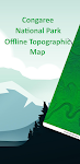
Congaree Offline Topo Map – Click to show
Congaree Offline Topo Map
XDivide Geospatial
Designed with simplicity in mind, this app offers an intuitive user interface that enables you to quickly and easily find information about surroundings, without any prior technical knowledge or expe…
$0.99
0.0
0+ downloads
|
Maps & Navigation
0.0
$0.99
XDivide Geospatial
0+ downloads
TRANSPORTATION
Congaree Offline Topo Map
Designed with simplicity in mind, this app offers an intuitive user interface that enables you to quickly and easily fi…
Badger Lake - IOWA GPS Map – Click to show
Badger Lake - IOWA GPS Map
FLYTOMAP
Flytomap is a valid and interesting alternative, Benetti Yachts Featured on the Deck Featured on Geomedia Worldwide Marine and Outdoor Maps available when connected, thanks to viewer.flytomap.com Wor…
$2.99
0.0
1+ downloads
|
Maps & Navigation
0.0
$2.99
FLYTOMAP
1+ downloads
TRANSPORTATION
Badger Lake - IOWA GPS Map
Flytomap is a valid and interesting alternative, Benetti Yachts Featured on the Deck Featured on Geomedia Worldwide Mar…
نافيتيل عربي - خرائط الصحراء
نافتيل عربي
تطبيق خرائط البر يوفر لك احدث وافضل الخرائط البرية لجميع الدول العربية تعمل على تطبيق نافتيل نوفره لك باللغة العربية وتعمل على الاقمار الصناعية بدون انترنت وبدون ابراج الجوال وفي وضع الطيران عن طريق…
$10.99
0.0
100+ downloads
|
Maps & Navigation
0.0
$10.99
نافتيل عربي
100+ downloads
TRANSPORTATION
نافيتيل عربي - خرائط الصحراء
تطبيق خرائط البر يوفر لك احدث وافضل الخرائط البرية لجميع الدول العربية تعمل على تطبيق نافتيل نوفره لك باللغة العربية و…
The Blue Hills Reservation Map – Click to show
The Blue Hills Reservation Map
FLYTOMAP INC
Flytomap is a valid and interesting alternative, Featured on the Deck Featured on Geomedia Try now the new FlyToMap web viewer to see all available maps worldwide !!! Visit viewer.flytomap.com &ldqu…
$3.99
0.0
10+ downloads
|
Maps & Navigation
0.0
$3.99
FLYTOMAP INC
10+ downloads
TRANSPORTATION
The Blue Hills Reservation Map
Flytomap is a valid and interesting alternative, Featured on the Deck Featured on Geomedia Try now the new FlyToMap web…
Thorsborne Trail
Jonathan Ide
This is the only app for hikers either walking or thinking of walking the iconic Thorsborne Trail on World Heritage listed Hinchinbrook Island in Far North Queensland, Australia. It is the perfect el…
$4.49
0.0
1,000+ downloads
|
Maps & Navigation
0.0
$4.49
Jonathan Ide
1,000+ downloads
TRANSPORTATION
Thorsborne Trail
This is the only app for hikers either walking or thinking of walking the iconic Thorsborne Trail on World Heritage lis…
Huron Erie Ontario Lakes Chart – Click to show
Huron Erie Ontario Lakes Chart
FLYTOMAP INC
Flytomap is a valid and interesting alternative, Featured on the Deck Featured on Geomedia Worldwide Marine and Outdoor Maps available when connected, thanks to viewer.flytomap.com Worldwide Satelli…
$3.99
0.0
10+ downloads
|
Maps & Navigation
0.0
$3.99
FLYTOMAP INC
10+ downloads
TRANSPORTATION
Huron Erie Ontario Lakes Chart
Flytomap is a valid and interesting alternative, Featured on the Deck Featured on Geomedia Worldwide Marine and Outdoo…
United States
United Kingdom
Germany
Norway
Sweden
Australia
Netherlands
Italy
Denmark
Hong Kong
Brazil
France
Canada
Spain
Portugal
South Korea
Japan
Poland
Hungary
India
Finland
Thailand
Russia
General
Overall
Applications
Games
Join AppBrain
Join AppBrain to get app recommendations
Apps
Art & Design
Auto & Vehicles
Beauty
Books & Reference
Business
Comics
Communication
Dating
Education
Entertainment
Events
Finance
Food & Drink
Health & Fitness
House & Home
Libraries & Demo
Lifestyle
Maps & Navigation
Medical
Music & Audio
News & Magazines
Parenting
Personalization
Photography
Productivity
Shopping
Social
Sports
Tools
Travel & Local
Video Players & Editors
Weather
Games
Action
Adventure
Arcade
Board
Card
Casino
Casual
Educational
Music
Puzzle
Racing
Role Playing
Simulation
Sports Games
Strategy
Trivia
Word